


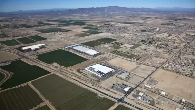
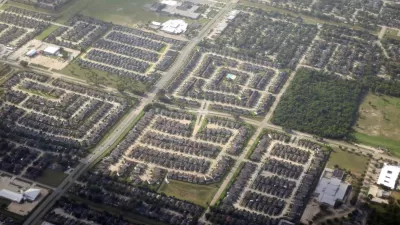
German photographer Christoph Gielen has trained his artistic eye on America's suburbs, capturing aerial images of sprawl "in all its geometric glory" in order to "startle the viewers," reports Ariel Schwartz.
When Gielen conceived of a project to produce photographs that would cause viewers to "reconsider how they live," he didn't want to capture just any old suburb from the air. Instead, he "researched foreclosure in different states and zoomed in on those with
the highest rates," explicitly connecting his images to the unsustainable phenomenon of "suburban hypergrowth and subsequent stagnancy."
"Using map data from the U.S. Geological Survey,
Gielen was able to zoom in on suburban sprawl in individual counties," notes Schwartz. "He
visited a number of developments, trying to understand the makeup of
the communities and their selling points. In the end, he selected the
developments that he deemed most interesting for flyovers in a rented
helicopter. 'When you look at what regions had grown the fastest, which
ones were in decline, it was always Southwest Florida, the West Coast,'
says Gielen. 'Statistics is where I started.'"
"He ended with beautiful aerial photographs of sprawl in all its geometric glory," says Schwartz.
FULL STORY: The Hidden Beauty Of Suburban Sprawl


Capturing the Post-Pandemic City: The Power of 'Visual Prosecution'
Have you ever tried immersive photography to show how urban landscapes, with their ever-evolving stories, are changing post-pandemic? A three-time author of books about understanding the innate identities of urban places updates his perspective.
Arizona Tapping Groundwater to Fuel Suburban Growth
Critics say Arizona’s growth patterns are unsustainable and dangerous, given the depleted Colorado River and the state’s deepening reliance on groundwater.
How to Fix Racist Housing Policies: Sue the Suburbs
Strengthening U.S. Department of Housing and Urban Development's civil rights enforcement could send a powerful signal to communities resistant to changing discriminatory housing rules.

Planetizen Federal Action Tracker
A weekly monitor of how Trump’s orders and actions are impacting planners and planning in America.

Maui's Vacation Rental Debate Turns Ugly
Verbal attacks, misinformation campaigns and fistfights plague a high-stakes debate to convert thousands of vacation rentals into long-term housing.

San Francisco Suspends Traffic Calming Amidst Record Deaths
Citing “a challenging fiscal landscape,” the city will cease the program on the heels of 42 traffic deaths, including 24 pedestrians.

Amtrak Rolls Out New Orleans to Alabama “Mardi Gras” Train
The new service will operate morning and evening departures between Mobile and New Orleans.

The Subversive Car-Free Guide to Trump's Great American Road Trip
Car-free ways to access Chicagoland’s best tourist attractions.

San Antonio and Austin are Fusing Into one Massive Megaregion
The region spanning the two central Texas cities is growing fast, posing challenges for local infrastructure and water supplies.
Urban Design for Planners 1: Software Tools
This six-course series explores essential urban design concepts using open source software and equips planners with the tools they need to participate fully in the urban design process.
Planning for Universal Design
Learn the tools for implementing Universal Design in planning regulations.
Heyer Gruel & Associates PA
JM Goldson LLC
Custer County Colorado
City of Camden Redevelopment Agency
City of Astoria
Transportation Research & Education Center (TREC) at Portland State University
Jefferson Parish Government
Camden Redevelopment Agency
City of Claremont