


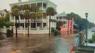
William Brangham takes a look at Norfolk, Virginia, where rising sea levels have made major floods increasingly commonplace – and increasingly burdensome for taxpayers.
Perched on the southern shore of Virginia and perforated by an extensive network of inlets, the City of Norfolk is at the forefront of the battle between coastal cities and a rising sea. Norfolk has always been vulnerable to occasional inundation, but in recent years, floods causing major property damage have become a nearly annual occurrence.
For Norfolk, the shift in sea level is compounded by geological factors that have caused the land to sink at roughly the same rate as the water rises. Thus, what happens in Norfolk may well be a sign of things to come for coastal towns throughout the country.
The city has consulted firms in the Netherlands, where settlements have held close to waterways for centuries, for insight on how to manage the dilemma in coming years. The solutions they proposed (by no means permanent) could cost upwards of $300 million. Mayor Paul Fraim argues that the Navy, which has a strong presence in Norfolk, has a shared responsibility for the protection of the area.
Brangham argues that public policy, such as subsidized flood insurance, has much to do with waterfront development patterns. By maintaining such policies, he writes, the government softens the risk of building in untenable areas, at the expense of taxpayers everywhere. "The private insurance industry got out of writing flood policies in risky areas many years ago, and now the federal government is currently the biggest backstop for losses in flood-prone areas."
In the face of unyielding tides, Fraim has proposed "retreat zones" that would designate areas unfit for future development. "I'm not sure the community is ready for that, but in the next twenty or thirty years, there will be places in the city that will just contain water all the time, and we need to be prepared for that inevitability."
FULL STORY: Rising tide: Norfolk, Va., struggles on the front lines of sea-level rise [VIDEO]

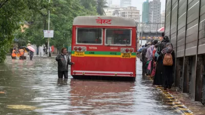
As Development in Flood-Prone Areas Continues, Cities Are Slow to Respond
Drawn by affordable property, low taxes, and job opportunities, high numbers of Americans continue to move to flood-prone areas even as the threat of catastrophic flooding grows.
Over 80 Million People Live in Flood Zones
New research shows a 24% increase in people living in flood-prone areas since 2000, prompting calls for increased adaptation measures.

Norfolk Plans for Resilience in the Face of Climate Change
The Ohio Creek Watershed Project aims to protect the city's coastline and prepare for future sea level rise.

Maui's Vacation Rental Debate Turns Ugly
Verbal attacks, misinformation campaigns and fistfights plague a high-stakes debate to convert thousands of vacation rentals into long-term housing.

Planetizen Federal Action Tracker
A weekly monitor of how Trump’s orders and actions are impacting planners and planning in America.

In Urban Planning, AI Prompting Could be the New Design Thinking
Creativity has long been key to great urban design. What if we see AI as our new creative partner?

King County Supportive Housing Program Offers Hope for Unhoused Residents
The county is taking a ‘Housing First’ approach that prioritizes getting people into housing, then offering wraparound supportive services.

Researchers Use AI to Get Clearer Picture of US Housing
Analysts are using artificial intelligence to supercharge their research by allowing them to comb through data faster. Though these AI tools can be error prone, they save time and housing researchers are optimistic about the future.

Making Shared Micromobility More Inclusive
Cities and shared mobility system operators can do more to include people with disabilities in planning and operations, per a new report.
Urban Design for Planners 1: Software Tools
This six-course series explores essential urban design concepts using open source software and equips planners with the tools they need to participate fully in the urban design process.
Planning for Universal Design
Learn the tools for implementing Universal Design in planning regulations.
planning NEXT
Appalachian Highlands Housing Partners
Mpact (founded as Rail~Volution)
City of Camden Redevelopment Agency
City of Astoria
City of Portland
City of Laramie