The true evolution of Ebenezer Howard's Garden City has yet to be realized, says Chris Abel, and today's digital design technology is poised to create a revolutionary vertical version.
This is an edited and updated version of an essay first published in the International Journal on Tall Buildings and Urban Habitat, 2010, Issue II.
"Understandably, architects have abandoned the flawed urban visions of the past century to focus on the new technologies of production and other more immediate issues. However, having now finally mastered the 'how' of production in the digital age, designers need to refocus on the 'what', and to re-imagine the shape of the modern city to meet the urgent challenges of this century."
Ebenezer Howard's Legacy
No other concept in architecture or urbanism evokes as powerful a response in the collective imagination as the Garden City. Surveying the great figures that have influenced the way we think about urban life and form since the 19th century, the eminent planner Peter Hall unequivocally nominates Ebenezer Howard as " the most important single character in this entire tale." However, as Hall explains, despite his fame – or maybe because of it - Howard's ideas have been widely misinterpreted. More than just a physical plan for decentralization, Howard's scheme for relocating industrial production in 'Satellite Towns' to be built on cheap farmland well beyond existing urban centres was also a radical blueprint for socio-economic reform, the keynote of which was local management and self-government. As well as owning shares in the land, the increasing value of which would flow back into the community, citizens would build their own homes with capital financed by co-operative societies, unions and similar self-governing bodies, in turn boosting the general economy. As Hall puts it, " forty years before John Maynard Keynes and Franklin Delano Roosevelt, Howard had arrived at the solution that society could spend its way out of a recession."
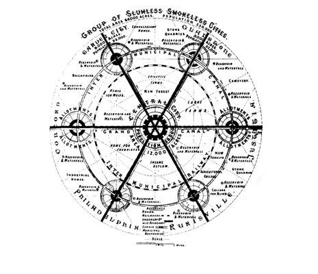
It was the famous diagrams of concentric new towns though, which stirred planners' and architects' imaginations, and even these, Hall argues, were mostly misunderstood. The full diagram of Howard's polycentric 'Social City' as originally published in the first edition of his work, Tomorrow: A Peaceful Path to Real Reform, shows six towns with a population of 32,000 each grouped in circular formation around a Central City of 58,000, all linked together by 'inter-municipal' canals, railways and roads across open countryside (Figure 1).
As Howard envisaged it, the whole arrangement of compact new towns and urban core was capable of housing a quarter of a million persons at medium densities. Conceived as a two-dimensional diagram and interpreted ever since by others in its more limited variations as 'dormitory' suburbs and semi-autonomous new towns, the concept of the Garden City was subsequently stripped of Howard's social agenda and developed exclusively as a physical plan. The networks of railways and canals which were such an important feature of Howard's strategy suffered the same fate, displaced by the automobile and Frank Lloyd Wright's own seductive vision of an ultra-low density city of single-family homes on one-acre plots, fueled in the post-war years by seemingly endless supplies of cheap land and gasoline. Rejecting low-density models and substituting the communal home for the individual house, Le Corbusier interpreted Howard's vision in his own way, creating a series of projects for a 'vertical garden city' comprised of tall buildings set in parkland. However, Le Corbusier's contrary interpretation failed to stem the general drift towards lower and lower urban densities. What now remains of Howard's legacy has devolved into countless automobile-dependent, repetitive garden suburbs around the world, the growth and maintenance of which are stretching the planet's natural resources to breaking point. Combining elements of both Howard's and Le Corbusier's visions together in a rare, infrastructure led urban strategy, only Singapore, with its 'constellation' of high-density new towns all linked together by a circular metro system ringing the port city, bears any resemblance to the polycentric city Howard planned.
Innovations in High-rise Architecture
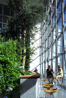
Figure 3, F+P.
For the most part, however, architecture and urban design around the world continues to evolve within a conventional and highly constrained urban framework shaped by commercial imperatives. While, following recent advances in digital tools of design, there has been an outpouring of new forms and structures of every kind, the basic spatial and land use pattern of separate blocks and buildings of varying size and densities has hardly changed. At the same time, architects and urban designers have been compelled to accept increasingly circumscribed roles and limitations on their ability to influence the shape and quality of urban life as the public realm has shrunk in the face of growing private interests.
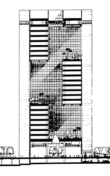
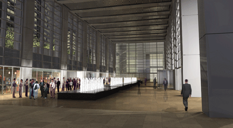
Recent innovations in high-rise architecture around the world epitomize the problems and shortcomings in the way designers approach the city, as well as their achievements. Generous sky-gardens and souring atria have become a common feature of office towers since SOM (Figure 2), Norman Foster (Figure 3) and Ken Yeang (Figure 4) led the way, raising the ground plane and opening up the interiors of tall buildings with semi-public spaces. Contrary to the stereotypical pictures presented by his critics, Foster also succeeded in extending and enhancing the public realm in high-rise architecture as well as in their civic buildings (Figure 5), creating popular plazas and 'urban rooms' around the base of his office towers, as well as in their upper levels. Introducing a whole vocabulary for greening skyscrapers, Yeang also argued for 'vertical urban design' as a field in itself, opening up a whole new way of thinking about cities.
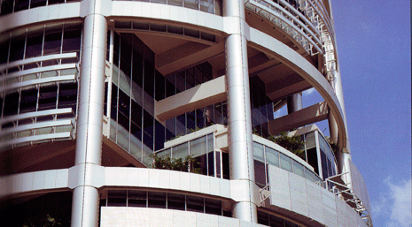
Inventive as these designs are, they remain tightly constrained by the vertical dimension and by their limited plot sizes and regulatory envelopes. Echoing the science fiction fantasies of the early twentieth century and the megastructure projects by Archigram and other avant-garde designers in the 1960s, a new tower type emerged at the turn of the millennium in which two or more structures are linked together at their upper levels by bridges and other spatial elements. The first and most familiar of these - the twin Petronas Towers in Kuala Lumpur by Cesar Pelli - are linked by a simple bridge, providing communication and alternative escape routes between the two structures. The more daring designs, like United Architects' entry for the World Trade Centre competition (Figure 6), and Steven Holl's Linked Hybrid Building in Beijing (Figure 7), join several tall buildings together with multifunctional public 'skyways'. The CCTV building in Beijing by OMA and Arup (Figure 8) also melds both horizontal and vertical elements into one spatial and structural continuum, while the Museum Plaza in Louisiana by REX features a raised slab of space housing a complete museum of art supported by several slim towers, arranged much like the seat and legs of a chair (Figure 9).
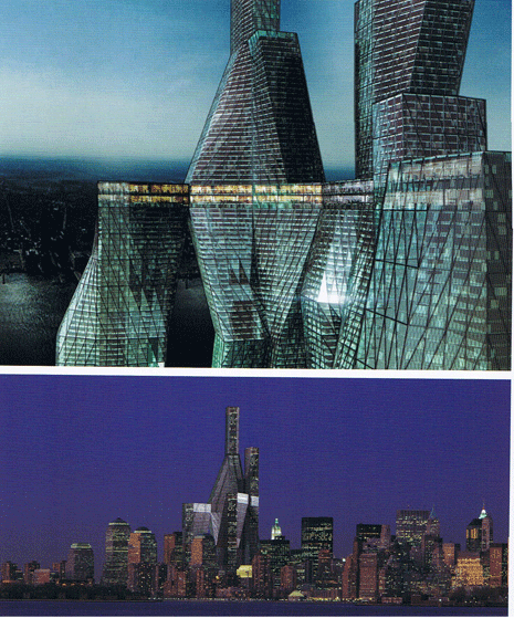
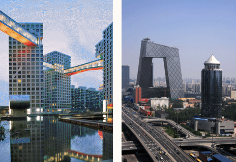
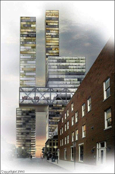
All of these projects, none of which was conceivable without the new digital technologies of production, give new meaning to the horizontal dimension in high-rise architecture. However, for all their innovations, the vision they offer of new urban forms and spaces is at best a partial one. They appear primarily as giant sculptured objects in their urban surroundings while the external spaces between the different elements of the composition have little or no definition or character of their own. Similarly, attempts to revive the Corbusian idea of a 'vertical garden city', like Mori's project for Tokyo, repeat the same tired formula of separate towers set in open parks. The idea of a genuine three-dimensional urban topology that might create elevated spaces of equivalent character and variety to those found in any great city at street level remains a compelling but elusive prospect.
The Vertical Architecture STudio
Though Howard's original vision may have been distorted beyond all recognition, the scope of his social agenda and commitment to safeguarding the landscape by concentrating urban growth around mass-transportation systems, are, if anything, more relevant today than they were in Howard's own age. Having accepted diminished professional roles and visions for decades in the face of rapacious economic and social forces, it may be time for architects and other designers to readjust their priorities and to broaden their horizons once again. Understandably, architects have abandoned the flawed urban visions of the past century to focus on the new technologies of production and other more immediate issues. However, having now finally mastered the 'how' of production in the digital age, designers need to refocus on the 'what', and to re-imagine the shape of the modern city to meet the urgent challenges of this century.
With this goal in mind, the Vertical Architecture STudio © (VAST) was created by the author as a focus for research in new forms of high-rise architecture and urban design. Beginning in 1994 as a studio project at the University of Nottingham, UK, VAST was created in its present itinerant form in 2006 at the Faculty of Architecture, University of Sydney (USYD). It has since been run at architecture schools at the University of Lincoln Nebraska (UNL) and most recently at the University of New South Wales (UNSW), also in Sydney, where it was offered in the graduate program. In line with current strategies of urban densification all of the projects carried out so far within the VAST program have been located on large central urban sites adjacent to or close by railways and other mass transit systems, the size of which demand appropriate large-scale solutions. In all cases, plans for high-density redevelopment on the same sites already exist and may, as in the first project in Sydney, even be under construction at the time, affording valuable sources of information and benchmarks for the students' work without inhibiting their own approaches. Given the complexity of the designs, of which most students have had little or no prior experience, teamwork is mandatory for all projects.
Overriding any differences in their location, all VAST programs are based on a common set of principles for designing a prototypical Vertical Garden City, based upon a new urban topology. Beyond these principles, generic solutions, structural logic and energy saving features are favored over idiosyncratic form making, though this has not excluded non-orthogonal geometries, or iconic forms. Crucially, depending on the scope offered by site and program, students are encouraged to treat both horizontal and vertical spatial dimensions as having potentially equal significance above ground level. Similarly, particular attention is directed to the creation of open and enclosed spaces and activities that improve the quality of life at elevated levels as well as on the ground.

Two schemes from the first VAST program at USYD illustrate some of the key issues at stake. The oddly shaped site – the smallest of any VAST program to date but by no means the least difficult - consisted of two linked parcels of land on opposite sides of a block in the heart of Sydney's commercial and entertainment centre.
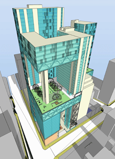
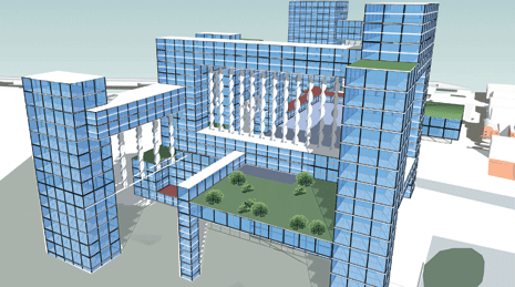
Inspired by the bifurcated shape of the site, one group of students designed two towers asymmetrically joined at their apex, inverting the conventional tower and podium arrangement and opening up a large plaza beneath at street level (Figure 10). Another group focused on creating a 'secondary ground' at mid-level, carefully arranging adjacent structures so as to create large sheltered open spaces at both upper and lower levels (Figure 11). While the first scheme derives its form from the unique features of its site and leans towards the sculptured qualities of some of the above precedents, the second scheme yields generic urban solutions indicative of a 3D spatial matrix that can be readily extended and adapted to other, much larger sites.
Since 2008 a substantial level of urban agriculture has also been included in VAST projects. Already threatened in many countries by drought and reduced capacity, the effects of global warming on food production around the world are likely to hit consumers especially hard in the future, as souring fuel prices in turn raise the cost of importing food from distant sources overseas, which may themselves be sorely stressed by climate change. However, as with trigeneration and other forms of distributed energy, the benefits of closing distances between the points of production and consumption are applicable to any part of the world, as in North America, where great distances typically separate consumers from producers. As fuel costs rise and alternative sources shrink, the economics of producing food within cities on expensive sites will also doubtless become more favorable in future. The growing use of intensive farming techniques such as hydroponics and aeroponics, which greatly increase the efficiency of food production whilst reducing the amount of water and space required, will also ultimately help to lower costs. However, aside from subsidized or experimental projects, the high capital investment entailed in building purpose-designed structures would appear to limit the development of stand-alone vertical farms in cities for some time yet.
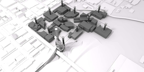
The approach to vertical farming in VAST projects has instead been to create flexible spaces for food production within large scale, mixed-use developments where opportunities exist for offsetting the higher costs of providing space for one function against the lower costs of another. This has been combined with on-site systems of water collection and power generation, including, as with some of the UNL and UNSW projects, integrated wind turbines. One team at UNL, for example, capitalized on the favourable conditions in Nebraska for wind power - the state is proudly described locally as the future 'Saudi Arabia of wind power' - filling open spaces between the vertical elements of their design with large arrays of vertical axis turbines, or 'wind harps' (Figure 12). Another UNL team proposed a regular infrastructure of farming towers and wind-turbines combined with multi-functional blocks of space on the city grid that could be extended throughout Lincoln (Figure 13).
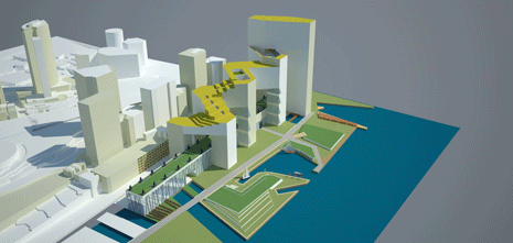
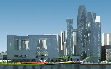
The most recent VAST programs at UNSW were also in many respects the most challenging and fruitful of the series. The waterfront site in the Barangaroo precinct of Sydney Harbour is the largest brownfield site to be developed in the city since the Olympic Park. Focusing on the blocks designated for high-rise development, which were treated as one site, students were invited to freely interpret planning guidelines and to explore alternative models for a Vertical Garden City. Following the design principles established in previous VAST programs, in most cases, the horizontal links between the vertical elements of the design acquired an importance and life of their own. One design consisted of a series of towers linked at both upper and lower levels zig-zagging either side of a long, ground based element surmounted by an elevated public park (Figure 14). Another scheme included both medium rise and high-rise structures, the first consisting of a "Chinese dragon" of linked offices and apartments and the other a cluster of linked, twisting towers of varying heights (Figure 15). Based on a regular hexagonal geometry, yet another design exploits the close visual and spatial relationships between linked structures to create a rich matrix of elevated spaces (Figures 16 & 17). All schemes include a generous amount of space for food production, as required in the project guidelines.
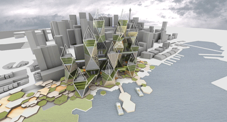
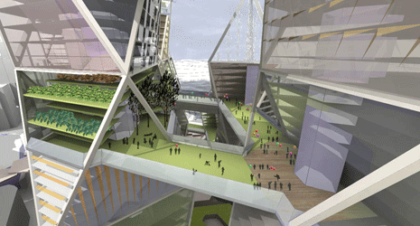
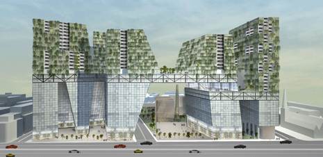
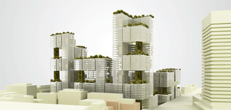
Some, like the UNL scheme described above, also take advantage of the favourable wind conditions on the exposed waterfront site and include large arrays of integrated wind turbines in their designs - shaped in the last design like triangular sails, reflecting the metaphorical associations of the Sydney Opera House in another part of the Harbour. The last VAST program at UNSW was based on a 6 hectare brownfield site close to Central Station, Sydney's main transport hub, currently being developed according to a masterplan by Foster + Partners. Adding to VAST's growing repertoire of new urban topological solutions, one radical scheme proposed a dramatic series of elevated apartments resembling a series of green ‘hills and valleys' supported by glazed offices below, with a continuous public concourse running around the whole complex at mid-level (Figure 18). Another consisted entirely of alternating 'L' shaped, mixed-use elements creating elevated gardens at intermediate levels around well-ventilated and lit atria (Figure 19).
Expansion of the public realm
The unusual nature of these designs has in turn thrown up new questions concerning the nature and propriety of future urban topologies of this kind. Nolli's famous figure-ground map of Rome, which was such an important influence on designers and theorists like Colin Rowe in past years, is an inadequate model for spatial relationships where what happens on the ground plane no longer provides an accurate guide to the spaces above. Digital movies, which unlike still images incorporate the vital time dimension, proved to be the most, and perhaps only reliable guide to the intended dynamic spatial experience. Similarly, moving through a maze of spaces where each junction or node offers a potential choice of moving up or down as well as in any other direction may be better likened to negotiating one's way through cyberspace from one multi-choice website to another rather than to any conventional urban experience.
However, the future development and success of the Vertical Garden City model may ultimately depend on a substantial expansion of the public urban realm above ground into hitherto wholly private territory. Already shrinking fast at ground level, the problem of extending the commons is compounded many times over above ground where private ownership and control of both habitable spaces and movement systems is generally total.
What chance then, for viable public spaces and amenities within an urban topology extended in all directions, as proposed in the above projects? Unlikely as it might have seemed until now, the seismic effects of climate change and the global financial crisis have combined to create a potentially new situation where, not only is it plausible to posit major extensions of public responsibility in all aspects of life, but also to view a major shift in priorities from private to public interests as an urgent necessity, if not a matter of actual survival. It is not unrealistic, therefore, to imagine a Vertical Garden City in which the responsibility for the construction and maintenance of the infrastructure and shared spaces above ground is retained by public authorities, just as the streets, pavements and buried services at ground level are presently financed and maintained by tax funded bodies and services or subcontracted out as appropriate. In this respect, the effect of food and water shortages on the future growth and form of cities as current sources are impacted by climate change may also turn the economic and political tide decisively in favour of vertical farming, compelling urban authorities to make space for and to control food production in cities to ensure adequate supplies. Factories of all kinds have always been accepted as an integral part of urban economies, made even more acceptable as neighbors now by the growth of clean industries. It would seem only a short matter of time before intensive forms of local food production also assume their place at literally all levels in the healthy life and economic wellbeing of cities.
In sum, there has never been a better time to re-evaluate the relevance of Howard's original work and intentions. While the two dimensional physical plan may be outdated, Howard's assertion of public and professional responsibility for the shape and quality of urban life is as urgently needed now as it ever was.

Maui's Vacation Rental Debate Turns Ugly
Verbal attacks, misinformation campaigns and fistfights plague a high-stakes debate to convert thousands of vacation rentals into long-term housing.

Planetizen Federal Action Tracker
A weekly monitor of how Trump’s orders and actions are impacting planners and planning in America.

San Francisco Suspends Traffic Calming Amidst Record Deaths
Citing “a challenging fiscal landscape,” the city will cease the program on the heels of 42 traffic deaths, including 24 pedestrians.

Defunct Pittsburgh Power Plant to Become Residential Tower
A decommissioned steam heat plant will be redeveloped into almost 100 affordable housing units.

Trump Prompts Restructuring of Transportation Research Board in “Unprecedented Overreach”
The TRB has eliminated more than half of its committees including those focused on climate, equity, and cities.

Amtrak Rolls Out New Orleans to Alabama “Mardi Gras” Train
The new service will operate morning and evening departures between Mobile and New Orleans.
Urban Design for Planners 1: Software Tools
This six-course series explores essential urban design concepts using open source software and equips planners with the tools they need to participate fully in the urban design process.
Planning for Universal Design
Learn the tools for implementing Universal Design in planning regulations.
Heyer Gruel & Associates PA
JM Goldson LLC
Custer County Colorado
City of Camden Redevelopment Agency
City of Astoria
Transportation Research & Education Center (TREC) at Portland State University
Jefferson Parish Government
Camden Redevelopment Agency
City of Claremont


