


With high development occurring in India, new mapping technologies can greatly help smart growth in the burgeoning country.
"This evolution in mapping has the potential to influence a much more significant and democratic process of urban design. Municipal agencies could collaborate with design professionals in establishing a simple and transparent process of uploading all upcoming urban design proposals onto dedicated websites.
Using satellite maps of Indian cities as a base, and layering proposed civic projects–new transport links, restoration and conservation of historic neighborhoods, landscape proposals for parks, changes in land use and zoning–over them, would enable a deeper understanding of the planning process. If coordinated efficiently among various stakeholders, this evolving documentation might reduce the redundancy of successive excavations of the same streets by the plethora of civic agencies."
FULL STORY: Urban Journal: Mapping the City

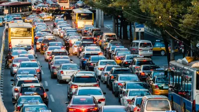
Cities Have Tried to Rein in Cars, and the Results Have Been Mixed
Vehicle pollution is making cities around the world unlivable. Some cities have taken steps to curb auto use and emissions, with varying levels of success.

Visualizing Worst-Case Scenario Sea Level Rise on the Texas Coast
Much of the state political leadership in Texas has been slow to accept the existence of climate change, much less the role of the state's economy, land use, and infrastructure planning in exacerbating the crisis. Maybe this will help wake them up?
Smog So Bad United Airlines Won't Fly There
It's not the poor visibility but the air quality, ten times worse than Beijing, that has caused the airline to stop flying to New Delhi.

Maui's Vacation Rental Debate Turns Ugly
Verbal attacks, misinformation campaigns and fistfights plague a high-stakes debate to convert thousands of vacation rentals into long-term housing.

Planetizen Federal Action Tracker
A weekly monitor of how Trump’s orders and actions are impacting planners and planning in America.

In Urban Planning, AI Prompting Could be the New Design Thinking
Creativity has long been key to great urban design. What if we see AI as our new creative partner?

King County Supportive Housing Program Offers Hope for Unhoused Residents
The county is taking a ‘Housing First’ approach that prioritizes getting people into housing, then offering wraparound supportive services.

Researchers Use AI to Get Clearer Picture of US Housing
Analysts are using artificial intelligence to supercharge their research by allowing them to comb through data faster. Though these AI tools can be error prone, they save time and housing researchers are optimistic about the future.

Making Shared Micromobility More Inclusive
Cities and shared mobility system operators can do more to include people with disabilities in planning and operations, per a new report.
Urban Design for Planners 1: Software Tools
This six-course series explores essential urban design concepts using open source software and equips planners with the tools they need to participate fully in the urban design process.
Planning for Universal Design
Learn the tools for implementing Universal Design in planning regulations.
planning NEXT
Appalachian Highlands Housing Partners
Mpact (founded as Rail~Volution)
City of Camden Redevelopment Agency
City of Astoria
City of Portland
City of Laramie