


The city of Pittsburgh has released a new plan focusing on revitalizing the Allegheny Riverfront, with proposed new housing, retail and public spaces.
The plan hopes to create a family-friendly neighborhood along the riverfront that will help lure people into the city.
"The corridor has vast amounts of vacant and underutilized property and a poor transportation network and does not capitalize on its proximity to the river, said the report by a consulting team led by Perkins Eastman Associates. The document follows nearly two years of studies and meetings with property and business owners, residents, community leaders and nonprofit organizations.
'The Allegheny Riverfront Vision, through the feedback of hundreds of citizens, has assessed the potential of some of Pittsburgh's most exciting riverfront neighborhoods,' Mr. Ravenstahl said in a press release. 'With this road map now in place, Pittsburgh has the once-in-a-lifetime opportunity to enhance urban communities like the Strip and Lawrenceville in ways that will create more jobs, attract new residents and reconnect the neighborhoods to our riverfronts.'"
FULL STORY: Mayor unveils vision for Allegheny Riverfront

Economic Development in Eagle, CO: A Riverfront Park and Whitewater Play Area
A sure way to turn out the vote in Eagle, Colorado: hold an election asking for a new sales tax to fund a whitewater play park on the local river. Voters overwhelmingly supported the project.
Riverfront Revitalization Rolls On in Pittsburgh
A recent article revisits the accomplishments of the Pittsburgh over the past 15 years in revitalizing the waterfronts of the Monongahela, Allegheny and Ohio rivers.
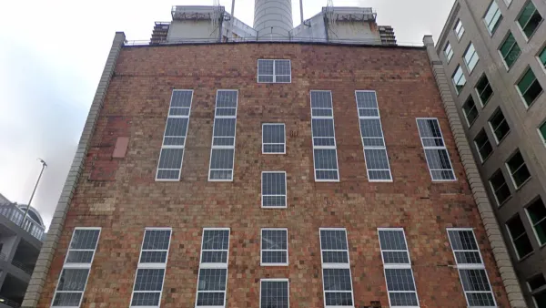
Defunct Pittsburgh Power Plant to Become Residential Tower
A decommissioned steam heat plant will be redeveloped into almost 100 affordable housing units.

Maui's Vacation Rental Debate Turns Ugly
Verbal attacks, misinformation campaigns and fistfights plague a high-stakes debate to convert thousands of vacation rentals into long-term housing.

Planetizen Federal Action Tracker
A weekly monitor of how Trump’s orders and actions are impacting planners and planning in America.

San Francisco Suspends Traffic Calming Amidst Record Deaths
Citing “a challenging fiscal landscape,” the city will cease the program on the heels of 42 traffic deaths, including 24 pedestrians.

Defunct Pittsburgh Power Plant to Become Residential Tower
A decommissioned steam heat plant will be redeveloped into almost 100 affordable housing units.

Trump Prompts Restructuring of Transportation Research Board in “Unprecedented Overreach”
The TRB has eliminated more than half of its committees including those focused on climate, equity, and cities.

Amtrak Rolls Out New Orleans to Alabama “Mardi Gras” Train
The new service will operate morning and evening departures between Mobile and New Orleans.
Urban Design for Planners 1: Software Tools
This six-course series explores essential urban design concepts using open source software and equips planners with the tools they need to participate fully in the urban design process.
Planning for Universal Design
Learn the tools for implementing Universal Design in planning regulations.
Heyer Gruel & Associates PA
JM Goldson LLC
Custer County Colorado
City of Camden Redevelopment Agency
City of Astoria
Transportation Research & Education Center (TREC) at Portland State University
Jefferson Parish Government
Camden Redevelopment Agency
City of Claremont