


Next American City talks with urban designer Mike Lydon about opening streets to people and closing streets to cars in this second of a two-part conversation.
Lydon is the founding principal of The Street Plans Collaborative, an urban planning, advocacy, and design firm that focuses on open streets projects and bicycle planning.
"Next American City: What's your view on shutting down the roads that surround a park, or shutting down a stretch of highway, as opposed to the connecting routes that you've seen elsewhere?
Mike Lydon: We've researched all types of routes. I think your answer really depends on what the goal of the initiative is. If it's the Ottawa, Canada – or the "parkway" model – which is closing your highway or river drive or roads within a park, then that's clearly for transportation and nice accessibility within the park itself, and its more purely recreational. If that's your only intent, then that's model is great.
But If you have a much larger idea in mind – if you're trying to get people to neighborhoods, have a cultural, social, economical, and political impact – then you really do have to think about using the more Bogotá, or we call it the "Cleveland" model or the "San Francisco" model, where cities really activate the public space to become in a way the linear playground for people."
FULL STORY: Part Two: Bike + Planning Talk With Mike Lydon

Open Streets Events Enjoy Coast-to-Coast Popularity
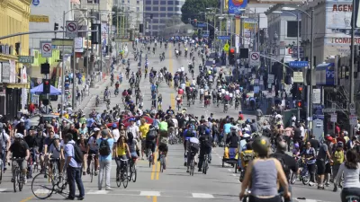
New York City and San Jose have expanded or added rules that temporarily close some of their streets to automobile traffic. This continues a string of successes for the open streets movement.
Open Street Events Around the World
Inspired by the ciclovías of Bogotá, Colombia, open street events are growing in popularity around the world. Here’s a survey of nine events from around the world that close streets to cars and open them up to humans.
Bikes to Get Buck in New Portland Budget
Portland Mayor Sam Adams has pledged to increase the amount of money dedicated to bicycle planning and bicycle infrastructure from 4% to 17% in the city's next budget.

Maui's Vacation Rental Debate Turns Ugly
Verbal attacks, misinformation campaigns and fistfights plague a high-stakes debate to convert thousands of vacation rentals into long-term housing.

Planetizen Federal Action Tracker
A weekly monitor of how Trump’s orders and actions are impacting planners and planning in America.

In Urban Planning, AI Prompting Could be the New Design Thinking
Creativity has long been key to great urban design. What if we see AI as our new creative partner?

Cal Fire Chatbot Fails to Answer Basic Questions
An AI chatbot designed to provide information about wildfires can’t answer questions about evacuation orders, among other problems.

What Happens if Trump Kills Section 8?
The Trump admin aims to slash federal rental aid by nearly half and shift distribution to states. Experts warn this could spike homelessness and destabilize communities nationwide.

Sean Duffy Targets Rainbow Crosswalks in Road Safety Efforts
Despite evidence that colorful crosswalks actually improve intersection safety — and the lack of almost any crosswalks at all on the nation’s most dangerous arterial roads — U.S. Transportation Secretary Duffy is calling on states to remove them.
Urban Design for Planners 1: Software Tools
This six-course series explores essential urban design concepts using open source software and equips planners with the tools they need to participate fully in the urban design process.
Planning for Universal Design
Learn the tools for implementing Universal Design in planning regulations.
Appalachian Highlands Housing Partners
Gallatin County Department of Planning & Community Development
Heyer Gruel & Associates PA
Mpact (founded as Rail~Volution)
City of Camden Redevelopment Agency
City of Astoria
City of Portland
City of Laramie