


Researchers are working on technology to help create 3D models of buildings and places by using large collections of digital photos.
With technology that processes huge amounts of digital image data, researchers at the University of Washington and Cornell University are able to quickly create 3D representations of buildings, neighborhoods and eventually entire cities. The technology is similar to a Microsoft application called Photosynth, but takes the process steps further.
"Photosynth collections are generally limited to dozens or hundreds of photos. The researchers wanted to push - or 'scale' - their technology to be able to handle tens of thousands or even millions of photos. They also wanted to use computer processing power to transform the photos into true three-dimensional images, or what they refer to as a 'dense point cloud.'
The visualization technology is already able to quickly process large collections of digital photos of an object like a building and render ghostly and evocative three-dimensional images. To do this they use a three-stage set of algorithms that begins by creating a 'sparse point cloud' with a batch of photos, renders it as a denser image, capturing much of the original surface texture of the object, and then renders it in three dimensions."
FULL STORY: Computers Turn Flat Photos into 3-D Buildings


Coronavirus Shuts Down Food Processing Plant as President Pushes Reopening Economy
As President Donald Trump eyes May 1 for "opening up states," he might want to look at states that never shut down businesses to understand his public health advisor's warning that "the virus makes the timeline."
How Zillow's Approach to Data Reshaped the Real Estate Market
Zillow's chief analytics officer and chief economist offers insight into the company's approach to data, models, and the real estate market.
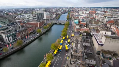
Take a LiDAR Tour of Dublin
The potential of Light Detection and Ranging (LiDAR) data to redefine mapping and modeling will be on display in the city of Dublin, Ireland, after NYU researchers released the largest ever LiDAR data set.

Maui's Vacation Rental Debate Turns Ugly
Verbal attacks, misinformation campaigns and fistfights plague a high-stakes debate to convert thousands of vacation rentals into long-term housing.

Planetizen Federal Action Tracker
A weekly monitor of how Trump’s orders and actions are impacting planners and planning in America.

In Urban Planning, AI Prompting Could be the New Design Thinking
Creativity has long been key to great urban design. What if we see AI as our new creative partner?

San Francisco Mayor Backtracks on Homelessness Goal
Mayor Dan Lurie ran on a promise to build 1,500 additional shelter beds in the city, complete with supportive services. Now, his office says they are “shifting strategy” to focus on prevention and mental health treatment.

How Trump's HUD Budget Proposal Would Harm Homelessness Response
Experts say the change to the HUD budget would make it more difficult to identify people who are homeless and connect them with services, and to prevent homelessness.

The Vast Potential of the Right-of-Way
One writer argues that the space between two building faces is the most important element of the built environment.
Urban Design for Planners 1: Software Tools
This six-course series explores essential urban design concepts using open source software and equips planners with the tools they need to participate fully in the urban design process.
Planning for Universal Design
Learn the tools for implementing Universal Design in planning regulations.
Gallatin County Department of Planning & Community Development
Heyer Gruel & Associates PA
JM Goldson LLC
Mpact (founded as Rail~Volution)
City of Camden Redevelopment Agency
City of Astoria
Jefferson Parish Government
Camden Redevelopment Agency
City of Claremont