


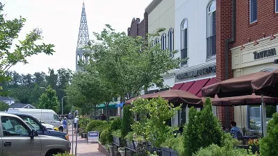
Orenco Station in Portland, OR shows that traditional neighborhood development (TND) can decrease car use and encourage walking, according to a new study.
"The study was based on a door-to-door survey of four neighborhoods in the Portland, Oregon, area. One was a conventional suburb in Beaverton, Oregon. Two were neighborhoods in Portland with differing physical characteristics and histories. The last was Orenco Station, one of the best-known new urban developments in the Northwest, with approximately 1,850 housing units and a town center that includes 68,000 square feet of ground-floor commercial space on a total of 190 acres.
The physical design of Orenco Station, with its pedestrian-friendly network of streets, small parks and public spaces, differs substantially from the other neighborhoods studied - especially the conventional suburb containing large lots, cul-de-sacs, and few sidewalks. Data was collected from Orenco Station in 2002 and 2007, offering insights into how attitudes change in a new urban community over time. A paper that fully describes the study will be published in an upcoming urban research journal."
Among the findings: Ten times more Orenco Station residents regularly walk to a store than do the inhabitants of the Beaverton suburb. "This achievement likely contributes not only to environmental sustainability but to personal health," the researchers note.
Thanks to Renee Brutvan
FULL STORY: New urban community promotes social networks and walking


A Primer on Suburban Urbanism
How one master-planned development used lower-density urbanism principles to build a community focused on affordability, sustainability, and conservation.
A ‘New Urbanism’ Travelogue
I visited three New Urbanist developments in North Carolina. Here's what I liked, what I didn't like, and what I learned.
Urban Villages: The Key to Sustainable Community Economic Development
Compact, walkable urban villages support sustainable economic development by reducing transportation costs, leaving residents with more money to spend on local goods, and by creating more efficient and attractive commercial districts.

Maui's Vacation Rental Debate Turns Ugly
Verbal attacks, misinformation campaigns and fistfights plague a high-stakes debate to convert thousands of vacation rentals into long-term housing.

Planetizen Federal Action Tracker
A weekly monitor of how Trump’s orders and actions are impacting planners and planning in America.

San Francisco Suspends Traffic Calming Amidst Record Deaths
Citing “a challenging fiscal landscape,” the city will cease the program on the heels of 42 traffic deaths, including 24 pedestrians.

Bend, Oregon Zoning Reforms Prioritize Small-Scale Housing
The city altered its zoning code to allow multi-family housing and eliminated parking mandates citywide.

Amtrak Cutting Jobs, Funding to High-Speed Rail
The agency plans to cut 10 percent of its workforce and has confirmed it will not fund new high-speed rail projects.

LA Denies Basic Services to Unhoused Residents
The city has repeatedly failed to respond to requests for trash pickup at encampment sites, and eliminated a program that provided mobile showers and toilets.
Urban Design for Planners 1: Software Tools
This six-course series explores essential urban design concepts using open source software and equips planners with the tools they need to participate fully in the urban design process.
Planning for Universal Design
Learn the tools for implementing Universal Design in planning regulations.
planning NEXT
Appalachian Highlands Housing Partners
Mpact (founded as Rail~Volution)
City of Camden Redevelopment Agency
City of Astoria
City of Portland
City of Laramie