


Linden Labs, creator of Second Life, has awarded a Linden Prize to Studio Wikitecture for their WikiTree project. The online collaboration uses the virtual world "to harness a groups collective intelligence in designing architecture."
"To help aggregate the contributions of such a disparate range of individuals, we developed what could best be described as a 3D-Wiki plugin for Second Life. The Wiki-Tree, as we called it, worked very much like a conventional Wiki, but instead of tracking text documents in a linear history, this 3D-Wiki tracked versions of digital models and saved them within a continually evolving 3-dimensional collective 'mind map'.
When a contributor used the inworld interface to upload their design iteration, a new leaf grew out of the existing 'Canopy'. For every leaf created inworld, a corresponding section was also created on an external website. Besides storing the individual design iterations, the 3-dimensional Canopy was able to visually convey how the different ideas, submitted by different contributors, grew and evolved from on another. Popular designs in the canopy turned green, and the less popular designs turned red and were automatically pruned.
To review the various designs, members could simply click the individual 'leaves' and the design contained within would rez itself out on the parcel. Members were also able to upload snapshots, vote and comment on their fellow contributor's designs."
FULL STORY: Studio Wikitecture: Open Architecture Challenge


Montana Land Use Reform Overhauls Public Participation Rules
In a bid to streamline housing permits, new state legislation limits public input to the land use planning stage.
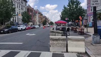
The Slow Streets Reckoning
Slow streets programs provided a quick short-term solution and paved the way for some permanent street closures and realignments. Now, these programs are getting a second look as community groups react to the changes.

Pandemic Planning Must Reconcile With the Inequities of the Past
The ongoing debate about the role of marginalized communities in the emergency planning programs of the pandemic has now been detailed on the pages of the New York Times.

Planetizen Federal Action Tracker
A weekly monitor of how Trump’s orders and actions are impacting planners and planning in America.

Maui's Vacation Rental Debate Turns Ugly
Verbal attacks, misinformation campaigns and fistfights plague a high-stakes debate to convert thousands of vacation rentals into long-term housing.

Restaurant Patios Were a Pandemic Win — Why Were They so Hard to Keep?
Social distancing requirements and changes in travel patterns prompted cities to pilot new uses for street and sidewalk space. Then it got complicated.

Charlottesville Temporarily Has No Zoning Code
A judge ordered the Virginia city to throw out its newly revised zoning code, leaving permitting for new development in legal limbo.

In California Battle of Housing vs. Environment, Housing Just Won
A new state law significantly limits the power of CEQA, an environmental review law that served as a powerful tool for blocking new development.

Boulder Eliminates Parking Minimums Citywide
Officials estimate the cost of building a single underground parking space at up to $100,000.
Urban Design for Planners 1: Software Tools
This six-course series explores essential urban design concepts using open source software and equips planners with the tools they need to participate fully in the urban design process.
Planning for Universal Design
Learn the tools for implementing Universal Design in planning regulations.
Heyer Gruel & Associates PA
JM Goldson LLC
Custer County Colorado
City of Camden Redevelopment Agency
City of Astoria
Transportation Research & Education Center (TREC) at Portland State University
Jefferson Parish Government
Camden Redevelopment Agency
City of Claremont