


Turning a New York landfill into a park may just reorganize the way people think about public parks in America.
"The sky, when viewed from atop a twenty-story heap of slowly decomposing garbage-the so-called South Mound, a Tribeca-size drumlin surrounded by other trash mounds, some as long as a mile-is the kind of big blue that you expect to see somewhere else, like the middle of Missouri. It's a great wide-open bowl, fringed with green hills (some real, some garbage-filled) that are some of the highest points on the Atlantic seaboard south of Maine."
"But as you look a little longer, it's definitely not a Missouri view, and the unmistakable landmarks come into focus: a tower on the Verrazano-Narrows Bridge, a span of the Outerbridge Crossing, and, on Coney Island, the very top of the parachute jump. In the foreground, trucks enter the landfill, climbing the mounds and dumping clean soil over not-so-clean soil. It's all part of a radical plan to turn Fresh Kills landfill into Fresh Kills Park, with mountain bikers and kayakers and ballplayers sharing 2,315 acres of open space with restored maritime forests, with chestnut trees dotting dry prairies, with new or revived sweet-gum swamps, maybe a fox scooting through persimmon copses or a deer through a new birch thicket."
"The composer of this massive reclamation project is James Corner, the landscape architect best known in New York as the designer of the High Line. When that abandoned elevated railway turned inner-city park opens its first section this winter, its industrially influenced meadows, interstitial urban prairies, and sundecks will bring Corner's firm, Field Operations, a new round of international attention. But as celebrated as the High Line will probably be, it is Field Operations' other New York park-the one that's bigger than lower Manhattan, and currently about the height of Mexico's Great Pyramid of Cholula-that may change people's ideas of what a park is all about."
FULL STORY: Wall-E Park


Transforming Landfills into Parks
Learn about eleven landfills that have been transformed into beautiful outdoor recreation spaces.
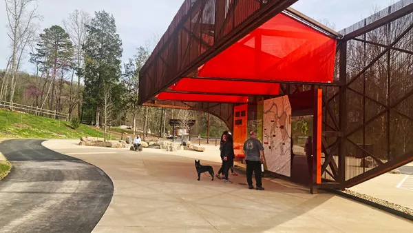
Baker Creek Pavilion: Blending Nature and Architecture in Knoxville
Knoxville’s urban wilderness planning initiative unveils the "Baker Creek Pavilion" to increase the city's access to green spaces.

‘Quiet Parks’ Highlight Importance of Silence for Public Health
The initiative recognizes parks and other areas that preserve natural quiet in a world full of noise pollution.

Planetizen Federal Action Tracker
A weekly monitor of how Trump’s orders and actions are impacting planners and planning in America.

Chicago’s Ghost Rails
Just beneath the surface of the modern city lie the remnants of its expansive early 20th-century streetcar system.

San Antonio and Austin are Fusing Into one Massive Megaregion
The region spanning the two central Texas cities is growing fast, posing challenges for local infrastructure and water supplies.

Since Zion's Shuttles Went Electric “The Smog is Gone”
Visitors to Zion National Park can enjoy the canyon via the nation’s first fully electric park shuttle system.

Trump Distributing DOT Safety Funds at 1/10 Rate of Biden
Funds for Safe Streets and other transportation safety and equity programs are being held up by administrative reviews and conflicts with the Trump administration’s priorities.

German Cities Subsidize Taxis for Women Amid Wave of Violence
Free or low-cost taxi rides can help women navigate cities more safely, but critics say the programs don't address the root causes of violence against women.
Urban Design for Planners 1: Software Tools
This six-course series explores essential urban design concepts using open source software and equips planners with the tools they need to participate fully in the urban design process.
Planning for Universal Design
Learn the tools for implementing Universal Design in planning regulations.
planning NEXT
Appalachian Highlands Housing Partners
Mpact (founded as Rail~Volution)
City of Camden Redevelopment Agency
City of Astoria
City of Portland
City of Laramie