


The New York Times surveys the end of every subway line in the city, from Ozone Park to Coney Island. At most stops, they find a gritty existence. A beautiful page of photos accompanies the article.
"At the city's often-threadbare fringes, there is an inescapable sense of lonesomeness. There might be a Last Stop Deli, a forlorn bar, a maintenance yard populated mostly by rows of empty trains. There is, surprisingly often, a cemetery.
Yet to visit all the system's extremities is to see that the last stop is not a single, monolithic place. There are subway lines that end, logically, where the city runs out of land; lines that end, anticlimactically, where builders ran out of money; even a few that fetch up in bustling downtowns of one sort or another. From the marshy lowlands of Tottenville to the lush hills of Riverdale to the ceaseless clangor of Flushing, the end of the line manages to take in the entire breadth of the city beyond Midtown Manhattan."
FULL STORY: Going to the End of the Line

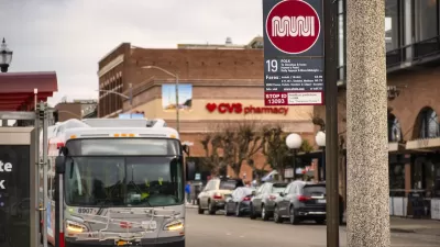
San Francisco Muni Sees Highest Ridership Since Start of Pandemic
The SFMTA is improving service at off-peak hours and on weekends to accommodate new travel patterns that rely less on weekday commuters. Ridership has increased accordingly.

D.C. Leads the Nation for Transit Recovery
Ridership on the region’s rail systems is rebounding faster than other major transit systems.

Subway Ridership Still Lagging as Cities Come Back to Life
While other aspects of urban life are starting to recover to pre-pandemic ‘normals,’ ridership on the nation’s subway systems is still well below average levels.

Maui's Vacation Rental Debate Turns Ugly
Verbal attacks, misinformation campaigns and fistfights plague a high-stakes debate to convert thousands of vacation rentals into long-term housing.

Planetizen Federal Action Tracker
A weekly monitor of how Trump’s orders and actions are impacting planners and planning in America.

In Urban Planning, AI Prompting Could be the New Design Thinking
Creativity has long been key to great urban design. What if we see AI as our new creative partner?

King County Supportive Housing Program Offers Hope for Unhoused Residents
The county is taking a ‘Housing First’ approach that prioritizes getting people into housing, then offering wraparound supportive services.

Researchers Use AI to Get Clearer Picture of US Housing
Analysts are using artificial intelligence to supercharge their research by allowing them to comb through data faster. Though these AI tools can be error prone, they save time and housing researchers are optimistic about the future.

Making Shared Micromobility More Inclusive
Cities and shared mobility system operators can do more to include people with disabilities in planning and operations, per a new report.
Urban Design for Planners 1: Software Tools
This six-course series explores essential urban design concepts using open source software and equips planners with the tools they need to participate fully in the urban design process.
Planning for Universal Design
Learn the tools for implementing Universal Design in planning regulations.
planning NEXT
Appalachian Highlands Housing Partners
Mpact (founded as Rail~Volution)
City of Camden Redevelopment Agency
City of Astoria
City of Portland
City of Laramie