


Officials in Miami-Dade County have just released their parks master plan, an ambitious proposal that looks to go beyond creating park space by redefining the region's public realm.
"Miami-Dade County on Friday will roll out an extraordinarily ambitious parks and open-space master plan that aims over the next half-century to re-green and reconnect a community that has spent much of the previous 50 years carving up and paving over the natural landscape."
"'This is probably the single most important thing that Miami-Dade Parks and Recreation has been involved in in decades,' said county parks director Jack Kardys. 'It really is about leaving a legacy for the community.'"
"The plan, approved last month by the County Commission, reaches well beyond traditional park concepts to what planners call 'the public realm' -- laying out new principles to guide not only how the county plans parks and public places, but also how it builds and designs streets and sidewalks to encourage more people to walk and bicycle. It calls for what amounts to a massive makeover of Miami-Dade's asphalt look and, planners hope, its increasingly congested quality of life."
"Among its most ambitious elements: a 40-mile-plus bikeable loop connecting Biscayne and Everglades national parks along Southwest 328th and 344th streets at the southern end of the county, and a vast north-to-south recreational and ecological zone along the eastern edge of the Everglades, most of it on land already under public control."
FULL STORY: Dade rolling out massive parks plan

Best Ideas of the Week
We all know there's a lot of planning going on around the world. Much of it is poor, short-sighted and generally just no good. But there are also some really great ideas being developed and adopted, and they should be considered by cities and communities all over the world as instructive examples of good planning. Here are what I think are some of the best ideas in urban planning from the last week.

Survey: US Public Spaces Not Meeting Community Needs
A lack of funding prevents many U.S. parks and public spaces from playing a more significant role in helping residents meet daily needs.
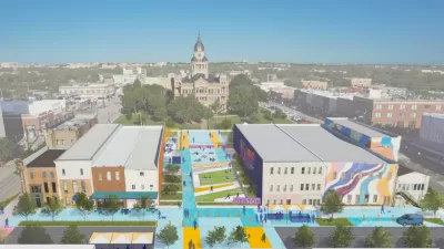
North Texas Town Launches Downtown Revitalization Plan
The Design Downtown Denton plan takes aim at improving walkability and highlighting the city’s historic assets.

Maui's Vacation Rental Debate Turns Ugly
Verbal attacks, misinformation campaigns and fistfights plague a high-stakes debate to convert thousands of vacation rentals into long-term housing.

Planetizen Federal Action Tracker
A weekly monitor of how Trump’s orders and actions are impacting planners and planning in America.

San Francisco Suspends Traffic Calming Amidst Record Deaths
Citing “a challenging fiscal landscape,” the city will cease the program on the heels of 42 traffic deaths, including 24 pedestrians.

Defunct Pittsburgh Power Plant to Become Residential Tower
A decommissioned steam heat plant will be redeveloped into almost 100 affordable housing units.

Trump Prompts Restructuring of Transportation Research Board in “Unprecedented Overreach”
The TRB has eliminated more than half of its committees including those focused on climate, equity, and cities.

Amtrak Rolls Out New Orleans to Alabama “Mardi Gras” Train
The new service will operate morning and evening departures between Mobile and New Orleans.
Urban Design for Planners 1: Software Tools
This six-course series explores essential urban design concepts using open source software and equips planners with the tools they need to participate fully in the urban design process.
Planning for Universal Design
Learn the tools for implementing Universal Design in planning regulations.
Heyer Gruel & Associates PA
JM Goldson LLC
Custer County Colorado
City of Camden Redevelopment Agency
City of Astoria
Transportation Research & Education Center (TREC) at Portland State University
Jefferson Parish Government
Camden Redevelopment Agency
City of Claremont