


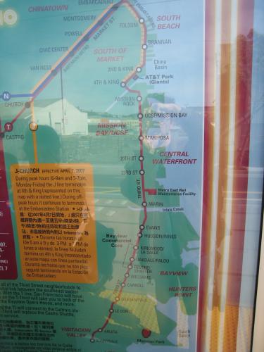
The family and I took a recreational ride on the newest light rail line in San Francisco today, the Muni train known as the T. It runs along the city's east-west spine, Market St., and then cuts south along the water of the bay, then inland and way, way south down Third Street—from the city's hottest under-construction neighborhood through the worst ghetto.As such, it's an interesting new ride in San Francisco. Some photos and observations after the jump.

The family and I took a recreational ride on the newest light rail line in San Francisco today, the Muni train known as the T. It runs along the city's east-west spine, Market St., and then cuts south along the water of the bay, then inland and way, way south down Third Street-from the city's hottest under-construction neighborhood through the worst ghetto.
As such, it's an interesting new ride in San Francisco. Some photos and observations after the jump.
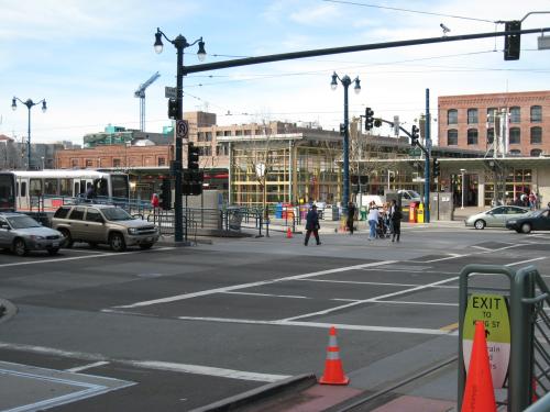
The line runs along existing rails until it reaches the newish Caltrain station a couple of blocks from PacBell Park. Then it turns south into a neighborhood called Mission Bay, which until just a couple years ago was warehouses, dilapidated industrial buildings, and port facilities.
The line and the ballpark:

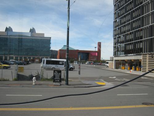
The Caltrain station:
I've only lived in San Fran for four years, but when I arrived Mission Bay was a bunch of under-construction high-end condo buildings along King Street (where a recreational vehicle park used to be, I'm told) and a driving range.
South of the ballpark-one of those beautiful downtown baseball stadiums built in the wake of the success of the one in Baltimore-was mostly parking. Acres and acres of parking. It's where Cirque du Soleil sets up the big tent when it's in town. But then the University of California at San Francisco decided to buid its big expansion there.
Actually I don't know what order all this happened in. I'm new in town. Clearly the folks who run the city decided that the Mission Bay neighborhood was the next big target for expansion, so they changed the zoning and started building the rail line.
UCSF campus, seen from the train:
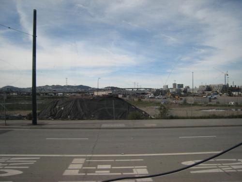
Empty Mission Bay:
Since the line opened in beta, on January 15, rides have been free. According to a couple of SF police officers I talked to-they were riding along as security-the trains are still having some issues timing their speed to take advantage of the traffic lights. The line is grade-separated from the street, but runs down the middle.
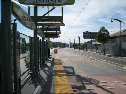
The stations are really just concrete outcroppings at the side of the tracks, but they're stylishly designed with wavy glass and roofs. There's a lot of placemaking going on along the route-I drove it four years ago, during construction, and it was a grim road of light industry storefronts and a few bars until hit got to Hunters Point, SF's predominantly African-American neighborhood. Now, around the stations, the streetlights have some fascia to match the stations. It's pretty.
A station:
Signage:
We got off the train and got on a northbound one around Cesar Chavez, at the southern end of Potrero Hill. Had to get the baby home for his nap. So I didn't see what the ride was like through Hunters Point. That part of town's always controversial-the idea of a ghetto doesn't fit too well with San Fran's sort of twee Painted Lady Victorians and anything-goes Lefty ideology. But it's one of the local green movement's talking points that the Hunters Point power station has been closed down. The amount it actually polluted is debatable, but cries of environmental justice won the day. Which is probably good, in the end.
I'm interested, though, in the construction of a new transit line that connects what is a frankly poor neighborhood to some of San Fran's wealthiest ones without even having to transfer. Usually that makes people in the wealthier neighborhoods nervous; I'm delighted that here it's a done deal. And even before the line opened, smart folks were buying houses and developable real estate along the route. It's good proof of transit as an economic engine.
Color me optimistic, but I'm hopeful that the T gets tons of ridership. Because it's also sort of a test case for the next light rail line the city wants to build-north from the financial district, through Chinatown. Now if they could just get the fare-readers on Muni, BART, and Alameda transit to read the same cards, I'd be a happy man....


Planetizen Federal Action Tracker
A weekly monitor of how Trump’s orders and actions are impacting planners and planning in America.

San Francisco's School District Spent $105M To Build Affordable Housing for Teachers — And That's Just the Beginning
SFUSD joins a growing list of school districts using their land holdings to address housing affordability challenges faced by their own employees.

Can We Please Give Communities the Design They Deserve?
Often an afterthought, graphic design impacts everything from how we navigate a city to how we feel about it. One designer argues: the people deserve better.

The EV “Charging Divide” Plaguing Rural America
With “the deck stacked” against rural areas, will the great electric American road trip ever be a reality?

Judge Halts Brooklyn Bike Lane Removal
Lawyers must prove the city was not acting “arbitrarily, capriciously, and illegally” in ordering the hasty removal.

Engineers Gave America's Roads an Almost Failing Grade — Why Aren't We Fixing Them?
With over a trillion dollars spent on roads that are still falling apart, advocates propose a new “fix it first” framework.
Urban Design for Planners 1: Software Tools
This six-course series explores essential urban design concepts using open source software and equips planners with the tools they need to participate fully in the urban design process.
Planning for Universal Design
Learn the tools for implementing Universal Design in planning regulations.
Borough of Carlisle
Smith Gee Studio
City of Camden Redevelopment Agency
City of Astoria
Transportation Research & Education Center (TREC) at Portland State University
City of Camden Redevelopment Agency
Municipality of Princeton (NJ)