


Thanks to Planetizen for asking me to participate in “Planetizen Interchange” with such a distinguished group. This is my first entry so to let you know a bit about me, I live in New Orleans, LA. I was displaced for 10 months to Houston, TX after Katrina destroyed my house, but I am back in New Orleans where I am a planning, zoning and land use consultant.
Thanks to Planetizen for asking me to participate in "Planetizen Interchange" with such a distinguished group. This is my first entry so to let you know a bit about me, I live in New Orleans, LA. I was displaced for 10 months to Houston, TX after Katrina destroyed my house, but I am back in New Orleans where I am a planning, zoning and land use consultant. I am also Chairman of the New Orleans City Planning Commission. To say the least, this is an interesting time to be a planner in New Orleans.
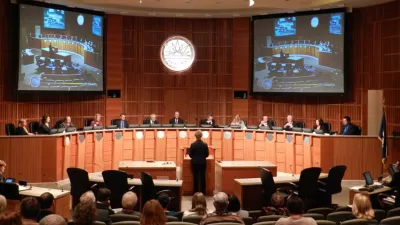
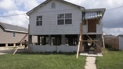
The big planning issue, maybe the only planning issue, in metro New Orleans these days is recovery after the devastation of Hurricane Katrina in August 2005. After 18 months, much of the City is still devastated – devastation that pictures and television news stories can't begin to accurately portray. By most estimates, less than half of the City's pre-Katrina population has returned. The recovery planning process has been extremely long and is a multi-headed beast. A "Citywide" or "Unified" plan, sponsored by the Rockefeller Foundation and others, is before the City Planning Commission for public hearings and a recommendation to the Council. That plan was to put together the goals, recommendations and recovery projects of several other processes and studies into one "unified" plan. A giant, maybe impossible, task. The plan has been criticized by some as fluff, praised by others because of the extraordinarily extensive public participation process.
There are many issues being debated here. Just to pick one for discussion, what is the balance between what the public wants and what professional planning analysis recommends, especially when the two are at odds? Is there a way to find a middle ground?

Is 'Hacking' a Planning Commission a Good Idea?
Does giving short shrift to grassroots tradition cut against the dynamics of community-based decision-making?
Adapting Building Codes to Natural Disasters Saves Billions
New research shows that modern building codes have prevented around $27 billion in damage from natural disasters between 2000 and 2016, yet many cities still operate under decades-old regulations.
The Compounding Dangers of the Virus and Natural Disasters
As Hurricane Laura intensified into a Category 4 storm, public officials had to make decisions about evacuation during a time of sheltering in place. Researchers at Texas A&M University developed a risk index to guide decisionmaking processes.

Maui's Vacation Rental Debate Turns Ugly
Verbal attacks, misinformation campaigns and fistfights plague a high-stakes debate to convert thousands of vacation rentals into long-term housing.

Planetizen Federal Action Tracker
A weekly monitor of how Trump’s orders and actions are impacting planners and planning in America.

San Francisco Suspends Traffic Calming Amidst Record Deaths
Citing “a challenging fiscal landscape,” the city will cease the program on the heels of 42 traffic deaths, including 24 pedestrians.

Defunct Pittsburgh Power Plant to Become Residential Tower
A decommissioned steam heat plant will be redeveloped into almost 100 affordable housing units.

Trump Prompts Restructuring of Transportation Research Board in “Unprecedented Overreach”
The TRB has eliminated more than half of its committees including those focused on climate, equity, and cities.

Amtrak Rolls Out New Orleans to Alabama “Mardi Gras” Train
The new service will operate morning and evening departures between Mobile and New Orleans.
Urban Design for Planners 1: Software Tools
This six-course series explores essential urban design concepts using open source software and equips planners with the tools they need to participate fully in the urban design process.
Planning for Universal Design
Learn the tools for implementing Universal Design in planning regulations.
Heyer Gruel & Associates PA
JM Goldson LLC
Custer County Colorado
City of Camden Redevelopment Agency
City of Astoria
Transportation Research & Education Center (TREC) at Portland State University
Jefferson Parish Government
Camden Redevelopment Agency
City of Claremont