


Learn how Maui County is integrating sea level rise and coastal threats into planning for and protecting its 65 beach parks.
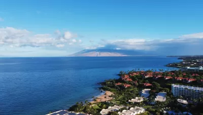
Maui is perhaps best known as a popular tourist destination. After all, the Hawaiian island is beloved for its world-famous beaches, the sacred ʻĪao Valley, views of humpback whales, farm-to-table cuisine, and the magnificent sunrise and sunset from Haleakalā. However, Maui is also facing some challenges related to climate change.
In this article, Maui County Department of Parks and Recreation (DPR) planners David Yamashita and Jen Maydan discuss an important project initiated in 2020 to assess the vulnerability of beach parks and facilities to flooding and land loss due to sea level rise and other threats and to identify adaptation strategies to address these threats. Completed with the assistance of Tetra Tech, Inc., the project consists of four phases: (1) identify the vulnerability rating for each park; (2) prepare six general strategies; (3) develop an interactive web-based app; and (4) prepare more detailed recommendations for parks that are particularly vulnerable to coastal threats in the short term.
The analysis generated a wealth of information about park vulnerability and adaptation responses, which varied by district. Most parks, about 60 percent, have a medium adaptation potential, while 20 percent have a high potential, and 20 percent have a low potential. Of the six adaptation strategies, “maintain facilities and monitor conditions” was recommended for 30 percent of the 65 parks. “Assess park viability based on future access” was the second most recommended strategy, which indicates that park access roads also are vulnerable to shoreline hazards. A key takeaway is that sea-level rise is a problem that affects the DPR and state and county departments, all of which will need to coordinate and collaborate.
For more information, please read the source article.
FULL STORY: Climate Change Is Now

How Cities Can Support Climate Adaptation
In the face of federal cuts to climate resilience funding, a panel at ULI’s Resilience Summit offered suggestions for maintaining managed retreat and other climate adaptation programs.

SoCal Leaders Debate Moving Coastal Rail Line
Train tracks running along the Pacific Ocean are in danger from sea level rise, but residents are divided on how to fix the problem.
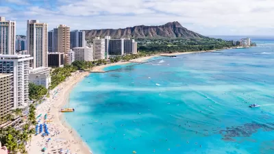
Rising Above: Innovative Solutions for Waikīkī’s Sea-Level Challenges
The University of Hawaiʻi at Mānoa’s award-winning Waikīkī sea-level rise adaptation project combines science, architecture, and community input to create scalable solutions for climate resilience and coastal flood mitigation.

Planetizen Federal Action Tracker
A weekly monitor of how Trump’s orders and actions are impacting planners and planning in America.

San Francisco's School District Spent $105M To Build Affordable Housing for Teachers — And That's Just the Beginning
SFUSD joins a growing list of school districts using their land holdings to address housing affordability challenges faced by their own employees.

Can We Please Give Communities the Design They Deserve?
Often an afterthought, graphic design impacts everything from how we navigate a city to how we feel about it. One designer argues: the people deserve better.

The EV “Charging Divide” Plaguing Rural America
With “the deck stacked” against rural areas, will the great electric American road trip ever be a reality?

Judge Halts Brooklyn Bike Lane Removal
Lawyers must prove the city was not acting “arbitrarily, capriciously, and illegally” in ordering the hasty removal.

Engineers Gave America's Roads an Almost Failing Grade — Why Aren't We Fixing Them?
With over a trillion dollars spent on roads that are still falling apart, advocates propose a new “fix it first” framework.
Urban Design for Planners 1: Software Tools
This six-course series explores essential urban design concepts using open source software and equips planners with the tools they need to participate fully in the urban design process.
Planning for Universal Design
Learn the tools for implementing Universal Design in planning regulations.
Borough of Carlisle
Smith Gee Studio
City of Camden Redevelopment Agency
City of Astoria
Transportation Research & Education Center (TREC) at Portland State University
City of Camden Redevelopment Agency
Municipality of Princeton (NJ)