


The Puget Sound region could benefit from zoning tweaks that would encourage more transit-oriented development and ‘gentle’ density increases, new research finds.
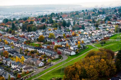
The Urban Institute’s Yonah Freemark, Lydia Lo, Olivia Fiol, Gabe Samuels, and Andrew Trueblood analyzed how changes to Seattle’s zoning code could stimulate more housing production, encourage transit-oriented development, and alleviate the region’s housing shortage.
According to the authors, when it comes to regional transit, “About one third of station-adjacent land is zoned for only single-family homes; almost 50 percent requires at least one parking spot per unit. Both zoning restrictions add to housing costs, making new construction more difficult and new homes more expensive.”
But there is an opportunity for the Puget Sound region, the authors argue. “With housing construction slowing in recent decades, policymakers can implement new land-use policies locally or statewide to accelerate construction, add space for residents, and reduce housing costs.”
The authors highlight key reforms that could help accelerate housing production in Seattle and elsewhere, including: permitting more high-density housing; allowing ‘missing middle’ housing types; and promoting two- to four-unit buildings to gently increase density and provide more housing options. “We also studied a fourth reform—legalizing apartment units on land now zoned only for commercial space—but found that it would have a limited impact on housing overall, because commercial-only zoning is rare in most of the areas near transit in the region.”
FULL STORY: Making Room for Housing near Transit: Zoning's Promise and Barriers


Experts Say Zoning Reform Isn’t Likely to Solve Housing Crisis
A survey by Fannie Mae found widespread skepticism among housing experts that zoning reforms will be enacted widely enough to make a major impact on U.S. housing supply.

Op-Ed: Tampa Bay Needs More, Denser Housing
With rents skyrocketing and the region facing a steep housing shortage, housing advocates argue now is the time for zoning reform that encourages missing middle housing and transit-oriented development.

Seattle’s Upzoning Plan is Ambitious, Light on Details
The city passed a ‘bare-bones’ framework to comply with state housing laws that paves the way for more middle housing, but the debate over how and where to build is just getting started.

Montreal Mall to Become 6,000 Housing Units
Place Versailles will be transformed into a mixed-use complex over the next 25 years.

Planetizen Federal Action Tracker
A weekly monitor of how Trump’s orders and actions are impacting planners and planning in America.

DARTSpace Platform Streamlines Dallas TOD Application Process
The Dallas transit agency hopes a shorter permitting timeline will boost transit-oriented development around rail stations.

Study: 4% of Truckers Lack a Valid Commercial License
Over 56% of inspected trucks had other violations.

Chicago Judge Orders Thousands of Accessible Ped Signals
Only 3% of the city's crossing signals are currently accessible to blind pedestrians.

Philadelphia Swaps Car Lanes for Bikeways in Unanimous Vote
The project will transform one of the handful of streets responsible for 80% of the city’s major crashes.
Urban Design for Planners 1: Software Tools
This six-course series explores essential urban design concepts using open source software and equips planners with the tools they need to participate fully in the urban design process.
Planning for Universal Design
Learn the tools for implementing Universal Design in planning regulations.
City of Mt Shasta
City of Camden Redevelopment Agency
City of Astoria
Transportation Research & Education Center (TREC) at Portland State University
US High Speed Rail Association
City of Camden Redevelopment Agency
Municipality of Princeton (NJ)