


Dallas' street car lines were extensive before the age of the private car.
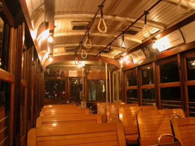
Artist Jake Berman created a map showing the extent of Dallas’s once great streetcar system. This map includes connections from the heart of the city to further out metropolises in regions like Coriscana, Waco, Denton, and Fort Worth and a network of lines traversing the city. “In fact, the new map looks like a rendering of future dreams for Dallas transit–a way to get around the inner city and plan dense development around trafficked transit corridors,” Peter Simek writes for D Magazine.
Anyone who has seen Who Framed Roger Rabbit is likely familiar with the conspiracy theories regarding the death of the streetcar. But, while car manufacturers certainly didn’t lose any sleep over the death of the streetcar, they mostly harmed it by causing the traffic that slowed it down. These slower streets, couldn’t support the then privately-owned streetcars. “By the time cities took control of the streetcars, cars had caught on and streets were crowded with traffic that slowed the lines. Service suffered. Ridership fell,” Simek writes.
“Nonetheless, looking at this revamped old map, it is difficult not to daydream about what kind of city Dallas could have been if we kept and built around the streetcar system,” Simek writes. This was Berman’s intent.
FULL STORY: Dallas Public Transit Was Better in 1919 Than It Is in 2019


DARTSpace Platform Streamlines Dallas TOD Application Process
The Dallas transit agency hopes a shorter permitting timeline will boost transit-oriented development around rail stations.

Dallas Code Reform Makes Way for Missing Middle Housing
The Dallas City Council voted to change the city’s building code to allow up to eight residential units in three-story buildings.
Texas State Bills Could Kill Transit Funding in Dallas, Austin
State lawmakers could pull funding from the state’s largest transit agency and the ambitious Project Connect, a voter-approved transit project in Austin.

Montreal Mall to Become 6,000 Housing Units
Place Versailles will be transformed into a mixed-use complex over the next 25 years.

Planetizen Federal Action Tracker
A weekly monitor of how Trump’s orders and actions are impacting planners and planning in America.

California High-Speed Rail's Plan to Right Itself
The railroad's new CEO thinks he can get the project back on track. The stars will need to align this summer.

DOJ Seeks to End USDOT Affirmative Action Program
The Disadvantaged Business Enterprise Program encouraged contracting with minority- and women-owned businesses in the transportation sector, where these groups are vastly underrepresented.

A Missouri Tenant Union’s Fight Against Millennia Housing
In Springfield, Missouri, senior and disabled tenants at one Millennia affordable housing building say they’ve gone about a year without a working elevator, but their organizing has gotten the city to threaten receivership if it's not fixed soon.

Time Running Out for Illinois Transit Bill
Chicago-area transit agencies face a daunting budget gap if lawmakers fail to agree on a funding bill by the end of the current legislative session.
Urban Design for Planners 1: Software Tools
This six-course series explores essential urban design concepts using open source software and equips planners with the tools they need to participate fully in the urban design process.
Planning for Universal Design
Learn the tools for implementing Universal Design in planning regulations.
City of Camden Redevelopment Agency
City of Astoria
Transportation Research & Education Center (TREC) at Portland State University
Municipality of Princeton (NJ)
Regional Transportation Commission of Southern Nevada