


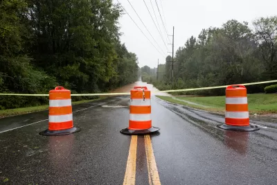
The tool will allow local planners to evaluate impacts of flooding and prioritize projects with the biggest return on investment.
The tool will allow local planners to evaluate impacts of flooding and prioritize projects with the biggest return on investment.
The North Carolina Department of Environmental Quality (DEQ) is developing a new online tool to help inform future flood planning. The “Flood Resiliency Blueprint” will compile research and data about flooding in the state to provide a framework that local officials can use to guide adaptation and mitigation efforts, says a Governing article by Adam Wagner.
In the face of more frequent, intensifying rain events, the goal is to help local governments more easily identify projects that will have measurable outcomes for their communities so they can take swift action. “Officials will be able to home in on the area where the project is proposed and see exactly how many people, homes, roads and community assets the project will protect,” Wagner writes.
The tool is designed so anyone can use it and will use two-dimensional modeling that allows planners to evaluate the impacts of flooding from rivers and heavy rain events. “To make sure we know what the projects with the best return on investment are, we are developing a standardized methodology to analyze flood risk and prioritize flood mitigation strategies across the state. We are ensuring that decision makers at all levels will be able to identify and select which strategies are most impactful where they are,” DEQ Secretary Elizabeth Biser told Governing.
The North Carolina legislature allocated a total of $20 million for the project, which includes developing and building the flood blueprint tool, as well as six river basin-specific action strategies. Another $96 million has been allocated to fund the construction of projects identified in those river-basin planning documents.
Some state legislators expressed concerns that the blueprint would be used by DEQ to tell local governments which actions they can and cannot take. Biser assured them that, apart from how the $96 million is spent, the state will not be the decision-making entity on local projects.
Beta testing for the tool is slated for mid-April and launch is expected in December.
FULL STORY: North Carolina Is Spending Millions on a Flood Blueprint


New York Needs Permeable Streets to Mitigate Future Flooding
To reduce the severity of disruptive subway flooding, the city can implement street-level solutions that absorb and redirect water before it reaches the train tunnels.

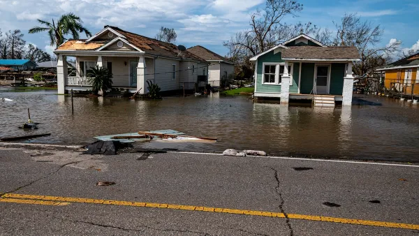
Lessons from Louisiana
We should have seen the historic flooding in the Florida Parishes region of Louisiana coming—both in preparation and in response—says a pair of recent articles.
As Trump Phases Out FEMA, Is It Time to Flee the Floodplains?
With less federal funding available for disaster relief efforts, the need to relocate at-risk communities is more urgent than ever.

Maui's Vacation Rental Debate Turns Ugly
Verbal attacks, misinformation campaigns and fistfights plague a high-stakes debate to convert thousands of vacation rentals into long-term housing.

Planetizen Federal Action Tracker
A weekly monitor of how Trump’s orders and actions are impacting planners and planning in America.

In Urban Planning, AI Prompting Could be the New Design Thinking
Creativity has long been key to great urban design. What if we see AI as our new creative partner?

King County Supportive Housing Program Offers Hope for Unhoused Residents
The county is taking a ‘Housing First’ approach that prioritizes getting people into housing, then offering wraparound supportive services.

Researchers Use AI to Get Clearer Picture of US Housing
Analysts are using artificial intelligence to supercharge their research by allowing them to comb through data faster. Though these AI tools can be error prone, they save time and housing researchers are optimistic about the future.

Making Shared Micromobility More Inclusive
Cities and shared mobility system operators can do more to include people with disabilities in planning and operations, per a new report.
Urban Design for Planners 1: Software Tools
This six-course series explores essential urban design concepts using open source software and equips planners with the tools they need to participate fully in the urban design process.
Planning for Universal Design
Learn the tools for implementing Universal Design in planning regulations.
planning NEXT
Appalachian Highlands Housing Partners
Mpact (founded as Rail~Volution)
City of Camden Redevelopment Agency
City of Astoria
City of Portland
City of Laramie