


Boise State University researchers have published a detailed study and online maps that lay out possible scenarios for urban growth in Idaho's Treasure Valley in one of the fastest-growing states in the Union.
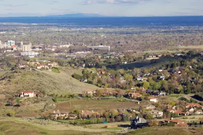
Currently home to 885,000 people the Southwest region of Idaho could grow to 1.25 million to 1.75 million by the year 2100. That rate of growth and development could lead to a loss of between 190,000 and 220,000 acres to low-density development, about four times the size of Boise. "That would cut farm loss more or less in half, the researchers predict, with just 31 percent of the region’s current agricultural land turning into urban space in the next 80 or so years. An estimated 110,000 acres would be lost," reports Maria L. La Ganga.
FULL STORY: See how half of the Treasure Valley’s farmland could disappear by 2100


Different Approaches to Fast Growth in Idaho's Treasure Valley
Three cities on the periphery of the fast-growing Treasure Valley showcase different approaches to a sudden influx of newcomers.
The Forgotten Treasure in Western Land
Will the arid West’s farms and settlements thrive for another century? Better conservation policy should take a longer view.

Housing Affordability Challenges Visit Idaho
Boise and surrounding cities are going to need new housing to meet the demand of tens of thousands of new residents in the coming years.

Maui's Vacation Rental Debate Turns Ugly
Verbal attacks, misinformation campaigns and fistfights plague a high-stakes debate to convert thousands of vacation rentals into long-term housing.

Planetizen Federal Action Tracker
A weekly monitor of how Trump’s orders and actions are impacting planners and planning in America.

In Urban Planning, AI Prompting Could be the New Design Thinking
Creativity has long been key to great urban design. What if we see AI as our new creative partner?

King County Supportive Housing Program Offers Hope for Unhoused Residents
The county is taking a ‘Housing First’ approach that prioritizes getting people into housing, then offering wraparound supportive services.

Researchers Use AI to Get Clearer Picture of US Housing
Analysts are using artificial intelligence to supercharge their research by allowing them to comb through data faster. Though these AI tools can be error prone, they save time and housing researchers are optimistic about the future.

Making Shared Micromobility More Inclusive
Cities and shared mobility system operators can do more to include people with disabilities in planning and operations, per a new report.
Urban Design for Planners 1: Software Tools
This six-course series explores essential urban design concepts using open source software and equips planners with the tools they need to participate fully in the urban design process.
Planning for Universal Design
Learn the tools for implementing Universal Design in planning regulations.
planning NEXT
Appalachian Highlands Housing Partners
Mpact (founded as Rail~Volution)
City of Camden Redevelopment Agency
City of Astoria
City of Portland
City of Laramie