


While the number of national retailers is still growing in New York City, growth is slowing and it concentrated in the restaurant and food sector of the market.
The Center for an Urban Future has released its tenth annual ranking of national retailers in New York City, finding that "the number of chain store locations across the city increased for the ninth year in a row, but fewer chains have expanded this year than in the past."
A website set up to announce and host the new report has more insight into the findings of the study. In one case, the story echoes a recent news report documenting retail closures around the city. The Center for Urban Future, however, notes that chain stores are included in the number of failed commercial storefronts:
Overall, a fifth of all national retailers in the city closed stores in the past year, and only one-in-seven retailers on our list increased their footprint—the smallest share since we began keeping track a decade ago.
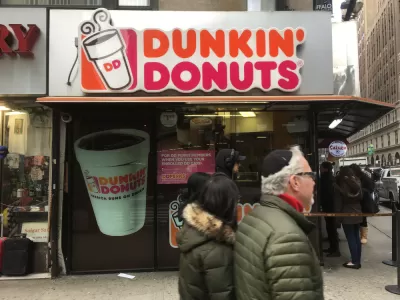
The study also ranks national retailers in terms of their presence in New York City. "For the ninth consecutive year, Dunkin’ Donuts tops our list as the largest national retailer in New York City, with a total of 612 stores, a net increase of 16 stores since 2016—and 271 since 2008," according to the post. MetroPCS is second on the list this year for the first time. The dominance of Dunkin' Donuts on the list speaks to one of the big takeaways about national retailers in New York City as reported in the study: "the growth of restaurants and food retailers is leading the charge."
FULL STORY: STATE OF THE CHAINS, 2017

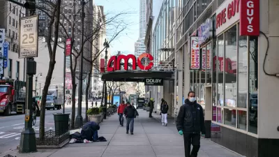
Chain Retail Slow to Recover From Pandemic in New York City
2020 was a rough year for retail chains in New York City, making even a slow year, like 2021, look like a recovery.
The State of New York City's Parks
A new report by the Center for an Urban Future signals the need for attention to the Big Apple's parks before they are beyond repair.
Library Hours in New York City Show Huge Improvements
A study by the Center for Urban Future reveals library hours in New York City to have improved a great deal in recent years—while still lagging behind state and national averages.

Maui's Vacation Rental Debate Turns Ugly
Verbal attacks, misinformation campaigns and fistfights plague a high-stakes debate to convert thousands of vacation rentals into long-term housing.

Planetizen Federal Action Tracker
A weekly monitor of how Trump’s orders and actions are impacting planners and planning in America.

Chicago’s Ghost Rails
Just beneath the surface of the modern city lie the remnants of its expansive early 20th-century streetcar system.

Bend, Oregon Zoning Reforms Prioritize Small-Scale Housing
The city altered its zoning code to allow multi-family housing and eliminated parking mandates citywide.

Amtrak Cutting Jobs, Funding to High-Speed Rail
The agency plans to cut 10 percent of its workforce and has confirmed it will not fund new high-speed rail projects.

LA Denies Basic Services to Unhoused Residents
The city has repeatedly failed to respond to requests for trash pickup at encampment sites, and eliminated a program that provided mobile showers and toilets.
Urban Design for Planners 1: Software Tools
This six-course series explores essential urban design concepts using open source software and equips planners with the tools they need to participate fully in the urban design process.
Planning for Universal Design
Learn the tools for implementing Universal Design in planning regulations.
planning NEXT
Appalachian Highlands Housing Partners
Mpact (founded as Rail~Volution)
City of Camden Redevelopment Agency
City of Astoria
City of Portland
City of Laramie