


This paper animation clip by Rob Carter shows the urban growth and development of Charlotte, North Carolina over time.
Created in 2008, this paper animation uses aerial photographs of the city to document the development of buildings and freeways in Charlotte over time.
GOOD lets us know that "[t]he entire film is screening at the Museum of Arts and Design in New York City through April 4, 2010."
FULL STORY: Intermission: Mesmerizing Stop-motion Paper Animation in Rob Carter's Metropolis


A Lone Voice for Climate: How The Wild Robot Stands Apart in Hollywood
Among this year’s Oscar-nominated films, only The Wild Robot passed the Climate Reality Check, a test measuring climate change representation in storytelling, highlighting the ongoing lack of climate awareness in mainstream Hollywood films.
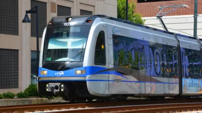
Is Charlotte Overselling Plan to Expand Transit?
Even if voters approve a new one-cent transit sales tax, will Charlotte be able to deliver on its promise of two new commuter rail lines and a new bus rapid transit line?

Charlotte’s Changing Commute Patterns
With more people working from home since the pandemic, the area is seeing shorter commute times for cars and public transit.

Maui's Vacation Rental Debate Turns Ugly
Verbal attacks, misinformation campaigns and fistfights plague a high-stakes debate to convert thousands of vacation rentals into long-term housing.

Planetizen Federal Action Tracker
A weekly monitor of how Trump’s orders and actions are impacting planners and planning in America.

In Urban Planning, AI Prompting Could be the New Design Thinking
Creativity has long been key to great urban design. What if we see AI as our new creative partner?

Portland Raises Parking Fees to Pay for Street Maintenance
The city is struggling to bridge a massive budget gap at the Bureau of Transportation, which largely depleted its reserves during the Civd-19 pandemic.

Spokane Mayor Introduces Housing Reforms Package
Mayor Lisa Brown’s proposals include deferring or waiving some development fees to encourage more affordable housing development.

Houston Mayor Kills Another Bike Lane
The mayor rejected a proposed bike lane in the Montrose district in keeping with his pledge to maintain car lanes.
Urban Design for Planners 1: Software Tools
This six-course series explores essential urban design concepts using open source software and equips planners with the tools they need to participate fully in the urban design process.
Planning for Universal Design
Learn the tools for implementing Universal Design in planning regulations.
Gallatin County Department of Planning & Community Development
Heyer Gruel & Associates PA
JM Goldson LLC
City of Camden Redevelopment Agency
City of Astoria
Transportation Research & Education Center (TREC) at Portland State University
Jefferson Parish Government
Camden Redevelopment Agency
City of Claremont