


Community input is crucial to a plan that would wrap Portland in a ring of greenery and pathways.
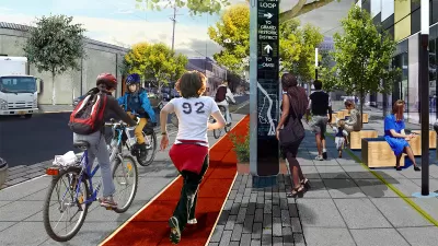
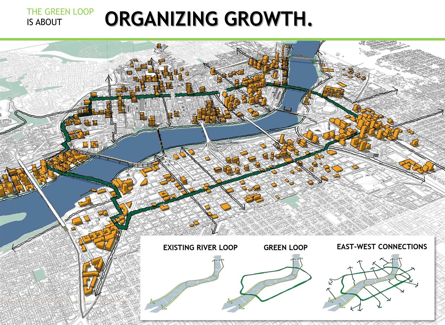
The Green Loop [pdf] is a proposed six-mile network of narrow parks that would link neighborhoods on either side of the Willamette River. Jen Kinney of Next City describes the vision thusly:
At about half the size of a typical Portland city block, the 24 narrow Park Blocks are just what they sound like: corridors of green spaces promenading through the city center. But the north and south segments are disjointed … If linked by a pedestrian and bike path, the Park Blocks would comprise about a mile of the Green Loop; the route would then continue, ultimately encircling the dense neighborhoods on both the east and west sides.
Part of Portland's pending Central City 2035 plan, the proposal is still conceptual. Recently, a pop-up exhibition during an open streets event invited the public to participate in the design process. Untitled Studio, the firm implementing the design, asked visitors to plot potential courses on a map, as well as on a 3D model of a streetscape.
The group is comprised of architects as well as journalists, and Next City details several other comprehensive, interactive community engagement strategies it is developing as part of the design process.
FULL STORY: Portlanders Asked to Imagine Linear Park Design


Study: How Urban Parks Can Support Biodiversity
Conservation and recreation can go hand in hand in urban green spaces designed to serve both humans and local wildlife.

'Greening' L.A.'s Schoolyards
Advocates for increasing green space on school campuses say giving students a more healthy outdoor environment can also reduce the urban heat island effect and improve public health in historically underserved communities.
Magic Johnson Park to Reopen in February
A much-needed park in South Los Angeles will reopen to the public after undergoing major renovations.

Maui's Vacation Rental Debate Turns Ugly
Verbal attacks, misinformation campaigns and fistfights plague a high-stakes debate to convert thousands of vacation rentals into long-term housing.

Planetizen Federal Action Tracker
A weekly monitor of how Trump’s orders and actions are impacting planners and planning in America.

In Urban Planning, AI Prompting Could be the New Design Thinking
Creativity has long been key to great urban design. What if we see AI as our new creative partner?

King County Supportive Housing Program Offers Hope for Unhoused Residents
The county is taking a ‘Housing First’ approach that prioritizes getting people into housing, then offering wraparound supportive services.

Researchers Use AI to Get Clearer Picture of US Housing
Analysts are using artificial intelligence to supercharge their research by allowing them to comb through data faster. Though these AI tools can be error prone, they save time and housing researchers are optimistic about the future.

Making Shared Micromobility More Inclusive
Cities and shared mobility system operators can do more to include people with disabilities in planning and operations, per a new report.
Urban Design for Planners 1: Software Tools
This six-course series explores essential urban design concepts using open source software and equips planners with the tools they need to participate fully in the urban design process.
Planning for Universal Design
Learn the tools for implementing Universal Design in planning regulations.
planning NEXT
Appalachian Highlands Housing Partners
Mpact (founded as Rail~Volution)
City of Camden Redevelopment Agency
City of Astoria
City of Portland
City of Laramie