


Planners across the globe have been exploring opportunities to use augmented reality to enhance the way the public engages with the city. Over the last few days Pokémon Go took off, and now people are wandering across cities to catch Pokémon.

Planners across the globe have been exploring opportunities to use augmented reality to enhance the way the public engages with the city. The recent book The City as Interface, by University of Amsterdam professor Martjin de Waal, explores the ways technology can connect people to their city. By merging digital and real space, public space can become transformed. He argues in the book that we will increasingly experience the city through our mobile devices.
Viktor Bukovszki, a recent urban design graduate, and his colleagues at Aalborg University completed a project exploring networked space. They explored the possibility of constructing customizable virtual environments that allow users to tap into the richness of public life through their smartphone. The team looked at Aalborg in Denmark and examined ways recent immigrants could better engage in the city's public space. The team proposed an app that would allow participants to go through the city on quests where they would learn about Danish language and culture and also meet and interact with new people. Little did Bukovszki know but a new game, Pokémon Go, was about to be released that makes many of his team's ideas a reality.
Over the last few days Pokémon Go took off, and now people are wandering across cities to catch Pokémon. As soon as I arrived at work on Monday people began asking if I was playing. As an avid techie, I asked my intern, who I had seen wandering the building catching Pokémon, to teach me the basics. I'm finding walks to meetings much more engaging, noticing plaques and points of interest that I had previously just walked right past.
On my walk from the office to lunch I encountered two Pokéstops (aka historic markers) and captured a Bulbasaur.
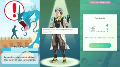
The Pokémon Go augmented reality app uses the mobile devices GPS and camera. Users simply walk around and wait for Pokémon to appear on the screen. The user catches the Pokémon and throws Poké Balls at them. Users can stop at Pokéstops to collect items. The Pokéstops are points of interest in the real world, ranging from historical landmarks, public art, statues, parks, and businesses, where users can get supplies. For example, there are three Pokéstops at the park in my neighborhood.
The game is highly engaging and has people out walking all over their community. People are walking individually, with their family and friends, or through organized meetups to hunt for Pokémon.
Laura Solitare, a planning professor at Texas Southern University, notes that it is an addictive game "making us walk and want to go out adventuring." Solitare notes it is easy to find people playing the game from the special way people hold their phones and she has found it fun to meet other "trainers." She has found people asking her "did you find any Pokémon around here"—in museums, parks and shopping centers.

Greg Griffin, a transportation researcher at the Texas A&M Transportation Institute, notes that the Pokémon’s habitat is primarily in public space. He went on a walk to the park with his sons where they saw a friend, passed a duck and racked up Pokémon Go experience points. Chris Germain, a planner with the Ohio EPA, has been using the game while on vacation. While on a bike ride he found himself going out of the way to catch Pokémon.
Pokéstops are annotated providing information on each location, allowing people to learn more about the place.
Local businesses and other locations can create a lure module, which creates a Pokéstop. While at my neighborhood Chipotle, my son found a gem in the parking lot. The Chipotle employees asked if he was playing Pokémon Go, they noted they have seen a number of people coming into the restaurant since it became designated as a gym in the game, allowing players to engage in training battles.
The game works best in urban and denser suburban areas where there are more common points of interest. In rural areas there are rarely Pokéstops. There is a distinct and noticeable difference in the frequency of game related activities as one moves to less dense locations.

While the game has created a ton of interest, with many active players, it has also created community concern. This discussion on my community's Facebook discussion page highlights some of the safety concerns, for example trespassing on private property. Some people get so caught up in the game that they don’t think to watch where they are going, walking into traffic.
The game at less than a week old already has well over 7.5 million downloads. So far users are averaging 43 minutes per day in the game. Looks like people are certainly getting in more exercise walking! The will soon be released for play in Europe and Asia.
Are you using Pokémon Go or seen players in your community? Share what you are observing in the comments section below.

Latest Plans for Atlanta's 'The Gulch' Megaproject Focuses on the Public Realm
The latest round of plans and designs released for The Gulch by developer Centennial Yards Company plots increased walkability and urban design choices that respond to the existing built environment.

Friday Fun: CityLab Picks the Best Games of 2020
In the year of stay-at-home orders, people turned to old and new games to stay sane and stay connected.

Town Building Game Offers Moments of Pandemic Zen
Townscraper, a new "casual town building" game earned good reviews among early adopters this summer.

Maui's Vacation Rental Debate Turns Ugly
Verbal attacks, misinformation campaigns and fistfights plague a high-stakes debate to convert thousands of vacation rentals into long-term housing.

Planetizen Federal Action Tracker
A weekly monitor of how Trump’s orders and actions are impacting planners and planning in America.

Chicago’s Ghost Rails
Just beneath the surface of the modern city lie the remnants of its expansive early 20th-century streetcar system.

Bend, Oregon Zoning Reforms Prioritize Small-Scale Housing
The city altered its zoning code to allow multi-family housing and eliminated parking mandates citywide.

Amtrak Cutting Jobs, Funding to High-Speed Rail
The agency plans to cut 10 percent of its workforce and has confirmed it will not fund new high-speed rail projects.

LA Denies Basic Services to Unhoused Residents
The city has repeatedly failed to respond to requests for trash pickup at encampment sites, and eliminated a program that provided mobile showers and toilets.
Urban Design for Planners 1: Software Tools
This six-course series explores essential urban design concepts using open source software and equips planners with the tools they need to participate fully in the urban design process.
Planning for Universal Design
Learn the tools for implementing Universal Design in planning regulations.
planning NEXT
Appalachian Highlands Housing Partners
Mpact (founded as Rail~Volution)
City of Camden Redevelopment Agency
City of Astoria
City of Portland
City of Laramie