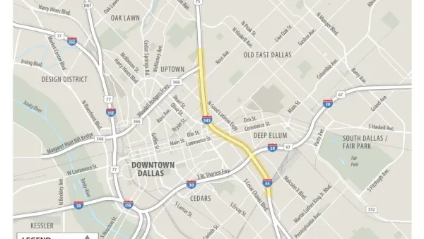
The Texas Department of Transportation (TxDOT) has envisioned a future for Downtown Dallas that includes more downtown and fewer freeways.



Brandon Formby reports on a "surprising yet powerful voice" adding to the "joining the chorus calling for a sea change in downtown Dallas’ car-centric infrastructure building":
The Texas Department of Transportation released a report Friday [June 10] that lays out several scenarios for minimizing congestion on the noose of aging highways that chokes off urban neighborhoods from the Central Business District. The study, called CityMAP, offers a stark departure from the agency’s standby approach of adding more highway lanes or re-engineering traffic chokepoints.
Included among the options explored in the CityMAP (short for the Dallas City Center Master Assessment Process) report: tearing down Interstate 345 and moving a stretch of Interstate 30 out of downtown to a new route farther south in Fair Park.
According to Formby, "CityMAP doesn’t suggest one construction option over another. Instead, the report is meant to arm urbanites, city officials and regional planners with data and estimated effects so a holistic plan can be pieced together for the urban core’s transportation network."
Read the full story: New TxDOT downtown Dallas plan includes a scenario with a freeway's demise

Dallas City Hall Begins to Ponder a New Future for the I-345
A proposal once too controversial to consider is gaining traction at several layers of government.
Columnist to Dallas: Tear Down That Freeway
Freeways have been removed before, but if the Texas Department of Transportation decides to tear down the I-345 freeway in Dallas, it would reflect a massive sea change in urban transportation planning.
The Right Planning Consultant Could Make All of the Difference
Between DART service optimization and deciding the fate of I-345, Dallas has big of decisions to make. The right consultant, who understands accurate framing of planning issues, could help choose a route that best serves Dallasites.

Planetizen Federal Action Tracker
A weekly monitor of how Trump’s orders and actions are impacting planners and planning in America.

California plans to bury El Niño’s downpour
If the state plays its cards right, it may be able to store a billion acre-feet of El Niño’s water in aquifers.

Chicago breaks ground on $3 billion megadevelopment
The new neighborhood, titled Foundry Park, will one day host 3,700 residences.

California High-Speed Rail Authority CEO resigns after $600,000 scandal
Under Ian Choudri, the authority used taxpayer dollars to fund first class flights and trips to nightclubs.

Want to study the Missouri River? Soon, you may need unanimous approval from 10 states
Legislation would require 10 governors’ permission to study or build projects moving water outside the basin.

Desperate measures: Advocates weigh draining Lake Powell to fill Colorado River
Draining the reservoir could reduce evaporation losses by a couple hundred thousand acre-feet.

FREE Course: Walkable City 1: Why Walkability?
After describing his path towards focusing on walkability as the essence of good planning, Jeff Speck marches through his five principal reasons for making more walkable places.
Reinventing Malls: Planning Alchemy—Turning Gray Fields Into Gold
The course focuses on the opportunities and imperatives that shape reinvention of mall sites.

City of Rosemead
Rutgers University, Edward J. Bloustein School of Planning and Public Policy
One Hundred Miles
Hunter College, City University of New York (CUNY)
The Architects Foundation
University of Cincinnati Online
City of Cambridge
Montrose County
The Pocatello Development Authority