


A NASA study finds that no irrigated vegetation covers more surface in the United States than the collection of lawns that are so important to the American identity.

"Americans’ lawns now cover an area three times larger than any irrigated crop in the U.S.," according to a post by Rob Wile.
"According to a new study [pdf] from NASA scientists in collaboration with researchers in the Mountain West, there is now an estimated total of 163,812 square kilometers, or more than 63,000 square miles, of lawn in America — about the size of Texas."
The study focused on the environmental of the country's lawns, finding good news and bad news. For good news, lawns remove carbon dioxide from the atmosphere. For bad news, many lawns uses up to 900 liters of water a day.
FULL STORY: The American lawn is now the largest single ‘crop’ in the U.S.


Let the Lawns Go
According to one Dallas suburbanite, the American lawn is a "decadent and unsustainable totem[s] of middle-class prosperity."

Arizona Native Community Launches First Solar-Over-Canal Project
Covering an irrigation canal with solar panels doubles its utility, producing renewable energy while protecting canal infrastructure and reducing water evaporation.
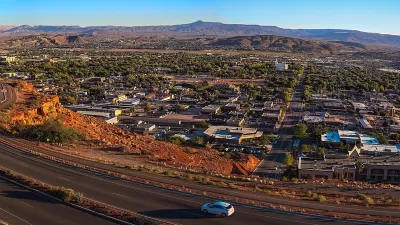
Southwest Utah Lawn ‘Buyback’ Program Pays Off
Washington County has dramatically reduced per-capita water use, but the region’s explosive growth means increased demand for water.

Maui's Vacation Rental Debate Turns Ugly
Verbal attacks, misinformation campaigns and fistfights plague a high-stakes debate to convert thousands of vacation rentals into long-term housing.

Planetizen Federal Action Tracker
A weekly monitor of how Trump’s orders and actions are impacting planners and planning in America.

In Urban Planning, AI Prompting Could be the New Design Thinking
Creativity has long been key to great urban design. What if we see AI as our new creative partner?

King County Supportive Housing Program Offers Hope for Unhoused Residents
The county is taking a ‘Housing First’ approach that prioritizes getting people into housing, then offering wraparound supportive services.

Researchers Use AI to Get Clearer Picture of US Housing
Analysts are using artificial intelligence to supercharge their research by allowing them to comb through data faster. Though these AI tools can be error prone, they save time and housing researchers are optimistic about the future.

Making Shared Micromobility More Inclusive
Cities and shared mobility system operators can do more to include people with disabilities in planning and operations, per a new report.
Urban Design for Planners 1: Software Tools
This six-course series explores essential urban design concepts using open source software and equips planners with the tools they need to participate fully in the urban design process.
Planning for Universal Design
Learn the tools for implementing Universal Design in planning regulations.
planning NEXT
Appalachian Highlands Housing Partners
Mpact (founded as Rail~Volution)
City of Camden Redevelopment Agency
City of Astoria
City of Portland
City of Laramie