


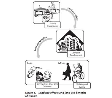
New research quantifies public transit impacts on urban development patterns, and resulting benefits. Current transit services reduces U.S. urban land consumption by 27 percent, which reduces VMT, fuel consumption and pollution emissions 8 percent.
A new report, "Quantifying Transit’s Impact on GHG Emissions and Energy Use—The Land Use Component," by the Transit Cooperative Research Program, uses sophisticated statistical analysis to examine interrelationships between transit and land use patterns to understand their impacts on urban development patterns, per capita vehicle travel and pollution emissions. It includes a calculator tool that planners can use to predict these impacts in a particular situation.
This research found:
• Effect on population densities. U.S. urban population densities would be 27 percent lower without transit systems to support compact development, causing these cities to consume 37 percent more land area in order to house their current populations.
• Effect on VMT, fuel use, and transportation GHG. By providing more walking and biking opportunities and making some journeys by car shorter, the land use effect of transit produces land use benefits: an aggregate 8 percent decrease in VMT, transportation fuel use, and transportation GHG emissions in U.S. cities.
• Effect of transit trips replacing automobile trips. By transporting people on buses and trains who would otherwise travel by automobile, transit systems also produce a complementary ridership effect. In aggregate across U.S. cities, transit ridership reduces VMT, transportation fuel use, and transportation GHG emissions by 2 percent. This is a substantial change given that only 4 percent of passenger trips are currently made by transit in U.S. metropolitan areas.
• Land use benefit of transit. The land use benefit of transit varies across urban areas, ranging from a 1 percent to 21 percent reduction in VMT, transportation fuel use, and transportation GHG emissions compared to a hypothetical scenario without transit. Urban areas with higher route densities of transit, service frequencies of transit, and availability of light rail have higher land use benefits. Not surprisingly, higher land use benefits of transit are generally found in more densely developed areas.
• The land use effect of transit in a given region typically reduces GHG emissions more than the ridership effect. The average ratio of land use benefits to ridership benefits across all U.S. cities is 4:1, but the ratio varies substantially across different urban areas.
• Adding a rail station to a neighborhood that did not previously have rail access is associated with a 9 percent increase in activity density (combined population and employment density) within a 1-mile radius of the rail station. The corresponding land use benefit is a 2 percent reduction in VMT (for households within the 1-mile radius), transportation fuel use, and transportation GHG emissions.
• Improving employment accessibility, by clustering new jobs around transit nodes or improving the bus and rail network in individual neighborhoods, can also have potent land use effects.
• Analysis of Portland’s Westside light-rail extension found that the land use effect increased densities by 24 percent in the corridor area between 1994 and 2011. These changes correspond to a 6 percent household VMT reduction due to the land use effect and an additional 8 percent VMT reduction due to the ridership effect.
This is a major contribution toward planners understanding of how transportation planning decisions affect land use development patterns, and how this leverages changes in travel activity, energy consumption and pollution emissions.
FULL STORY: Quantifying Transit’s Impact on GHG Emissions and Energy Use—The Land Use Component

Why Should We Subsidize Public Transportation?
Many public transit agencies face financial stress due to rising costs, declining fare revenue, and declining subsidies. Transit advocates must provide a strong business case for increasing public transit funding.
Can We Resist Displacement From Transit-Oriented Development?
Transit stations increase nearby jobs and populations, but they could also contribute to displacement. What can we do differently?

Parking Reform Can Boost Homebuilding 40 to 70 Percent
More evidence that parking flexibility is key to housing abundance.

Maui's Vacation Rental Debate Turns Ugly
Verbal attacks, misinformation campaigns and fistfights plague a high-stakes debate to convert thousands of vacation rentals into long-term housing.

Planetizen Federal Action Tracker
A weekly monitor of how Trump’s orders and actions are impacting planners and planning in America.

Chicago’s Ghost Rails
Just beneath the surface of the modern city lie the remnants of its expansive early 20th-century streetcar system.

Bend, Oregon Zoning Reforms Prioritize Small-Scale Housing
The city altered its zoning code to allow multi-family housing and eliminated parking mandates citywide.

Amtrak Cutting Jobs, Funding to High-Speed Rail
The agency plans to cut 10 percent of its workforce and has confirmed it will not fund new high-speed rail projects.

LA Denies Basic Services to Unhoused Residents
The city has repeatedly failed to respond to requests for trash pickup at encampment sites, and eliminated a program that provided mobile showers and toilets.
Urban Design for Planners 1: Software Tools
This six-course series explores essential urban design concepts using open source software and equips planners with the tools they need to participate fully in the urban design process.
Planning for Universal Design
Learn the tools for implementing Universal Design in planning regulations.
planning NEXT
Appalachian Highlands Housing Partners
Mpact (founded as Rail~Volution)
City of Camden Redevelopment Agency
City of Astoria
City of Portland
City of Laramie