


Buried beneath the enthusiasm that’s accompanied the unveiling of Peter Zumthor’s design for the Los Angeles County Museum of Art is one important criteria by which the project should be evaluated: how does it contribute to the urban environment?

Buried beneath the breathless enthusiasm that’s accompanied the unveiling of architect Peter Zumthor’s design for a remade Los Angeles County Museum of Art (LACMA) is one important criteria by which the $650 million endeavor should be evaluated: how does it contribute to the urban environment?
While the challenges of fundraising and questions over whether to preserve the museum’s hodgepodge of current buildings have received the most attention, the mega-building’s impact on the surrounding streets has received little. In a city looking to break free from its car-centric past by facilitating alternative means of transportation and pedestrian-oriented environments, this is dispiriting. This is, after all, a public building sitting on public land. It’s imperative that the building serves the city, and not just the whims of an ambitious director and his design prophet.
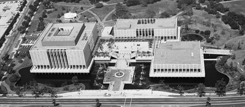
From Welton Becket and Associates’ Music Center (1964) to Richard Meier’s Getty Center (1997), Los Angeles has a history of designing its cultural campuses as islands in the city. In fact, when LACMA was completed in 1965, William Pereira’s three original galleries were separated from Wilshire Boulevard by a moat.
L.A. also has a history of neglecting its public spaces. But with new parks (large and small), new trails, tactical interventions, community events, and an expanded transit system, that’s beginning to change. The City, or County in this case, should be building pedestrian-friendly environments, especially adjacent to the location of a future station along the “subway to the sea”.
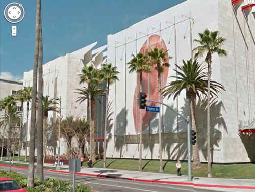
So, how does the museum think of its relationship to the street and the larger city? In the last decade, LACMA expanded to the west and north with new buildings designed by Renzo Piano. Unfortunately, the results of this expansion aren't exactly encouraging. Though Chris Burden's Urban Light piece provides a fine forecourt, the Broad Contemporary Art Museum is a 60,000 square foot behemoth whose hulking south façade turns its back to Wilshire Boulevard, providing a blank backdrop for auto-oriented billboards.
Rethinking LACMA’s campus provides an opportunity for one of Los Angeles’s premier public institutions to re-engage with a changing city where walkability and bikeability are becoming paramount to drivability. Located on a prominent site along the city’s densest thoroughfare, and within close proximity to transit, LACMA has a responsibility to deliver people-oriented architecture, rather than a design oriented to the view from the sky, or what Danish designer Jan Gehl calls “bird shit” architecture.
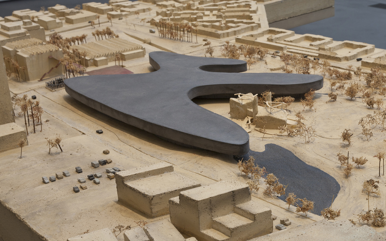
Who cares whether the building looks like a lake, flower, or inkblot from 500 feet above? How does it look to a family walking along Wilshire Boulevard?
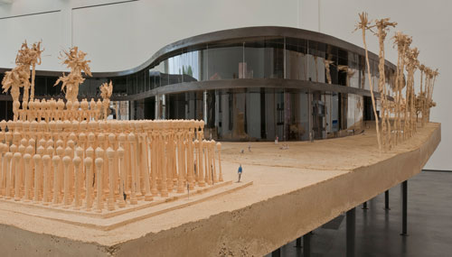
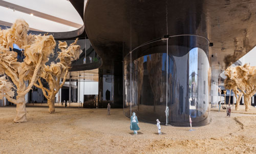
Could Zumthor’s design be an improvement over the current campus? Perhaps. As Christopher Hawthorne indicates, the design is preliminary. Elements like cladding, lighting, and landscaping have yet to be articulated. A more porous relationship to the street and increased visibility for the artworks suggested by the current design could create a more pleasant pedestrian experience. Though the oppressive environment suggested by the relentlessly black model Zumthor’s team has built looks more appropriately scaled for the Columbian mammoth recovered from the neighboring La Brea Tar Pits than a human being.
Los Angeles doesn’t need more exorbitant trophy objects, it needs great places. And our discussion of this proposal should reflect that.

Design Crit: LACMA's Proposal to Bridge Wilshire Boulevard Misreads Los Angeles
The proposed expansion of the Los Angeles County Museum of Art recently got a major revision—now instead of cantilevering over the La Brea Tar Pits, the building would bridge Wilshire Boulevard.
L.A. Museum Redesign Aims to Redefine How the Public Engages Art
Soon to be unveiled plans for a $650 million redesign of the Los Angeles County Museum of Art by Pritzker Prize winning architect Peter Zumthor "would rank as one of the most significant works of architecture to rise in Los Angeles," if completed.

Trying to Remake L.A. as a More Walkable City
A legacy of discriminatory planning exacerbated the low-density sprawl that's been so hard for Los Angeles to roll back.

Planetizen Federal Action Tracker
A weekly monitor of how Trump’s orders and actions are impacting planners and planning in America.

Chicago’s Ghost Rails
Just beneath the surface of the modern city lie the remnants of its expansive early 20th-century streetcar system.

Amtrak Cutting Jobs, Funding to High-Speed Rail
The agency plans to cut 10 percent of its workforce and has confirmed it will not fund new high-speed rail projects.

Ohio Forces Data Centers to Prepay for Power
Utilities are calling on states to hold data center operators responsible for new energy demands to prevent leaving consumers on the hook for their bills.

MARTA CEO Steps Down Amid Citizenship Concerns
MARTA’s board announced Thursday that its chief, who is from Canada, is resigning due to questions about his immigration status.

Silicon Valley ‘Bike Superhighway’ Awarded $14M State Grant
A Caltrans grant brings the 10-mile Central Bikeway project connecting Santa Clara and East San Jose closer to fruition.
Urban Design for Planners 1: Software Tools
This six-course series explores essential urban design concepts using open source software and equips planners with the tools they need to participate fully in the urban design process.
Planning for Universal Design
Learn the tools for implementing Universal Design in planning regulations.
Caltrans
City of Fort Worth
Mpact (founded as Rail~Volution)
City of Camden Redevelopment Agency
City of Astoria
City of Portland
City of Laramie