With the opening last weekend of the city's first pilot parklet in the neighborhood of Eagle Rock, Los Angeles is hoping to join the ranks of cities hopping on the low-cost trend in public space creation.


While the Sunset Triangle Plaza may be the first co-called "parklet" to have been built in the city (though it converted more than just parking spaces), the park just opened last weekend on the site of a former illegal parking space in Eagle Rock is the first of the city's official pilot parklet program to be completed. The city has a long way to go to catch up to the likes of San Francisco, and their 40 such spaces.
Sam Lubell describes the project, which is the result of a truly collaborative effort:
"The $30,000 space is modest in scope: it features stained wood plank flooring, curving built-in wood furniture, and mosaic tile furniture and siding. But as the city's first parklet it represents a major milestone. The parklets initiative involves intensive coordination between several city departments, including the Department of Transportation (DOT), the Department of Planning, the Bureau of Engineering, the Bureau of Street Services, the mayor’s office, and various city council offices. The parklet was sponsored by LA councilman Jose Huizar, planned and coordinated by non-profit Living Streets LA, and built by the LA Conservation Corps (which gives at-risk young adults work experience through conservation and service projects)."
"This first round of [four] parklets took more than two years to realize, not because of the complexity of their designs, but because of the significant community outreach and input involved and the development of an entirely new approval process, which is now coming into shape. Future parklets should take less time to complete, said Tricia Roberts, deputy planning director for Los Angeles councilman Jose Huizar’s [sic]."
Read the full story: Power to the Parklet
Pilot Parklet Program Finds Fans in L.A., May Expand
Before its launch, a skeptic in car-crazy L.A. might have wondered whether a pilot program to transform parking spaces into pocket parks would have much success. But, to the delight of backers, the parklets have been a hit and may expand citywide.

A New Twist for Bus Rapid Transit Controversy in Northeast Los Angeles
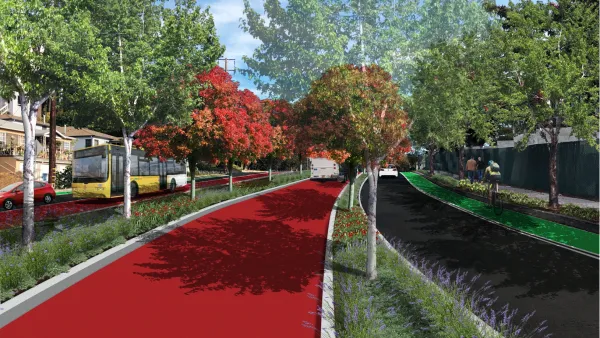
A recently appointed councilmember threw a wrench into hard fought local negotiations over a planned bus rapid transit that passes through the Los Angeles neighborhood of Eagle Rock.
Controversial BRT Plans Revised in Los Angeles
The proposed changes to plans for a bus rapid transit route on Colorado Boulevard are an attempt to compromise between competing community concerns.

Planetizen Federal Action Tracker
A weekly monitor of how Trump’s orders and actions are impacting planners and planning in America.

Eastern Nebraska is running out of electricity
Data centers and electrification are straining eastern Nebraska’s grid, throttling economic development.

Study reveals best places in the U.S. for cycling, walking
New research from Streetlight Data examines bicycle and pedestrian miles per capita in the 100 largest U.S. cities by population.

DSA members accuse Mamdani of 'abandoning values' over housing redevelopment
New York City's mayor plans to replace about 2,000 units of public housing with private, mixed-income housing.

All sides of BRT debate unhappy with CDOT’s most recent move
The Colorado Department of Transportation is no longer considering center-running bus lanes for Colorado Boulevard.

Massachusetts bogs generate both power, and cranberries
Putting solar panels above farmland is one way Massachusetts is advancing toward its goal of net-zero carbon emissions by 2050.

FREE Course: Walkable City 1: Why Walkability?
After describing his path towards focusing on walkability as the essence of good planning, Jeff Speck marches through his five principal reasons for making more walkable places.
Reinventing Malls: Planning Alchemy—Turning Gray Fields Into Gold
The course focuses on the opportunities and imperatives that shape reinvention of mall sites.

City of Rosemead
Rutgers University, Edward J. Bloustein School of Planning and Public Policy
One Hundred Miles
University of Michigan School for Environment and Sustainability (SEAS)
Hunter College, City University of New York (CUNY)
The Architects Foundation
City of Cambridge
The Pocatello Development Authority
The Urban Renewal Agency of the City of Pocatello