


Like the U.S. in the mid-20th Century, much of the growth in Abu Dhabi over the last 35 years has catered primarily to the automobile. But new plans are re-wiring the city to make Abu Dhabi's streets more hospitable to pedestrians.
 Abu Dhabi is a city of almost 900,000 people. It has grown remarkably since 1960, when it was a dusty village of 25,000 whose economy was based on camel herding, pearl diving, fishing and date farming. That was about the time it was discovered that Abu Dhabi –now one of the seven emirates comprising the nation of the United Arab Emirates – was sitting on one-tenth of the world's oil reserves.
With most of its growth occurring after 1975, Abu Dhabi grew during the height of the automobile era. With endless supplies of cheap oil, it was logical that planners built a city based almost solely upon car travel, just as the U.S. did in the 1950s and 1960s when it was the world's leading oil producer. Transit was deemed irrelevant, and the city grew around a backbone of wide boulevards laid out in a grid of super blocks. The downtown is dominated by 20 or more-story buildings fronting these congested boulevards.
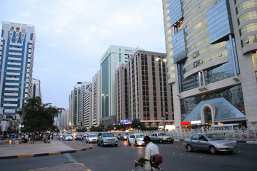
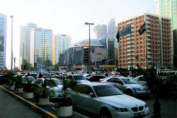
Most of the streets are clogged by illegal parking that is tolerated by municipal authorities. The net result is the same as it has been for every other automobile-oriented city in the world: cars and more cars, backed up 18 hours a day.
With the downtown core developed to capacity, smaller satellite business districts developed wherever there was space.
A few years ago, Abu Dhabi wisely recognized it would be a mistake to continue basing its growth on the automobile and cheap energy. The problems of traffic congestion, resource consumption and environmental sustainability needed to be addressed. In September 2007, the government released Plan Abu Dhabi 2030, which calls for new national performance measures that respect natural resources, the fragile environment, air quality and livability. A nation that has enough oil to last a lifetime has decided to " cautiously use existing wealth, to actively explore renewable energy production, to reduce the consumption of non renewable resources."
The release of this green plan was logically followed by a new set of guidelines on street design, the Urban Street Design Manual (SDM). I played a part in helping Abu Dhabi's Department of Transport, Urban Planning Council, and a consultant team led by Otak International and Nelson Nygaard in shaping the new streets plan.
Abu Dhabi's SDM pays homage to A Policy on Geometric Design of Highways and Streets by the American Association of State Highway Transportation Officials(the AASHTO "Green Book") – America's nearly universally accepted highway design guidebook. While thanking AASHTO for serving as the foundation for the design of the current transportation network in Abu Dhabi, the SDM team concluded that the Green Book does not adequately serve as a guide for " urban streets where modes of transportation other than the automobile are present."
Abu Dhabi's new plan for street design is based upon the following community-based principles:
- Good street design starts with pedestrians. The world's great cities are delightful and safe for walking, resulting not only in lower rates of driving but also improved public health.
- Good street design supports Abu Dhabi's environmental goals: reducing CO2 emissions, minimizing the urban heat island effect and reducinig water consumption.
- Street connectivity enhances road capacity and allows smooth traffic flow. Congestion worsens when most vehicle traffic is funneled onto arterial streets.
- Street design follows from a sense of place. Streets are not just for movement of vehicles, but for enhancing the communities they pass through. This means paying attention to the enjoyment of residents and the success of businesses
Abu Dhabi's Street Design Manual also established policies on several innovative concepts that transportation advocates have long pushed for in the U.S, such as performance measures for pedestrians, transit and bicyclists, not just cars. It recognizes the value of "Streets as Places" and adapts the PPS Street Audit, a survey which transportation stakeholders can use to evaluate their streets, as well as introducing a toolbox of initiatives to promote street connectivity.
Wow!
A city with enough oil wealth to accomplish whatever it pleases has decided to ease back on auto-dominated development and create a sustainable transportation system for the 21st Century. A city that continues to grow by leaps and bounds has decided to reinvent itself based on placemaking. Why can't we do the same in the U.S.?
Of course, there are some unique circumstances in Abu Dhabi that do not apply in the United States:
- Abu Dhabi has a different political structure and does not face much public resistance to get things done. I found that the Abu Dhabi government is open to ideas and input from outside, but it is true that he level of democratic involvement in decision making is much lower than in Western nations.
- Abu Dhabi is in a much sounder financial position based on the nationalization of their oil reserves. This wealth will certainly make a difference when it comes to rightsizing and adding traffic calming to existing roads, as well as creating the new transit system that is to become the backbone of Abu Dhabi.
- Abu Dhabi has only recently become a major city so its bureaucracies have not had the time to develop an entrenched culture.
While the U.S. clearly faces obstacles not found in Abu Dhabi, there is no doubt in my mind that we can turn the corner toward sustainable and sensible transportation here. Over the past few years, a number of cities and regions have developed progressive design guidelines that link street features and dimensions to the context of local communities. These documents move us toward street designs that encourage appropriate traffic speeds and safe travel for a variety of transportation modes.
Gary Toth has worked over 36 years in transportation and environmental planning, most recently being involved with the integration of both into land use and community planning. He also has been a leader in Context Sensitive Solutions since the beginning of the program in the 1990s. Now retired after 34 years at the New Jersey Department of Transportation (NJDOT), Gary is Senior Director, Transportation Initiatives with the Project for Public Spaces.

Masdar Highlights Policy Shift Away From Autopia
Robert Wright describes the policy shift already underway in planning for cities of the future. He reports that "as energy becomes more expensive, cities will have to be much more compact, easier to navigate by bike and on foot."
Debating Freeway Expansion Projects Around Louisville
Several large freeway expansion projects are in various stages of planning and development in the Louisville region of Kentucky. Critics say the projects reflect an obsolete approach to planning and will hurt the state and the city.

Largest Desalinated Water Reserve Ever Unveiled in Abu Dhabi
The UAE has created a storage facility under the desert that can provide up to 100 million liters per day in the event of an emergency.

Maui's Vacation Rental Debate Turns Ugly
Verbal attacks, misinformation campaigns and fistfights plague a high-stakes debate to convert thousands of vacation rentals into long-term housing.

Planetizen Federal Action Tracker
A weekly monitor of how Trump’s orders and actions are impacting planners and planning in America.

In Urban Planning, AI Prompting Could be the New Design Thinking
Creativity has long been key to great urban design. What if we see AI as our new creative partner?

Cal Fire Chatbot Fails to Answer Basic Questions
An AI chatbot designed to provide information about wildfires can’t answer questions about evacuation orders, among other problems.

What Happens if Trump Kills Section 8?
The Trump admin aims to slash federal rental aid by nearly half and shift distribution to states. Experts warn this could spike homelessness and destabilize communities nationwide.

Sean Duffy Targets Rainbow Crosswalks in Road Safety Efforts
Despite evidence that colorful crosswalks actually improve intersection safety — and the lack of almost any crosswalks at all on the nation’s most dangerous arterial roads — U.S. Transportation Secretary Duffy is calling on states to remove them.
Urban Design for Planners 1: Software Tools
This six-course series explores essential urban design concepts using open source software and equips planners with the tools they need to participate fully in the urban design process.
Planning for Universal Design
Learn the tools for implementing Universal Design in planning regulations.
Appalachian Highlands Housing Partners
Gallatin County Department of Planning & Community Development
Heyer Gruel & Associates PA
Mpact (founded as Rail~Volution)
City of Camden Redevelopment Agency
City of Astoria
City of Portland
City of Laramie