


Environmental activists and other organizations are using Google Earth to document environmental damage and to promote their various causes.
"Following media coverage, environmental groups started contacting [Rebecca Moore at Google] to learn how they could use Google Earth for their own campaigns. At Google, Moore started setting up in-house programs to help non-profits. As demand continued to grow, the company began to realize there was an enormous opportunity to help organizations illustrate and advocate for their causes. In 2007, the company set up a new unit, Google Earth Outreach, to do just that - and tapped Moore to lead it.
The U.S. Holocaust Museum in Washington has used Google Earth to disseminate information about what some are calling genocide in Darfur. Google Earth users can fly in on villages that have been destroyed and learn more about how many people have been displaced. An east coast non-profit has successfully used the tool to raise awareness about the environmental impacts of mountaintop removal coal mining in Appalachia and to generate support for a clean water bill in Congress. UNESCO has used it to call attention to endangered world heritage sites. And over the summer, Moore and a Google Earth Outreach team flew to South America to teach an indigenous Amazonian tribe how to use the tool's satellite images to spot illegal logging and mining activity on their land.
The tool can be used to envision potential solutions as well as to identify problems, Moore says. The Appalachia group, for example, used Google Earth to envision a future where mountaintops were covered with wind turbines, and to show how a renewable energy source like wind could produce far more energy over time than the finite amount of underlying coal."
FULL STORY: Life on Google Earth


Visualizing Worst-Case Scenario Sea Level Rise on the Texas Coast
Much of the state political leadership in Texas has been slow to accept the existence of climate change, much less the role of the state's economy, land use, and infrastructure planning in exacerbating the crisis. Maybe this will help wake them up?
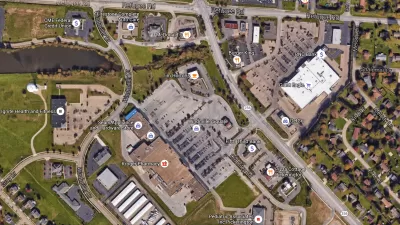
Retail Parking: A View from Google Earth
Google Earth can be a useful tool for understanding how parking is being used in your community and to identify where over- or under-utilization occurs.
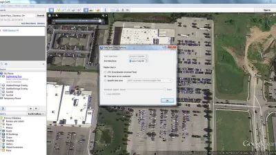
Using Google Earth to Understand Parking Utilization
As planners we use maps on a daily basis. This article shares how to find the date and time that a Google Earth image was taken, which can be helpful in undertaking site analysis and understanding parking utilization.

Maui's Vacation Rental Debate Turns Ugly
Verbal attacks, misinformation campaigns and fistfights plague a high-stakes debate to convert thousands of vacation rentals into long-term housing.

Planetizen Federal Action Tracker
A weekly monitor of how Trump’s orders and actions are impacting planners and planning in America.

Chicago’s Ghost Rails
Just beneath the surface of the modern city lie the remnants of its expansive early 20th-century streetcar system.

Bend, Oregon Zoning Reforms Prioritize Small-Scale Housing
The city altered its zoning code to allow multi-family housing and eliminated parking mandates citywide.

Amtrak Cutting Jobs, Funding to High-Speed Rail
The agency plans to cut 10 percent of its workforce and has confirmed it will not fund new high-speed rail projects.

LA Denies Basic Services to Unhoused Residents
The city has repeatedly failed to respond to requests for trash pickup at encampment sites, and eliminated a program that provided mobile showers and toilets.
Urban Design for Planners 1: Software Tools
This six-course series explores essential urban design concepts using open source software and equips planners with the tools they need to participate fully in the urban design process.
Planning for Universal Design
Learn the tools for implementing Universal Design in planning regulations.
planning NEXT
Appalachian Highlands Housing Partners
Mpact (founded as Rail~Volution)
City of Camden Redevelopment Agency
City of Astoria
City of Portland
City of Laramie