


Contrary to conventional wisdom, cities in the East are sprawling faster than their West coast counterparts.
 Most metropolitan areas are consuming land for urbanization much more rapidly than they are adding population. In that sense, most U.S. metro areas are "sprawling" more rapidly today than they have in the past. However, in many ways, the conventional wisdom about metropolitan densities and sprawl in the United States is inaccurate.
We define sprawl in terms of consumption of land resources only. In research for the Brookings Center on Urban and Metropolitan Policy, we calculated the density of every metropolitan area in the United States between 1982 and 1997. Density was defined as the population (estimated from the decennial census) divided by the urbanized land (derived from the National Resources Inventory's national survey of land use, conducted every five years). Our research was based on an actual measurement of urbanized land, rather than the Census Bureau's definition of "urbanized area," which does not measure land use.
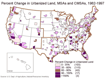 We found that many of the densest metropolitan areas in the United States are located in the West -specifically, in California, Arizona, and Nevada. The older metropolitan areas of the Northeast and Midwest also have historically high density at their core, but their recent development has sprawled dramatically, reducing their overall population density by large amounts in only 15 years.
According to conventional wisdom, Western cities are sprawling because they are auto-oriented and older Northeastern and Midwestern cities are dense because they are dense in the aging core. In some sense, the conventional wisdom is correct. Western cities are auto oriented - that is, they do not have extremely dense old cores and they are built at densities that make it difficult to provide public transit alternatives. And in the Northeast and Midwest, older core areas continue to function at very high densities by national standards. They contain densely developed neighborhoods and business districts, and they often include a very high level of public transportation riders compared to national averages.
But at the scale of the metropolitan area, the conventional wisdom is wrong - at least so far as consumption of land for urbanization is concerned.
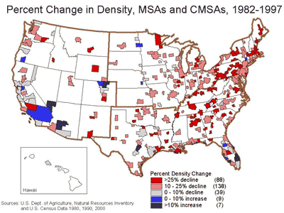 Metropolitan areas in the Northeast and Midwest are consuming land at a much greater rate than they are adding population, and so their "marginal" density is extremely low. (Although they are adding population, Southern metro areas also have low marginal densities.) At the same time, the auto-oriented metropolitan areas of the West have overall metropolitan densities that are comparable to those in the Northeast and the Midwest. Furthermore, they are currently growing at much higher densities than their counterparts anywhere else in the nation. Western metro areas - whatever else their characteristics may be - are using less land to accommodate population growth than metro areas in any other part of the nation.
There is no single problem of "sprawl" in the United States today; and there is no single solution. Rather, the problems associated with metropolitan growth throughout the nation are characterized by regional differences, and policy responses should be different as well.
William Fulton is President of the Solimar Research Group. Rolf Pendall is an Assistant Professor in the Department of City & Regional Planning at Cornell University and a Senior Research Associate at the Solimar Research Group. Mai Nguyen is a Ph.D. student in the Department of Urban Planning at the University of California, Irvine, and a Research Associate at the Solimar Research Group. Alicia Harrison is a Research Associate at the Solimar Research Group. This article was prepared from "Who Sprawls Most? How Growth Patterns Differ Across the U.S.," which was prepared for the Brookings Institution Center on Urban and Metropolitan Policy.


Maui's Vacation Rental Debate Turns Ugly
Verbal attacks, misinformation campaigns and fistfights plague a high-stakes debate to convert thousands of vacation rentals into long-term housing.

Planetizen Federal Action Tracker
A weekly monitor of how Trump’s orders and actions are impacting planners and planning in America.

San Francisco Suspends Traffic Calming Amidst Record Deaths
Citing “a challenging fiscal landscape,” the city will cease the program on the heels of 42 traffic deaths, including 24 pedestrians.

Defunct Pittsburgh Power Plant to Become Residential Tower
A decommissioned steam heat plant will be redeveloped into almost 100 affordable housing units.

Trump Prompts Restructuring of Transportation Research Board in “Unprecedented Overreach”
The TRB has eliminated more than half of its committees including those focused on climate, equity, and cities.

Amtrak Rolls Out New Orleans to Alabama “Mardi Gras” Train
The new service will operate morning and evening departures between Mobile and New Orleans.
Urban Design for Planners 1: Software Tools
This six-course series explores essential urban design concepts using open source software and equips planners with the tools they need to participate fully in the urban design process.
Planning for Universal Design
Learn the tools for implementing Universal Design in planning regulations.
Heyer Gruel & Associates PA
JM Goldson LLC
Custer County Colorado
City of Camden Redevelopment Agency
City of Astoria
Transportation Research & Education Center (TREC) at Portland State University
Jefferson Parish Government
Camden Redevelopment Agency
City of Claremont