


An annual list from American Rivers highlights the waterways most at risk from climate change, poor water management, pollution, and other dangers.
American Rivers has issued its list of America’s Most Endangered Rivers of 2023, an annual survey of the nation’s imperiled waterways.
At the top, unsurprisingly, is the Colorado River segment running through the Grand Canyon, where “rising temperatures and severe drought driven by climate change, combined with outdated river management and overallocation of limited water supplies, put this iconic river at serious risk.”
Other threatened rivers include the Ohio River, whose fragile status was highlighted by the recent East Palestine train derailment that polluted the waterway. “This ongoing chemical disaster underscores the vulnerability of the Ohio River and need for increased safeguards and durable funding for additional and continuous monitoring.”
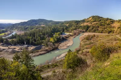
In Georgia, a proposed uranium mine threatens the unique Okefenokee Swap, a wetland spanning almost half a million acres. In California, the Eel River’s abundant fish and wildlife is dwindling thanks to a pair of defunct dams.
The organization recommends that the federal government designate certain rivers as federally protected water systems, strengthen wetlands protections in the Clean Water Act, and mandate the removal of decommissioned dams, among other actions. See the source article for the full list and more information on efforts to protect U.S. rivers.
FULL STORY: Most Endangered Rivers of 2023


GAO: Washington State Slow on Clean Water Reporting
The Clean Water Act mandates reporting of ‘impaired waters’ to support conservation and restoration efforts.
California Lawmakers Move to Protect Waterways
Anticipating that the Trump EPA will reinstate a 2017 policy that excluded seasonal wetlands and waterways from environmental protections.
Biden Administration Seeks More Protection for Wetlands
In a reversal from Trump-era policy, the Biden administration wants to reinstate protections that prevent the contamination of streams and waterways.

Maui's Vacation Rental Debate Turns Ugly
Verbal attacks, misinformation campaigns and fistfights plague a high-stakes debate to convert thousands of vacation rentals into long-term housing.

Planetizen Federal Action Tracker
A weekly monitor of how Trump’s orders and actions are impacting planners and planning in America.

In Urban Planning, AI Prompting Could be the New Design Thinking
Creativity has long been key to great urban design. What if we see AI as our new creative partner?

How Trump's HUD Budget Proposal Would Harm Homelessness Response
Experts say the change to the HUD budget would make it more difficult to identify people who are homeless and connect them with services, and to prevent homelessness.

The Vast Potential of the Right-of-Way
One writer argues that the space between two building faces is the most important element of the built environment.

Florida Seniors Face Rising Homelessness Risk
High housing costs are pushing more seniors, many of them on a fixed income, into homelessness.
Urban Design for Planners 1: Software Tools
This six-course series explores essential urban design concepts using open source software and equips planners with the tools they need to participate fully in the urban design process.
Planning for Universal Design
Learn the tools for implementing Universal Design in planning regulations.
Gallatin County Department of Planning & Community Development
Heyer Gruel & Associates PA
JM Goldson LLC
Mpact (founded as Rail~Volution)
City of Camden Redevelopment Agency
City of Astoria
Jefferson Parish Government
Camden Redevelopment Agency
City of Claremont