


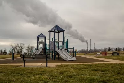
An investigation by ProPublica has produced something the U.S. Environmental Protection Agency has never been able to complete: a nationwide map of the cancer risks created by industrial sources of air pollution.
Al Shaw and Lylla Younes reveal the findings of a new ProPublica analysis into the toxic air pollution emitted into communities around the country.
Here's how Shaw and Younes summarize the investigation and the findings:
ProPublica’s analysis of five years of modeled EPA data identified more than 1,000 toxic hot spots across the country and found that an estimated 250,000 people living in them may be exposed to levels of excess cancer risk that the EPA deems unacceptable.
According to the article, the U.S. Environmental Protection Agency collects data from facilities known to emit large amounts of toxic air pollution, but the agency has never released thus data.
To finally publishing this data for public consumption, the source article (also linked below) maps cancer risk from industrial pollution.
The big, interactive coverage of the investigation also includes a separate article, credited to Younes and Shaw in addition to Lisa Song and Maya Miller. Here's how that article summarizes the stakes of the data revealed by the investigation:
From the urban sprawl of Houston to the riverways of Virginia, air pollution from industrial plants is elevating the cancer risk of an estimated quarter of a million Americans to a level the federal government considers unacceptable.
FULL STORY: The Most Detailed Map of Cancer-Causing Industrial Air Pollution in the U.S.


The Trump Administration's Environmental Policies Have Consequences for Black Lives
A Trump administration decision not to tighten Clean Air Act restrictions on soot pollution will have more consequences for Black Americans.

EPA Relaxes Environmental Rules, Cites Coronavirus
During the outbreak, the agency will allow companies to monitor themselves for pollution violations.

U.S. Air Quality Declining, Taking Lives
Particulate matter air pollution has been on the rise since 2017, according to new research. Wildfires, economic activity, and lax regulation are potentially to blame.

Maui's Vacation Rental Debate Turns Ugly
Verbal attacks, misinformation campaigns and fistfights plague a high-stakes debate to convert thousands of vacation rentals into long-term housing.

Planetizen Federal Action Tracker
A weekly monitor of how Trump’s orders and actions are impacting planners and planning in America.

In Urban Planning, AI Prompting Could be the New Design Thinking
Creativity has long been key to great urban design. What if we see AI as our new creative partner?

King County Supportive Housing Program Offers Hope for Unhoused Residents
The county is taking a ‘Housing First’ approach that prioritizes getting people into housing, then offering wraparound supportive services.

Researchers Use AI to Get Clearer Picture of US Housing
Analysts are using artificial intelligence to supercharge their research by allowing them to comb through data faster. Though these AI tools can be error prone, they save time and housing researchers are optimistic about the future.

Making Shared Micromobility More Inclusive
Cities and shared mobility system operators can do more to include people with disabilities in planning and operations, per a new report.
Urban Design for Planners 1: Software Tools
This six-course series explores essential urban design concepts using open source software and equips planners with the tools they need to participate fully in the urban design process.
Planning for Universal Design
Learn the tools for implementing Universal Design in planning regulations.
planning NEXT
Appalachian Highlands Housing Partners
Gallatin County Department of Planning & Community Development
Mpact (founded as Rail~Volution)
City of Camden Redevelopment Agency
City of Astoria
City of Portland
City of Laramie