


A civil engineer outlines the federal regulations and mechanisms aimed at preventing the damage and loss of life seen in the Francis Scott Key Bridge collapse.
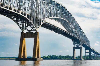
In an interview with Governing, civil engineer Sherif El-Tawil explains how bridges can be built to better withstand ship collisions like the one that damaged the Francis Scott Key Bridge in Baltimore on March 26.
El-Tawil explains that a similar collision in 1980 prompted new federal regulations that took effect in the early 1990s — three years after the Baltimore bridge was built. “What those specifications say is that you either design the bridge for the impact force that a ship can deliver or you must protect the bridge against that impact force. So you must have a protective system.”
El-Tawil notes that such ship collisions are extremely rare, which could explain the lack of expensive protective mechanisms on the Key Bridge. Still, the loss of the bridge will have a major impact on shipping and the national supply chain. “The loss of this bridge, beyond the tragic loss of life, is going to be felt for many months if not years. It’s not a straightforward process to replace a bridge of this magnitude, of this span distance. It’s something that will require a lot of planning and a lot of resources to come back again to where we were before.”
FULL STORY: How Bridges Can Be Protected From Ship Collisions


Baltimore Traffic Suffering From Absence of Key Bridge
The loss of a key route to the Port of Baltimore is causing major delays and long detours on alternate routes.

Baltimore Ordered to Improve Sidewalk Accessibility
The city is one of many to face lawsuits for failing to comply with the Americans with Disabilities Act.
Massachusetts Gov. Makes Case for Road Funding Reforms
A package of proposed bills would change the state’s road funding formula to ensure more money flows to rural areas with limited resources.

Maui's Vacation Rental Debate Turns Ugly
Verbal attacks, misinformation campaigns and fistfights plague a high-stakes debate to convert thousands of vacation rentals into long-term housing.

Planetizen Federal Action Tracker
A weekly monitor of how Trump’s orders and actions are impacting planners and planning in America.

Chicago’s Ghost Rails
Just beneath the surface of the modern city lie the remnants of its expansive early 20th-century streetcar system.

Bend, Oregon Zoning Reforms Prioritize Small-Scale Housing
The city altered its zoning code to allow multi-family housing and eliminated parking mandates citywide.

Amtrak Cutting Jobs, Funding to High-Speed Rail
The agency plans to cut 10 percent of its workforce and has confirmed it will not fund new high-speed rail projects.

LA Denies Basic Services to Unhoused Residents
The city has repeatedly failed to respond to requests for trash pickup at encampment sites, and eliminated a program that provided mobile showers and toilets.
Urban Design for Planners 1: Software Tools
This six-course series explores essential urban design concepts using open source software and equips planners with the tools they need to participate fully in the urban design process.
Planning for Universal Design
Learn the tools for implementing Universal Design in planning regulations.
planning NEXT
Appalachian Highlands Housing Partners
Mpact (founded as Rail~Volution)
City of Camden Redevelopment Agency
City of Astoria
City of Portland
City of Laramie