


The auto-centric development patterns of American cities are a result of decades of misguided, but reversible, policy decisions.
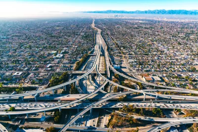
The sprawl that characterizes many modern cities doesn’t have to continue to define them, argues Jocelyn Timperley. “As the world struggles to undo unsustainable systems, as well as the growing inequality between the rich and the poor, cities are making their way back into the spotlight as potential solutions—and missteps.”
Sprawl, as defined in the article by “low-density housing, segregated land uses (meaning housing is separated from shops, workplaces, schools and leisure activities), a lack of local town centers, and limited street connectivity,” increases carbon emissions from transportation and large, single-family homes with bigger carbon footprints. Reid Ewing, professor of city and metropolitan planning at the University of Utah, estimates that “more compact development in the US would lead to a 7 to 10 percent reduction in total transportation carbon dioxide emissions (the largest source of emissions by sector in the US) by 2050, compared to continuing urban sprawl.” Meanwhile, “As of 2015, a single-family detached home in the US used around three times as much energy as an apartment in a building of five or more different units.”
Timperley outlines the history of sprawl in the United States, from its beginnings in early 20th century zoning codes to the suburban boom of the post-World War II era, and how infrastructure spending perpetuates car-centric development.
The article goes on to offer a range of solutions, from relatively inexpensive fixes like crosswalks and bike lanes to major public transit projects and zoning reforms.
FULL STORY: Urban sprawl defines unsustainable cities, but it can be undone


Data Center Emissions Far Outpace Tech Company Claims
In-house data centers owned by several major tech companies likely produce over six times as many greenhouse gas emissions as their owners estimate.
How Zoning Affects Greenhouse Gas Emissions
As the urgency of the climate crisis increases, a paper in the Notre Dame Law Review argues that increased density is not a universally effective strategy to reduce emissions and that different strategies are needed for low-carbon places versus high-carbon ones.

Essay: Will America Ever Change its Urban Patterns?
If there has ever been a good time to change our urban patterns, the time is now.

Maui's Vacation Rental Debate Turns Ugly
Verbal attacks, misinformation campaigns and fistfights plague a high-stakes debate to convert thousands of vacation rentals into long-term housing.

Planetizen Federal Action Tracker
A weekly monitor of how Trump’s orders and actions are impacting planners and planning in America.

Chicago’s Ghost Rails
Just beneath the surface of the modern city lie the remnants of its expansive early 20th-century streetcar system.

Bend, Oregon Zoning Reforms Prioritize Small-Scale Housing
The city altered its zoning code to allow multi-family housing and eliminated parking mandates citywide.

Amtrak Cutting Jobs, Funding to High-Speed Rail
The agency plans to cut 10 percent of its workforce and has confirmed it will not fund new high-speed rail projects.

LA Denies Basic Services to Unhoused Residents
The city has repeatedly failed to respond to requests for trash pickup at encampment sites, and eliminated a program that provided mobile showers and toilets.
Urban Design for Planners 1: Software Tools
This six-course series explores essential urban design concepts using open source software and equips planners with the tools they need to participate fully in the urban design process.
Planning for Universal Design
Learn the tools for implementing Universal Design in planning regulations.
planning NEXT
Appalachian Highlands Housing Partners
Mpact (founded as Rail~Volution)
City of Camden Redevelopment Agency
City of Astoria
City of Portland
City of Laramie