


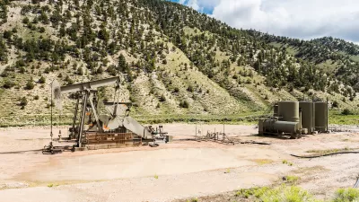
A major challenge facing oil companies in the Uinta Basin is how to transport the crude to market. Alignments have been winnowed and the mode appears to be selected - rail. Total cost: $2 billion to extract $30 billion worth of oil and gas reserves.
Shale oil is associated with fracking. Mining oil shale, on the other hand, some may recall, was an expensive project undertaken by President Jimmy Carter that ended in failure. He may have been 30 years ahead of his time. Oil sands, also called tar sands, are mined in Alberta, Canada and may be transported to Gulf area refineries via the controversial Keystone XL Pipeline pending a decision by President Obama.
An oil shale project in the environmental review process is located in Utah's Uinta Basin. "After studying 26 possible routes for a rail line to transport crude oil from the Uinta Basin, the Utah Department of Transportation (UDOT) revealed Friday (June 13) that only one is feasible," writes Lee Davidson about the Uinta Basin Energy and Transportation Study.
That is a 100-mile route southwest to Price would require a 10-mile tunnel through mountains. [See map inset.] It could connect with national rail lines near Price, and take oil to Wasatch Front refineries or anywhere else in the nation to expand Utah energy markets.
Energy development would be lucrative for the state, according to the study results.
The study concluded that there is over $30 billion worth of energy development potential in the Basin. If this potential is realized, it could generate $10 billion of economic revenue and 27,000 jobs statewide over the next 30 years.
However, transport costs will be considerable, explained John Thomas, UDOT project manager for the Uinta Basin rail environmental impact statement (EIS) process. "National averages predict a construction cost of $10 million per mile for the main line, plus $100 million a mile for the tunnel — for a rough estimate of $2 billion overall."
According to a phone call with state Sen. Kevin Van Tassell, chairman of the Senate Transportation and Public Utilities and Technology Committee, a public-private type of partnership would likely finance the transport project.
Last August, Davidson's colleague, Brian Maffly, wrote about groundwater impacts described in the permitting process:
The proposed permit, which puts Utah a step closer to seeing its vast shale deposits mined on an industrial scale for the first time, would excuse Red Leaf Resources from full-scale groundwater monitoring because the company's process doesn't use water, the spent ore is dry and not much groundwater moves through the project area — a finding environmentalists dispute.
The project is not without opposition, as we noted in January.
Gaylen Webb wrote about the Springs Oil Sands project in the Uinta Basin for Utah Business in November, 2012. Earlier, the Utah Water Quality Board approved the first ever tar sands mine on U.S. soil.
FULL STORY: Wells to rails: Utah may build $2 billion line to ship oil

Utah Oil Shale Extraction Dealt Major Setback
The Surface Transportation Board's approval in 2021 of a proposed 85-mile Uinta Basin Railway in Utah that would have enabled increased extraction of the world's largest source of oil shale was partially vacated by a federal appeals court last month.
Albany Not so Warm to Crude-By-Rail After All
The Port of Albany is thriving as a major hub for CBR shipments from the Bakken field in North Dakota and Saskatchewan province. But we learn there are limits to further growth after the city slapped a moratorium on expansion to oil sands from Canada
A Reversal of Direction for TransCanada
TransCanada, the company that hoped to build a Canada-to-Gulf Coast pipeline, now wants to build one to carry Bakken oil from North Dakota to Canada, transporting oil now hauled only by trains that have caused recent deadly explosions.

Maui's Vacation Rental Debate Turns Ugly
Verbal attacks, misinformation campaigns and fistfights plague a high-stakes debate to convert thousands of vacation rentals into long-term housing.

Planetizen Federal Action Tracker
A weekly monitor of how Trump’s orders and actions are impacting planners and planning in America.

In Urban Planning, AI Prompting Could be the New Design Thinking
Creativity has long been key to great urban design. What if we see AI as our new creative partner?

King County Supportive Housing Program Offers Hope for Unhoused Residents
The county is taking a ‘Housing First’ approach that prioritizes getting people into housing, then offering wraparound supportive services.

Researchers Use AI to Get Clearer Picture of US Housing
Analysts are using artificial intelligence to supercharge their research by allowing them to comb through data faster. Though these AI tools can be error prone, they save time and housing researchers are optimistic about the future.

Making Shared Micromobility More Inclusive
Cities and shared mobility system operators can do more to include people with disabilities in planning and operations, per a new report.
Urban Design for Planners 1: Software Tools
This six-course series explores essential urban design concepts using open source software and equips planners with the tools they need to participate fully in the urban design process.
Planning for Universal Design
Learn the tools for implementing Universal Design in planning regulations.
planning NEXT
Appalachian Highlands Housing Partners
Mpact (founded as Rail~Volution)
City of Camden Redevelopment Agency
City of Astoria
City of Portland
City of Laramie