


Seattle is a city of grids (plural). Downtown, alone, contains three, making for some pretty interesting transportation challenges. Some argue it's simply part of what makes the city livable.
Seattle, like most American cities is built to a grid. Still, in this Northwestern metropolis, distinct changes in the orientation of the city's many clashing grids creates unique transportation challenges. "Our city of hills and water is also a city of broken streets," writes Knute Berger. "We're less multi-modal than we are modal-maniacs. We've never met a mode of transportation we don't believe will free us from the challenges of being gridlocked in a landscape that was never flat, never open, and never dry."
Blame Seattle's grid problems on early city founders and developers, says Berger. From the first developers, and their differing visions for the ideal orientation of the grid, to the Olmsteds, who designed the sweeping, and beautifully curving, parkways, Seattle's streets have long been disjointed.
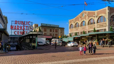
Still, "I wish Seattle had less grid," says Berger. "I wish it were more like a Tuscan hill town or a landscape of organic patterns like rural India, which sometimes looks from the air as if it was grown in a petri dish. We could do with more ground-level irregularity on the human-scale; it would create more interest and variety on the streets (and it's one reason the Pike Place Market is so satisfying)."
FULL STORY: The Case for Keeping Seattle's Streets Messy

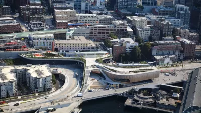
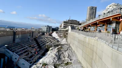
Seattle’s New Overlook Walk Offers Ample Park Space Near Pike Place Market
The elevated park and event space replaces part of the demolished Alaskan Way Viaduct, connecting the city’s famous Pike Place Market to the waterfront.
A Permanent Decline in Revenue Forecasted for the Tunnel Bertha Built in Seattle
Public transit isn't the only mode struggling to attract the expected number of users in 2022. State Route 99 in Downtown Seattle is also failing to live up to expectations and struggling to make ends meet.
The 5 Worst Streets in Seattle
Want to know which streets are most likely to produce a negative emotional response among Seattle transportation safety advocates? Read on.

Planetizen Federal Action Tracker
A weekly monitor of how Trump’s orders and actions are impacting planners and planning in America.

Map: Where Senate Republicans Want to Sell Your Public Lands
For public land advocates, the Senate Republicans’ proposal to sell millions of acres of public land in the West is “the biggest fight of their careers.”

Restaurant Patios Were a Pandemic Win — Why Were They so Hard to Keep?
Social distancing requirements and changes in travel patterns prompted cities to pilot new uses for street and sidewalk space. Then it got complicated.

Platform Pilsner: Vancouver Transit Agency Releases... a Beer?
TransLink will receive a portion of every sale of the four-pack.

Toronto Weighs Cheaper Transit, Parking Hikes for Major Events
Special event rates would take effect during large festivals, sports games and concerts to ‘discourage driving, manage congestion and free up space for transit.”

Berlin to Consider Car-Free Zone Larger Than Manhattan
The area bound by the 22-mile Ringbahn would still allow 12 uses of a private automobile per year per person, and several other exemptions.
Urban Design for Planners 1: Software Tools
This six-course series explores essential urban design concepts using open source software and equips planners with the tools they need to participate fully in the urban design process.
Planning for Universal Design
Learn the tools for implementing Universal Design in planning regulations.
Heyer Gruel & Associates PA
JM Goldson LLC
Custer County Colorado
City of Camden Redevelopment Agency
City of Astoria
Transportation Research & Education Center (TREC) at Portland State University
Camden Redevelopment Agency
City of Claremont
Municipality of Princeton (NJ)