


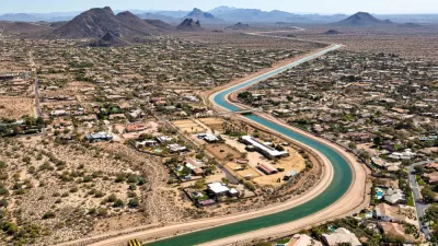
A new branch of the Lincoln Institute will focus on water planning, especially in the western United States.

The Lincoln Institute of Land Policy has launched the Babbitt Center for Land and Water Policy, a new think tank meant to integrate water and land-use planning. Based in Phoenix, the center's mission is to "advance water sustainability through improved land use planning, management and decision making."
The Babbitt Center will work at the local level with municipalities throughout the Colorado River Basin to "gather data, develop indicators, and build and test new tools for fair, efficient, and sustainable management of water resources," according to the announcement. For example:
An initial activity will be to develop a map, using satellite imagery, for selected tributaries of the Colorado River Basin. The aim is to provide a foundation – potentially scaled up to the entire basin, serving seven states and some 30 million people – that illustrates the relationship between land and water, and can be used for better projections, modeling, and scenario planning.
The Lincoln Institute is also adjusting its partnership with the Sonoran Institute—formerly known as Western Lands and Communities—to focus on local land-use planning and water management under the name Resilient Communities and Watersheds.
FULL STORY: Think tank aims to bolster water planning

New Map Deepens Understanding of Cross-Border Aquifers
A new analysis of U.S. and Mexico groundwater supplies reveals 72 aquifers shared between the two countries.
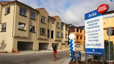
Local Solutions for Housing Affordability
The Lincoln Institute of Land Policy recently published a report to identify local government actions to ensure stable and affordable places to live for everyone.

A New Tool for More Flexible and Resilient Water Policies
A new book created by the Sonoran Institute explains how exploratory scenario planning can be useful to prepare for the uncertainty of water in the near- and long-term future.

Maui's Vacation Rental Debate Turns Ugly
Verbal attacks, misinformation campaigns and fistfights plague a high-stakes debate to convert thousands of vacation rentals into long-term housing.

Planetizen Federal Action Tracker
A weekly monitor of how Trump’s orders and actions are impacting planners and planning in America.

In Urban Planning, AI Prompting Could be the New Design Thinking
Creativity has long been key to great urban design. What if we see AI as our new creative partner?

King County Supportive Housing Program Offers Hope for Unhoused Residents
The county is taking a ‘Housing First’ approach that prioritizes getting people into housing, then offering wraparound supportive services.

Researchers Use AI to Get Clearer Picture of US Housing
Analysts are using artificial intelligence to supercharge their research by allowing them to comb through data faster. Though these AI tools can be error prone, they save time and housing researchers are optimistic about the future.

Making Shared Micromobility More Inclusive
Cities and shared mobility system operators can do more to include people with disabilities in planning and operations, per a new report.
Urban Design for Planners 1: Software Tools
This six-course series explores essential urban design concepts using open source software and equips planners with the tools they need to participate fully in the urban design process.
Planning for Universal Design
Learn the tools for implementing Universal Design in planning regulations.
planning NEXT
Appalachian Highlands Housing Partners
Mpact (founded as Rail~Volution)
City of Camden Redevelopment Agency
City of Astoria
City of Portland
City of Laramie