


For the second time in its history, Louisville completed an ambitious and massive park planning and design process on its suburban fringe. The fringe today is just a bit farther out than it was in Olmsted's day.

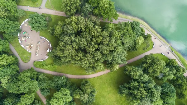
Jen Kinney writes that this month in Louisville, "nonprofit 21st Century Parks is celebrating the completion of a new greenway on Louisville’s now expanded limits, the city’s first major public-private partnership to construct new parks." All told, the Parklands of Floyds Fork cost $125 million, creating 2,000 acres and nearly 20 miles of continuous parkways.
As Kinney notes, the new park is an echo of the park planning of Louisville's past: over 100 years ago, "Frederick Law Olmsted designed a system of 18 parks linked by 14.5 miles of greenery-ed boulevards around the then-urban edges of Louisville…"
Now the suburban edge of the city is decidedly farther out from the urban core, on land requiring a very involved series of transactions to assemble. According to Kinney, "21st Century Parks engaged in 80 separate land transactions with a variety of owners to piece together the park over the course of eight years. None of the land was acquired by eminent domain or condemnation."
The article includes more details about the amenities and facilities included in the completed park. City officials are expecting 2 million visitors to the park this year.
FULL STORY: Louisville Looks to the Edges for New Parks, Once Again

Not a Walk in the Park: What It Really Takes to Build Green Spaces
Park creation can take decades of perseverance to overcome financial, regulatory, and social hurdles, but the end result for the local community is more than worth it.

Envisioning a New Park in East Los Angeles
Los Angeles County is working towards transforming underutilized land into a vibrant pocket park in the City Terrace neighborhood of East LA.

Using Cellphone and Fitness App Data for Park Planning
Data from smartphone apps and fitness trackers are helping planners to better understand park usage patterns and plan for new and improved parks.

Planetizen Federal Action Tracker
A weekly monitor of how Trump’s orders and actions are impacting planners and planning in America.

Chicago’s Ghost Rails
Just beneath the surface of the modern city lie the remnants of its expansive early 20th-century streetcar system.

Amtrak Cutting Jobs, Funding to High-Speed Rail
The agency plans to cut 10 percent of its workforce and has confirmed it will not fund new high-speed rail projects.

Ohio Forces Data Centers to Prepay for Power
Utilities are calling on states to hold data center operators responsible for new energy demands to prevent leaving consumers on the hook for their bills.

MARTA CEO Steps Down Amid Citizenship Concerns
MARTA’s board announced Thursday that its chief, who is from Canada, is resigning due to questions about his immigration status.

Silicon Valley ‘Bike Superhighway’ Awarded $14M State Grant
A Caltrans grant brings the 10-mile Central Bikeway project connecting Santa Clara and East San Jose closer to fruition.
Urban Design for Planners 1: Software Tools
This six-course series explores essential urban design concepts using open source software and equips planners with the tools they need to participate fully in the urban design process.
Planning for Universal Design
Learn the tools for implementing Universal Design in planning regulations.
Caltrans
City of Fort Worth
Mpact (founded as Rail~Volution)
City of Camden Redevelopment Agency
City of Astoria
City of Portland
City of Laramie