


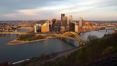
Once controlled by "industrial behemoths", Christine H. O'Toole examines the role that Pittsburgh's three rivers - its genius loci - have played in spurring the redevelopment of the city's downtown.
The Allegheny, Monongahela and Ohio are the reason that Pittsburgh exists, says O'Toole, who looks at efforts over the last two decades to clean up what were until fairly recently terribly polluted industrial dumping grounds, and turn them into the focus of the city's renaissance. "The city has managed to leverage a $124 million investment in publicly accessible riverfront into $4 billion in corporate, public, nonprofit and entertainment development downtown," she notes. "That success has renewed a debate that would have been unthinkable in Pittsburgh’s polluted industrial heyday: how best to expand public access to the shorelines of the three rivers."
Two decades of clearing and cleaning has restored the rivers' luster, and competing interests are now vying to utilize the newly attractive riverfront. "Projects proposed for two of the largest tracts left to be developed on the downtown fringe illustrate the opportunities and limits of public-private partnerships," writes O'Toole, who details the conflicts that arise when the interests of developers, city leaders, and citizens don't align.
FULL STORY: Pittsburgh’s Three Rivers, Now a Public Attraction


Master Plan Strives for a 'Seamless' Chattahoochee River for the Atlanta Region
A comprehensive study to revitalize the Atlanta regional waterfront, dubbed the Chattahoochee RiverLands project, is now underway.
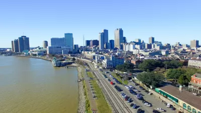
New Orleans Closes Gap in Historic Riverfront Park Plan
New Orleans could create the largest stretch of public riverfront in the U.S., thanks to a public land swap.
Pittsburgh Redevelopment Happening on Riverfront Property
With the economic benefit of redevelopment along Pittsburgh's river well understood, it's time to survey all the new and reused riverfront properties coming online.

Maui's Vacation Rental Debate Turns Ugly
Verbal attacks, misinformation campaigns and fistfights plague a high-stakes debate to convert thousands of vacation rentals into long-term housing.

Planetizen Federal Action Tracker
A weekly monitor of how Trump’s orders and actions are impacting planners and planning in America.

Chicago’s Ghost Rails
Just beneath the surface of the modern city lie the remnants of its expansive early 20th-century streetcar system.

Bend, Oregon Zoning Reforms Prioritize Small-Scale Housing
The city altered its zoning code to allow multi-family housing and eliminated parking mandates citywide.

Amtrak Cutting Jobs, Funding to High-Speed Rail
The agency plans to cut 10 percent of its workforce and has confirmed it will not fund new high-speed rail projects.

LA Denies Basic Services to Unhoused Residents
The city has repeatedly failed to respond to requests for trash pickup at encampment sites, and eliminated a program that provided mobile showers and toilets.
Urban Design for Planners 1: Software Tools
This six-course series explores essential urban design concepts using open source software and equips planners with the tools they need to participate fully in the urban design process.
Planning for Universal Design
Learn the tools for implementing Universal Design in planning regulations.
planning NEXT
Appalachian Highlands Housing Partners
Mpact (founded as Rail~Volution)
City of Camden Redevelopment Agency
City of Astoria
City of Portland
City of Laramie