


Planning Support Tools have the potential to revolutionize the way we do planning. Yet many planners have been slow to adopt them. Why aren't these cutting-edge planning tools in the mainstream planner's toolbox?
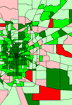 Planning Support Tools are a collection of technologies that enable planners and policy makers to visualize and evaluate alternative futures for their cities and regions, and to enhance the level of public participation in the planning process.
Planning practitioners from around the country convened in October, 2001 in Denver at the fourth in a series of national meetings on tools for community design and decision-making. This loose confederation of tool providers and users gathers periodically to share experiences, examine the state-of-the-art, and generally advocate greater tool use (www.i4sd.org/TCDDM). The group is interested in promoting tools for civic engagement, urban design and visualization, and sustainable resource management, and ranging from software models to public participation techniques.
 Many in Denver were asking why these tools aren't used more often in more communities. Why haven't they been mainstreamed, and what are the barriers to greater acceptance by planning practitioners? There are five major influences working against tool adoption:
- Tool design. A disproportionate number of tools are focused on conceptual planning at the front-end of community development, with little attention to the later critical stages of plan implementation and performance monitoring. Also, tool design often happens without input from decision makers who will be the ultimate users, raising questions about tool relevance to real world issues
- Technology. It doesn't always work, and even then it is often considered too difficult or complex for frequent or ongoing use.
- Data. There are still enormous problems with availability and quality. These are compounded by a lack of a common standards, especially in multi-jurisdiction regions, and the perception that data maintenance is excessive for ongoing tool use.
- Staff. Many community staff are still technology-shy, but more importantly, they simply don't have enough extra time in their normal workload to learn about, and apply, tools. They also have little real-time experience using tools interactively in public processes.
- Organizations. There is a frequent lack of management support for using tools, which ripples through to the staff climate just described. Also, needed technical resources and skills are often split between organizational units with different priorities.
To make greater inroads into mainstream planning, we should emphasise simple tools that are easily learned, applied, and maintained. In addition to simplicity, tool developers shouldn't forget the less glamorous, but essential, stages of implementation and performance monitoring, which is where many decision makers deviate from adopted plans. Sufficient resources also need to be allocated to data development, and to staff training in applying tools in public processes. A small but important step in many communities would be simply modernizing official hearing rooms with current information technology for use during public deliberations.
Are community design and decision-making tools ready for prime time? They seem to be on the brink of readiness, but closer attention must be paid to the working environments where they'll ultimately be used. There are a variety of exciting and innovative tools emerging in this arena, and with appropriate advocacy and support, they should eventually prove to be critical contributors to better communities.
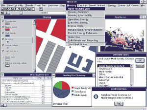
Eliot Allen, AICP, is a Principal at Criterion Planners/Engineers in Portland, Oregon. Criterion is the developer of INDEX, a GIS-based decision support system that uses indicators to measure the attributes and performance of community plans. First introduced in 1994, it is now one of the most widely distributed planning tools in the U.S.


Maui's Vacation Rental Debate Turns Ugly
Verbal attacks, misinformation campaigns and fistfights plague a high-stakes debate to convert thousands of vacation rentals into long-term housing.

Planetizen Federal Action Tracker
A weekly monitor of how Trump’s orders and actions are impacting planners and planning in America.

In Urban Planning, AI Prompting Could be the New Design Thinking
Creativity has long been key to great urban design. What if we see AI as our new creative partner?

King County Supportive Housing Program Offers Hope for Unhoused Residents
The county is taking a ‘Housing First’ approach that prioritizes getting people into housing, then offering wraparound supportive services.

Researchers Use AI to Get Clearer Picture of US Housing
Analysts are using artificial intelligence to supercharge their research by allowing them to comb through data faster. Though these AI tools can be error prone, they save time and housing researchers are optimistic about the future.

Making Shared Micromobility More Inclusive
Cities and shared mobility system operators can do more to include people with disabilities in planning and operations, per a new report.
Urban Design for Planners 1: Software Tools
This six-course series explores essential urban design concepts using open source software and equips planners with the tools they need to participate fully in the urban design process.
Planning for Universal Design
Learn the tools for implementing Universal Design in planning regulations.
planning NEXT
Appalachian Highlands Housing Partners
Mpact (founded as Rail~Volution)
City of Camden Redevelopment Agency
City of Astoria
City of Portland
City of Laramie