


The Strange Maps blog is an eclectic collection of maps, diagrams, and cartoons. Some graphics featured on this blog are informative, some are creative, and others are completely bizarre.The website is maintained by an anonymous blogger. The posted graphic is often accompanied by informative notes. Here is a list of 21 maps that I found interesting:

 The Strange Maps blog is an eclectic collection of maps, diagrams, and cartoons. Some graphics featured on this blog are informative, some are creative, and others are completely bizarre.The website is maintained by an anonymous blogger. The posted graphic is often accompanied by informative notes. Here is a list of 21 maps that I found interesting:
Transit Map of the World's Transit Systems
Cities with urban rail systems.
Driving Orientation: A World Map
The origins of traffic driving on the right or left side of the road.
A Diagram of the Eisenhower Interstate System
Which interstates do not cross state lines?
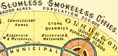
"Slumless, Smokeless Cities"
How geometric can urban planning get?
A Texan's Map of the United States
Don't mess with this map.
The World As Seen From New York's 9th Avenue
A New York state of mind.
GDP Map of the USA
U.S. states labelled as countries with similar GDP.
The Nine Nations of North America
Regions with similar cultural and economic features.
The United Countries of Baseball
You can observe a lot by watching this map.
Shifting Like A Snake: Ancient Mississippi Courses
Nature the artist.
The Patients Per Doctor Map of the World
More effective than presenting data in a table.
World-Wide Web Map, From .ad to .za
What does Los Angeles have in common with Laos?
A Map of the Internet's Black Holes
Countries where internet use is censored or limited.
Online Communities Map (Not For Navigation)
Where do you live on this map?
A Subway Map of Web Trends 2.0
When are they going to release Web 3.0?
UFO Hotspots Map
See where extraterrestrials like to hang out.
The Most Generic Country Ever
A quick geography lesson.
Oh, Inverted World
What if all the land was water?
Where On Earth Was Middle-earth?
One map to rule them all.
Found: a Map of the Island in ‘Lost'
But can it help you make sense of the storyline?
A Simplified Map of London
The simplest map in the collection.
If you have any interesting graphics to share please send it to Strange Maps and help add to this fascinating collection.


Trump Cuts Decimate Mapping Agency
The National Geodetic Survey maintains and updates critical spatial reference systems used extensively in both the public and private sectors.

New Book Shows How Geographic Technology Tackles Global Challenges
In his new book, Jack Dangermond explores the transformative impact of GIS technology in solving global challenges through spatial data, highlighting its widespread application across sectors and its potential to design sustainable futures.

Building Healthier Communities: The Role of GIS in Park Planning
Integrating Geographic Information Systems (GIS) into park planning enhances community health by promoting physical activity, supporting mental well-being, fostering social connectedness, and addressing public health crises and climate change.

Planetizen Federal Action Tracker
A weekly monitor of how Trump’s orders and actions are impacting planners and planning in America.

Chicago’s Ghost Rails
Just beneath the surface of the modern city lie the remnants of its expansive early 20th-century streetcar system.

Amtrak Cutting Jobs, Funding to High-Speed Rail
The agency plans to cut 10 percent of its workforce and has confirmed it will not fund new high-speed rail projects.

Ohio Forces Data Centers to Prepay for Power
Utilities are calling on states to hold data center operators responsible for new energy demands to prevent leaving consumers on the hook for their bills.

MARTA CEO Steps Down Amid Citizenship Concerns
MARTA’s board announced Thursday that its chief, who is from Canada, is resigning due to questions about his immigration status.

Silicon Valley ‘Bike Superhighway’ Awarded $14M State Grant
A Caltrans grant brings the 10-mile Central Bikeway project connecting Santa Clara and East San Jose closer to fruition.
Urban Design for Planners 1: Software Tools
This six-course series explores essential urban design concepts using open source software and equips planners with the tools they need to participate fully in the urban design process.
Planning for Universal Design
Learn the tools for implementing Universal Design in planning regulations.
Caltrans
City of Fort Worth
Mpact (founded as Rail~Volution)
City of Camden Redevelopment Agency
City of Astoria
City of Portland
City of Laramie