The physical layout of infrastructure is the quiet force that shapes housing supply.


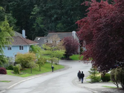
In response to mounting pressure to increase housing supply and make housing more affordable, municipalities are updating official plans and zoning bylaws and expanding permissions for a broader range of housing types. While this is a great start, in many growing communities — especially on greenfield sites and on the edges of cities — zoning is only part of what determines the final outcome.
A city may permit residential development yet still produce fewer homes than expected because of how it is laid out. This highlights a critical blind spot often ignored in the housing discussion: the fact that street hierarchy and rights-of-way guidelines all dictate what can actually be built. By the time those decisions are made, much of the housing outcome is already fixed, locking in sprawl and car dependency for generations to come.
Municipalities focus on land use permissions, but those permissions are filtered through subdivision standards that were developed for a different set of priorities. If the standards governing neighborhood structure and streetscapes remain unchanged, zoning reform alone will not meaningfully shift housing outcomes.
Design translates policy into physical form
Planning conversations about housing typically begin with use and density. Can the site accommodate detached homes, townhouses or apartments? What unit count is permitted? Those are all necessary questions, but they do not resolve the physical question of how the land will be organized. That question is answered through design.
In that sense, subdivision design is not just a technical step following planning policy. It is one of the main mechanisms through which planning policy is translated into physical form.
Once a street network is established, the site's usability begins to narrow. Two sites with similar zoning can perform very differently depending on how they are structured. One may accommodate a more efficient pattern of development with more lots, more housing options and a stronger public realm. Another may absorb large amounts of land in oversized rights-of-way, reducing the amount of land available for housing while making future adaptation more difficult.
Infrastructure is not neutral
A common assumption in the approvals process is that subdivision standards are largely neutral. They are used as implementation tools rather than as policy decisions in their own right. But standards are not neutral. They embed a set of priorities into the physical structure of a neighborhood.
Minimum right-of-way widths influence how much land is consumed by infrastructure and how much remains available for the uses we care about. Many of these standards are not oversized because the technical requirements truly demand it. They are oversized because, over time, layer upon layer of assumptions has been added to the design process: "wider is better;" "wider is safer."
We know that that logic does not hold up very well. Wider streets tend to encourage higher vehicle speeds, which undermine safety rather than improve it. At the same time, the actual operational requirements set by fire codes that speak to fire safety and access, snow plowing and servicing are satisfied with much narrower paved widths than those embedded in today’s default standards. The result is a street section that is not simply the product of necessity, but of accumulated assumptions that have gradually normalized more pavement than is actually needed.
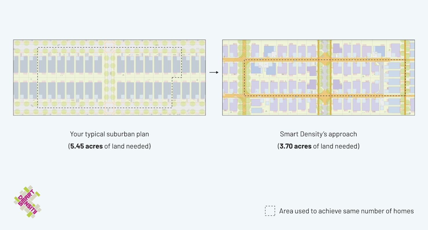
The comparison above shows how much land is tied up in the default suburban development pattern. On the left is a typical Dallas subdivision block, where wide rights-of-way and large setbacks require 5.45 acres to deliver the same number of homes. On the right is the approach of my organization, Smart Density, which delivers the same number of homes on 3.70 acres by right-sizing the street network, reducing front setbacks and using more efficient building footprints while maintaining the same overall floor area. The main goal is not simply to "fit more in." It is to create a better street environment, with land efficiency as a major bonus.
Changing the framework
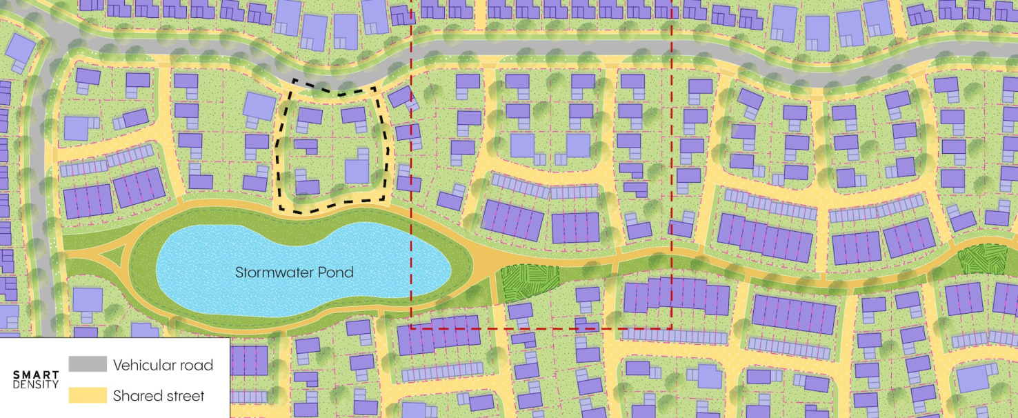
In a recent project in a community near Ottawa, Smart Density’s team explored what would happen if the subdivision framework were approached differently. The conventional pattern for this context would have produced roughly three to five homes per acre, with a standard street hierarchy and larger rights-of-way. Instead, the plan introduced a tighter structure: shorter streets serving fewer homes, more efficient blocks and a stronger pedestrian spine integrated with landscape and stormwater features.
The housing type itself did not fundamentally change. The neighborhood still accommodated detached homes and car access. What changed was the physical framework supporting them.
That shift increased the yield to roughly six homes per acre while also reducing the amount of land devoted to pavement. More of the site remained available for housing, green corridors and shared public space. Just as important, the neighborhood took on a different spatial quality. The public realm felt more intentional, the relationship between homes and the street improved and the plan created a more coherent structure for movement and open space.
How to let neighborhoods evolve
Housing supply should not be measured only by how many units are delivered on day one. It should also be understood in terms of whether a neighborhood can absorb change over time and continue to perform well as conditions evolve.
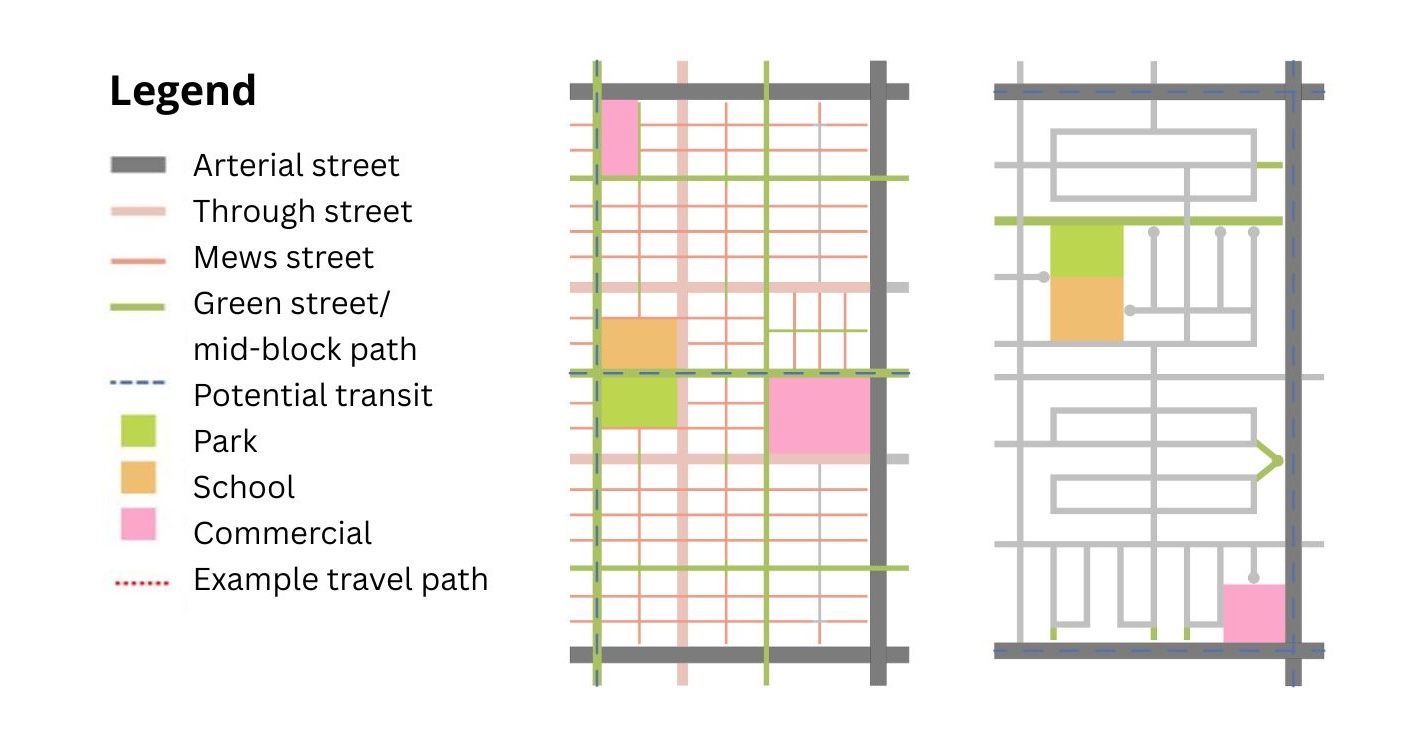
This is one of the clearest differences between older neighborhoods and many contemporary subdivisions. Older areas often have a physical structure that allows for gradual adaptation because smaller blocks create more corners, frontage and points of access, while connected streets create more direct routes for movement and servicing. These conditions make it easier to divide land in different ways, introduce additional units, intensify selected sites, convert buildings or accommodate small local-serving uses over time without having to remake the neighborhood entirely.
Newer subdivisions are less forgiving. Their structure tends to be highly fixed from the outset, limiting the ways a neighborhood can evolve without major disruption. By contrast, a more efficient subdivision framework does more than improve initial yield. It can accommodate the basic elements of low-density suburban life (a house, backyard and parking) while reducing infrastructure needs and creating quieter, more comfortable streets. That kind of structure can also more easily integrate transit service introduced later, which often happens as neighborhoods mature. Over time, it can support change more easily, including some intensification, without triggering the same level of pressure on parking and traffic that conventional patterns tend to produce.
This is why subdivision design should be understood as part of housing strategy: it is not only about how much housing is delivered at the start, but how much capacity a neighborhood retains for the future.
Old habits die hard
Zoning reform remains essential. But if municipalities stop there, they will continue approving neighborhood structures that make housing goals harder to achieve.
Subdivision design is where many of those goals either gain physical form or begin to erode. It affects land efficiency, yield, adaptability, infrastructure burden and the long-term performance of a neighborhood. For that reason, it deserves a much more central place in planning discussions about housing.
At a time when every acre matters, wasting land on unnecessary asphalt is no longer defensible. The tools, examples and alternatives already exist. What continues to stand in the way is not lack of possibility, but the force of old habits. Until those habits are questioned, we will keep reproducing neighborhoods that ask more of the land and deliver less in return.
–
Naama Blonder is an architect, urban planner and urban designer working to reshape what good housing and neighbourhood design can look like across North America. With that in mind, she co-founded Smart Density in 2017. Her work has received numerous awards including the prestigious Ontario Association of Architects’ Best Emerging Practice Award in 2022, the BILD Professional Service Award 2026, the Ontario Professional Planning Institute Award for Public Education in 2024 and was a finalist of Royal Bank of Canada's Women of Influence in 2023.


The Trouble With QUIMBY
The idea of “quality urbanism in my back yard” has its uses, but should not be used to limit housing supply.
To upzone or not to upzone? Two views on the housing crisis
Allowing more density can increase the housing supply, but does the attendant rise in land prices cancel out the benefits?
Less than 6% of California cities are building enough housing for very low-income households
Only five jurisdictions are on track to meet their housing goals for all income brackets.

Planetizen Federal Action Tracker
A weekly monitor of how Trump’s orders and actions are impacting planners and planning in America.

Colorado’s Largest Data Center Could Rise Next to Homes — Without a Public Hearing
The proposed campus would consume 11 times the power of Denver International Airport; as it has across the country, opposition mounts.

US to reduce Colorado River water deliveries to Mexico
A new Colorado Treaty amendment reduces Mexico’s Colorado River water allocation by 250,000 acre feet.

'This is going to be painful:’ Virginia stares down $1.7 billion funding gap for highway maintenance
The state may address the deficit by shifting $290 million from its construction budget to maintenance projects.

Judges permit Denver to divert 77,000 acre feet from the Colorado River for reservoir expansion
Overuse and climate change have caused the Colorado River’s water levels to plummet.

Amtrak, CN end decades-long dispute with eight-year agreement
The new operating agreement establishes an updated framework for the companies to work together, including processes to resolve disputes.

FREE Course: Walkable City 1: Why Walkability?
After describing his path towards focusing on walkability as the essence of good planning, Jeff Speck marches through his five principal reasons for making more walkable places.
Reinventing Malls: Planning Alchemy—Turning Gray Fields Into Gold
The course focuses on the opportunities and imperatives that shape reinvention of mall sites.

KFH Group Inc.
Greater Baltimore Committee
Eagle County Government
The Architects Foundation
University of Cincinnati Online
The Pocatello Development Authority
The Urban Renewal Agency of the City of Pocatello

