Jane Jacobs used vague terms to describe the number of stores necessary for a safe and vibrant streetscape. Here, author Fanis Grammenos attempts to discover a more specific number to attach to this prescription.


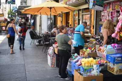
In her 1961 book, Jacobs made daring observations about how the "good city" works. A good number of passages in the book dealt with safety, such as the following, (emphasis is mine):
"The basic requisite for such surveillance [of the street] is a substantial quantity of stores and other public places sprinkled along the sidewalks of a district; enterprises and public places that are used by evening and night must be among them especially. Stores, bars and restaurants, as the chief examples, work in several different and complex ways to abet sidewalk safety."
In a previous article, we quantified Jacobs's "substantial number" of "birds of passage," Jacobs references when discussing the unspecified ratio of transient tenants that a neighborhood can absorb. In the case of stores, "substantial" is just as vague and unhelpful prescription for practice as the previous observation about transient tenants. Though the underlying principle stands, its application could falter for lack of specificity. The task of this article will be to quantify "substantial," identify thresholds of significance, and search for the implications of numerical alternatives to vagueness.
Patterns of sprinkles
Figure 1, which encompasses six neighborhoods in Cambridge, Massachusetts (about 6 km2 ), reveals identifiable patterns: First an obvious disproportionate concentration of storefronts (red dots) along two alignments that run through the district (East-West). Second, a much lower frequency along shorter longitudinal lines and far fewer dispersed dots in the N-S direction. Thirdly, absence of any dots on a high percentage of district streets.

This uneven pattern of storefront distribution, seemingly obscure, becomes fully transparent when understood in the context of the district's circulation pattern. Five bridges (blue B,) linking Cambridge to Boston act as gates to it and beyond. Typically, the longer and more direct a link is to a bridge, the higher the concentration of stores on it. This symbiotic relationship between traffic and commerce is not only fully understood but also a cardinal rule for city and transportation planners. It is also intuitively taken for granted by store owners. Figure 2 gives a numerical interpretation of a network's characteristics that underpin this convention. Drawing upon this chart, it is reasonable to conjecture that commercial enterprises will appear mostly on roads that carry high enough traffic to support them; these routes, as a rule, are major and minor arterials. Indeed, Fig 1 visualizes indirectly a road's characteristic: "arteriality".

Though consistent with the traffic-commerce link, the area in Fig 1 is devoid of dots—an overwhelming majority—astounds by its sheer size. In a mature, compact, connected, and accessible district this dearth of shops is counterintuitive. Fig 3 lists 22 of its 127 streets (17% of total) that possess more than one storefront on their entire length. Setting aside the unfurnished 83%, we ask whether the frequency of stores in the active set qualify as a "substantial quantity." No benchmarks exist to answer this question.

About thresholds
Of the 22 district streets that have storefronts in Figure 3, 18 (80%) are either below or barely above a hypothetical threshold of one storefront per 100 m (300 feet) of street length. Such sporadic incidence hardly matches a common-sense expectation of "substantial number" and "variety" or those of typical sidewalk images of "walkable, vibrant, lively, mixed-use" streets. In spite of the absence of benchmarks, it is almost certain that one storefront per block would be barely adequate for any noteworthy surveillance to materialize; neither by its own presence nor by the number of customers it could attract. Here we face a quantification impasse, or, alternatively, a challenge for more research.

To gain a perspective on store density, we'll look at a set of 12 streets in the downtowns of four cities. There, the concentration of storefronts shown on maps appears the highest as compared to other, surrounding districts. Figure 4 shows storefront frequencies ranging from 1.6 per 300 feet to 7.6, an almost five-fold range, with an average of 4.3. These average and individual rates are much higher than those of Cambridge.
The large range, noticeable peculiarities of the rankings and inconsistencies between individual streets within districts raise intriguing questions. The range poses the question of whether it should be interpreted unquestionably as a linear progression of safety, as the introductory quote implies. If so, then a low threshold below which the street becomes unacceptably unsafe could exist, at least in theory. A paradox also surfaces: in the same mature, compact and diverse districts, streets only a block or two apart show substantially different rates. For example, L.A.s' South Spring Street has approximately one third (1.6) of South Broadway's frequency (4.1). Nearby, Olive Street, Grand Avenue and Hope Street appear to have even lower frequencies. By L.A.'s own better streets figures, they are underperforming.
Another surprising contrast is between the frequencies of central streets in New Orleans that occupy three top tiers and those of L.A.'s (a city 10 times bigger) that hold two median and the lowest positions. Are we to surmise that LA's downtown is less compact, diverse, and lively than New Orleans, or that it lacks sufficient surveillance? It's impossible to judge without an objective scale.
So far, we have wrestled a tentative average storefront frequency from available data but gained little certainty about its meaning or its practical use in neighbourhood planning.
Upgrades and the "invisible hand"
With an average in hand, we can now estimate the number of storefronts that would be needed to upgrade Cambridge's streets, should they be judged as "dull," unsafe, or inadequately furnished. To bring all 18 under-furnished streets to at least one storefront per 100 m, 180 new stores would be required and, to raise the average of all 23 to 4 per 100 m, the number would be 1052. These additions would mean a 50% increase in stores in the first instance and over 300% in the second, a massive addition.
Assuming that these additions were deemed necessary to "improve" the district, based on a set of yet unknown premises, introducing them by fiat would run into an array of procedural obstacles and systemic flaws of top-down planning. More critically, it would defy Jacob's own perspective, now prevalent among planners, that: "When we deal with cities we are dealing with life at its most complex and intense […]." Jacobs emphasized that point by asking "Why have cities not [,… ,] been identified, understood and treated as problems of organized complexity?"
In practical terms, this means that growth and change in city districts follow organic rules, the results of which are indeterminate and which become only clearfollowingtheir manifestation. A pattern in the making has no identifiable shape. "The Invisible Hand" of organic growth is shaping and reshaping the built environment constantly.

For example, Figure 5 shows seven manifestations of unpredictable land-use changes that produced storefronts on three streets. As evidence in all central, mature districts demonstrates, these types of mutations are the rule rather than the exception. The birth, life and death of individual stores unfold "in different and complex ways" and cannot be foreseen, managed, or dictated.
Conclusion
In this brief exploration, we identified at least one numerical equivalent to the vague "sprinkle of stores" recipe but could not establish benchmarks for sufficiency. A street's equivalent of a Body Mass Index(i.e., a "Healthy Store Density and Variety Index") has yet to be invented.
One significant quantity, however, emerged from this analysis. It became evident that, on average, the vast majority of streets—about 70-80%—in any district similar to Cambridge (approx. 6 km2 ) will be devoid of stores; there is simply not enough traffic on every street to nourish them or sufficient local population to support them. This finding implies that most streets will forever be dull, with little variety, and hardly any activity on them, even when they are part of a compact and walkable district. Unremarkable as they may be, they could also be pleasant, safe, and even illustrious. Examples of such good streets abound; Allan Jacobs took notice of some.
In planning and rebuilding, it is unwarranted, and futile, to portray "vibrant, healthy and safe" streets by means of storefront density and diversity; most cannot ever achieve such features, or even close. Such an idealized, reassuring portrayal is most certainly a recipe for disillusionment. The life of streets cannot be drawn on paper or decreed as a policy prescription; it is an emergent quality.
Fanis Grammenos is the director Urban Pattern Associates in Ottawa, Ontario and the author of Remaking the City Grid: A Model for Urban and Suburban Development. Reach him by email with questions or comments.
--------------------
References:
- Nikos A. Salingaros (2003): Connecting the Fractal City (pdf)
- Michael Mehaffy (2017): Cities Alive: Jane Jacobs, Christopher Alexander, and the Roots of the New Urban Renaissance

The State of Commercial Corridors (And How to Protect Them During the Pandemic)
The pandemic is accelerating recent trends in commercial real estate with potentially catastrophic consequences for the commercial corridors that play such a fundamental role in the urban fabric.
Keeping Downtown Main Streets Full
Oakland County, Michigan has announced an initiative to attract and retain retail businesses.
Commercial Corridor Going Car Free in L.A.'s Playa Vista
A proposal to block cars from the Runway in Playa Vista reflects a new approach to user experience in retail environments.

Planetizen Federal Action Tracker
A weekly monitor of how Trump’s orders and actions are impacting planners and planning in America.

Amtrak, CN end decades-long dispute with eight-year agreement
The new operating agreement establishes an updated framework for the companies to work together, including processes to resolve disputes.

Nation's most wind-powered state turns to coal as data centers increase energy demand
For the first time in decades, Iowa has increased its generation of coal power.

Alabama scores up to $2.5 billion federal loan for largest infrastructure project in state’s history
The Mobile River Bridge and Bayway Project aims to ease congestion at Alabama’s worst bottleneck.

Trump is considering data centers on 6 states' public land — some state officials say they had no idea
If the administration approves the proposed projects, data center and data center-related developments will cover 17,600 acres of public land.

Despite court ruling, Trump is keeping nearly all wind projects in the US on hold
At least 110 wind energy projects have not heard from the government since a federal judge ruled that the Trump administration's freeze on wind turbine clearances was likely illegal.

FREE Course: Walkable City 1: Why Walkability?
After describing his path towards focusing on walkability as the essence of good planning, Jeff Speck marches through his five principal reasons for making more walkable places.
Reinventing Malls: Planning Alchemy—Turning Gray Fields Into Gold
The course focuses on the opportunities and imperatives that shape reinvention of mall sites.

KFH Group Inc.
Greater Baltimore Committee
Eagle County Government
The Architects Foundation
University of Cincinnati Online
The Pocatello Development Authority
The Urban Renewal Agency of the City of Pocatello

