


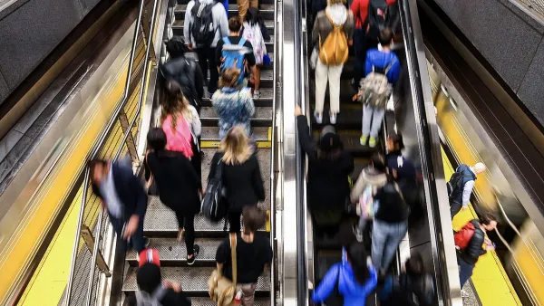
Transit agencies use complex models to predict future ridership, but these have not yet caught up with the still-changing post-pandemic travel needs of transit users.

With post-pandemic travel patterns still in flux, predicting transit ridership is becoming more challenging than ever, writes Jared Brey in Governing.
Despite the growth of sophisticated modeling methods in recent years, the most that many transit agencies can say at this point is that “The future is either going to be very bleak, surprisingly OK, or, in all likelihood, an unpredictable mixture of the two.” Brey explains that “Transit agencies try to predict future ridership for all types of scenarios — not just when making their yearly budgets but also when considering the impact of service changes or fare increases, and when applying for funding to build out new bus and train lines.” Now, agencies must collect new data to understand how the needs of transit users are changing.
Brey points out that even though ridership projections are used in federal grantmaking, “projections made in decades past have often proven to be wildly off-base.” More recently, agencies receiving New Starts federal grants are required to provide before-and-after studies to assess the accuracy of their projections.
Carole Turley Voulgaris, an assistant professor of urban planning at the Harvard Graduate School of Design, notes that “In some ways, the roughly sketched scenarios that many transit agencies are projecting in their budget documents have an advantage over highly complex processes that are used to generate a single prediction of the most likely future scenario.” With so much uncertainty still looming, understanding the range of possible scenarios can help agencies plan more effectively for a variety of future situations.
FULL STORY: Predicting Future Transit Ridership Is Trickier Than Ever

MTA Poised to Break Ridership, On-Time Service Records
New York City’s transit system saw strong increases in ridership and improvements in service quality in the first half of 2025.

LA Transit Ridership Plummets Amidst ICE Raids
LA Metro’s bus and rail lines are seeing up to 15 percent lower ridership in the wake of violent immigration arrests.

Florida Law Could Eliminate Dedicated Bus Lanes
A new law calls for a minimum ridership of 6,000 passengers in the first year for new bus rapid transit lines. To date, no bus lines in the Tampa Bay region come close.

Planetizen Federal Action Tracker
A weekly monitor of how Trump’s orders and actions are impacting planners and planning in America.

Chicago’s Ghost Rails
Just beneath the surface of the modern city lie the remnants of its expansive early 20th-century streetcar system.

Amtrak Cutting Jobs, Funding to High-Speed Rail
The agency plans to cut 10 percent of its workforce and has confirmed it will not fund new high-speed rail projects.

Ohio Forces Data Centers to Prepay for Power
Utilities are calling on states to hold data center operators responsible for new energy demands to prevent leaving consumers on the hook for their bills.

MARTA CEO Steps Down Amid Citizenship Concerns
MARTA’s board announced Thursday that its chief, who is from Canada, is resigning due to questions about his immigration status.

Silicon Valley ‘Bike Superhighway’ Awarded $14M State Grant
A Caltrans grant brings the 10-mile Central Bikeway project connecting Santa Clara and East San Jose closer to fruition.
Urban Design for Planners 1: Software Tools
This six-course series explores essential urban design concepts using open source software and equips planners with the tools they need to participate fully in the urban design process.
Planning for Universal Design
Learn the tools for implementing Universal Design in planning regulations.
Caltrans
City of Fort Worth
Mpact (founded as Rail~Volution)
City of Camden Redevelopment Agency
City of Astoria
City of Portland
City of Laramie