


More than one-half mile of elevated expressway was demolished in the heart of downtown Montréal to make way for a spectacular ground-level urban boulevard and over six acres of continuous public space, bookended by two monumental sculptures.
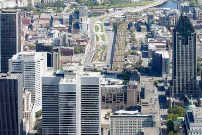
For more than 50 years, the elevated Bonaventure Expressway, built in 1966, cut across the city centre of Montréal, a thriving metropolis located on an archipelago in the middle of the majestic St. Lawrence River. This thoroughfare was a major gateway to the downtown core, accommodating more than 27,000 vehicles per day, including 1,900 buses. Rather than extending the service life of the aging structure, the city opted for a large-scale redevelopment, the first one of its kind in Canada, thereby making it possible to:
- Create an elegant, functional and people-oriented gateway to downtown Montréal
- Mesh together districts that were isolated by the elevated expressway
- Support private mixed-use development in the area
This bold initiative, spearheaded entirely by the City’s administration, forms the backbone of the Bonaventure Project which was completed on time and on budget (CAN$141.7 million).
In addition, Montréal was recently named Canada’s first recipient of a SITES certification, awarded by the Green Business Certification Inc. (GBCI) to honour the excellence demonstrated in implementing the innovative, sustainability-minded best practices that characterize the Bonaventure Project.
FULL STORY: Projet Bonaventure receives GBCI’s ‘SITES’ green building certification


Planetizen Federal Action Tracker
A weekly monitor of how Trump’s orders and actions are impacting planners and planning in America.

USGS Water Science Centers Targeted for Closure
If their work is suspended, states could lose a valuable resource for monitoring, understanding, and managing water resources.
End Human Sacrifices to the Demanding Gods of Automobile Dependency and Sprawl
The U.S. has much higher traffic fatality rates than peer countries due to automobile dependency and sprawl. Better planning can reduce these human sacrifices.

Trump: Federal Government Won’t Pay for California HSR
The President has targeted federal funding for the California bullet train project since his first administration.

San Francisco Enhances Urban Planning Initiatives with Green Infrastructure
San Francisco incorporates green infrastructure in its city development initiatives, elevating the importance of sustainability in urban planning.

Chicago Approves Green Affordable Housing Plan
The Mayor’s plan calls for creating a nonprofit housing corporation tasked with building affordable housing that meets Green Building standards.
Urban Design for Planners 1: Software Tools
This six-course series explores essential urban design concepts using open source software and equips planners with the tools they need to participate fully in the urban design process.
Planning for Universal Design
Learn the tools for implementing Universal Design in planning regulations.
Tyler Technologies
New York City School Construction Authority
Village of Glen Ellyn
Transportation Research & Education Center (TREC) at Portland State University
Chaddick Institute at DePaul University
Institute for Housing and Urban Development Studies (IHS)
Regional Transportation Commission of Southern Nevada
Toledo-Lucas County Plan Commissions