


Cleveland and Cuyahoga County are pushing ahead with an ambitious plan for a pedestrian and bike connection between downtown Cleveland and the lakefront.
"Cleveland, Cuyahoga County and the Group Plan Commission have formally launched the process of creating a long-desired pedestrian walkway to North Coast Harbor," reports Steven Litt.
"According to the document, the partners hope to have a preliminary design for the walkway bridge by Feb. 13, 2015. The goal is to finish construction by the spring of 2016, in time for the anticipated Republican National Convention in Cleveland."
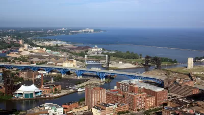
Litt employs a powerful metaphor to describe the potential of the project: "It has been a holy grail of Cleveland city planners for decades to create a stronger connection between the lakefront and downtown, which are separated by nearly a quarter-mile of roads and railroads, not to mention a 70-foot drop in elevation from downtown to the water's edge."

Study: Cuyahoga County Suburbs Ready for TOD
The growth of transit-oriented development in the Cleveland region is being hindered by zoning codes that limit housing density and excessive parking requirements that drive up construction costs, new research suggests.
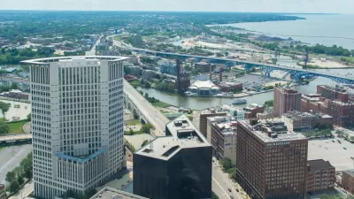
Cleveland Launches New Master Plan to Connect Downtown to Lake Erie
Dual, cooperating studies are underway in Cleveland to reimagine the connections between the city's downtown and lakefront.

Freeway Cap Park Proposed in the Heart of Cleveland
A proposal to cap part of the Innerbelt Freeway east of Downtown Cleveland would require the demolition of a vacant, historic courthouse near the East 22nd Street Bridge.

Planetizen Federal Action Tracker
A weekly monitor of how Trump’s orders and actions are impacting planners and planning in America.

San Francisco's School District Spent $105M To Build Affordable Housing for Teachers — And That's Just the Beginning
SFUSD joins a growing list of school districts using their land holdings to address housing affordability challenges faced by their own employees.

The Tiny, Adorable $7,000 Car Turning Japan Onto EVs
The single seat Mibot charges from a regular plug as quickly as an iPad, and is about half the price of an average EV.

Seattle's Plan for Adopting Driverless Cars
Equity, safety, accessibility and affordability are front of mind as the city prepares for robotaxis and other autonomous vehicles.

As Trump Phases Out FEMA, Is It Time to Flee the Floodplains?
With less federal funding available for disaster relief efforts, the need to relocate at-risk communities is more urgent than ever.

With Protected Lanes, 460% More People Commute by Bike
For those needing more ammo, more data proving what we already knew is here.
Urban Design for Planners 1: Software Tools
This six-course series explores essential urban design concepts using open source software and equips planners with the tools they need to participate fully in the urban design process.
Planning for Universal Design
Learn the tools for implementing Universal Design in planning regulations.
Smith Gee Studio
City of Charlotte
City of Camden Redevelopment Agency
City of Astoria
Transportation Research & Education Center (TREC) at Portland State University
US High Speed Rail Association
City of Camden Redevelopment Agency
Municipality of Princeton (NJ)