


Not usually regarded for their outside the box thinking, transportation engineers have nevertheless come up with some radical ideas for improving the flow of traffic and reducing the potential for collisions at busy intersections.
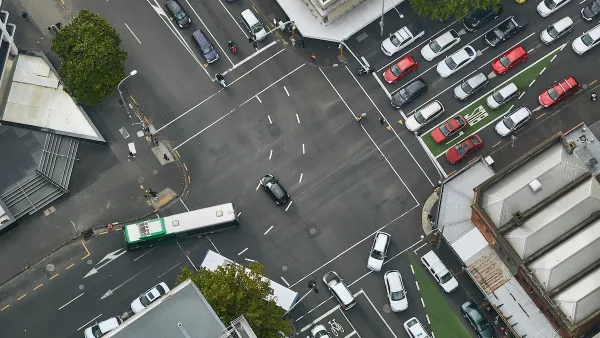
"Geometry tells us that the traditional four-way intersection is inherently dangerous," writes Emily Badger. "When you plot all of the potential points of conflict on a diagram – and transportation engineers actually do this – it turns out that vehicles have 32 distinct opportunities to collide into one another at the nexus of two two-lane roadways."
"With that geometry in mind, it becomes clear what we need in the holy grail of intersection design: a scheme that would eliminate left-hand turns while still enabling drivers to move in all four directions."
"John Sangster, a doctoral candidate at Virginia Tech and an alternative intersection enthusiast, introduced us to several and pointed us to some spellbinding animations from the Applied Technology and Traffic Analysis Program at the University of Maryland (many thanks to researchers there for sharing these clips)."
With such exotic names as the Jughandle, the Superstreet, and the Diverging Diamond, and even wilder traffic patterns, "these designs are not an easy sell."
"In theory – i.e., in conflict-point diagrams – these intersections should be safer than more traditional ones," says Badger. "But there are two caveats to that promise: Sangster is really talking about safer intersections for cars. Pedestrians and bikers aren’t figured into any of these models, and Sangster has yet to encounter designs that do a good job of incorporating them (or transit). There also isn’t much hard data on the safety of these designs because so few of them have been built (and even accurately modeling them on a computer can be tricky and expensive)."
FULL STORY: Could These Crazy Intersections Make Us Safer?

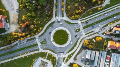
How I Learned to Stop Worrying and Love the Roundabout
What drives the U.S. backlash to roundabouts — objectively safer and more efficient than stop-and-go intersections?
How Understanding Near-Misses Can Improve Road Safety
Most road safety efforts are based on data about crashes that have already occurred. But important information can be gleaned from incidents when something almost went wrong, but didn’t.
Has Progress on Travel Safety Run Off the Road?
Changing technology and rebuilding infrastructure to improve road safety are long-term strategies. How can enforcement and interventions that influence driver behavior make a difference in reducing traffic deaths sooner?

Planetizen Federal Action Tracker
A weekly monitor of how Trump’s orders and actions are impacting planners and planning in America.

Map: Where Senate Republicans Want to Sell Your Public Lands
For public land advocates, the Senate Republicans’ proposal to sell millions of acres of public land in the West is “the biggest fight of their careers.”

Restaurant Patios Were a Pandemic Win — Why Were They so Hard to Keep?
Social distancing requirements and changes in travel patterns prompted cities to pilot new uses for street and sidewalk space. Then it got complicated.

Platform Pilsner: Vancouver Transit Agency Releases... a Beer?
TransLink will receive a portion of every sale of the four-pack.

Toronto Weighs Cheaper Transit, Parking Hikes for Major Events
Special event rates would take effect during large festivals, sports games and concerts to ‘discourage driving, manage congestion and free up space for transit.”

Berlin to Consider Car-Free Zone Larger Than Manhattan
The area bound by the 22-mile Ringbahn would still allow 12 uses of a private automobile per year per person, and several other exemptions.
Urban Design for Planners 1: Software Tools
This six-course series explores essential urban design concepts using open source software and equips planners with the tools they need to participate fully in the urban design process.
Planning for Universal Design
Learn the tools for implementing Universal Design in planning regulations.
Heyer Gruel & Associates PA
JM Goldson LLC
Custer County Colorado
City of Camden Redevelopment Agency
City of Astoria
Transportation Research & Education Center (TREC) at Portland State University
Camden Redevelopment Agency
City of Claremont
Municipality of Princeton (NJ)