


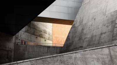
Nate Berg looks at how Hong Kong's unique pedestrian infrastructure of elevated walkways and underground tunnels has affected the city's use of public and private spaces, and shifted urban behaviors.
As the home to an interconnected series of elevated and underground passages that give pedestrians seemingly unlimited right-of-way without ever setting foot on actual ground, Hong Kong has generated a unique type of urban public space.
The result is a highly effective breed of "aformal urbanism," says Jonathan D. Solomon, associate dean at the School of Architecture at Syracuse University and co-author of the new book Cities Without Ground: A Hong Kong Guidebook. "You're constantly shifting from underground to above ground, from interior to exterior, from air-conditioned to non-air-conditioned, from public to private, and the dimensions are constantly going from large spaces to tighter spaces."
"Solomon says these walkways are incredibly vibrant parts of town, and represent a new method of providing usable space within a city," notes Berg. "The maps in Cities Without Ground seek to show that this system of walkways – messy and aformal and almost completely separate from the actual ground of the city – is just as important to Hong Kong as the sidewalks and public spaces of any other city."
FULL STORY: Hong Kong, the City Without Ground


How Public Spaces Exclude Teen Girls
Adolescent girls face unique challenges and concerns when navigating public spaces. We can design cities with their needs in mind.

The Trouble With QUIMBY
The idea of “quality urbanism in my back yard” has its uses, but should not be used to limit housing supply.
What ‘The Brutalist’ Teaches Us About Modern Cities
How architecture and urban landscapes reflect the trauma and dysfunction of the post-war experience.

Planetizen Federal Action Tracker
A weekly monitor of how Trump’s orders and actions are impacting planners and planning in America.

Map: Where Senate Republicans Want to Sell Your Public Lands
For public land advocates, the Senate Republicans’ proposal to sell millions of acres of public land in the West is “the biggest fight of their careers.”

Restaurant Patios Were a Pandemic Win — Why Were They so Hard to Keep?
Social distancing requirements and changes in travel patterns prompted cities to pilot new uses for street and sidewalk space. Then it got complicated.

Platform Pilsner: Vancouver Transit Agency Releases... a Beer?
TransLink will receive a portion of every sale of the four-pack.

Toronto Weighs Cheaper Transit, Parking Hikes for Major Events
Special event rates would take effect during large festivals, sports games and concerts to ‘discourage driving, manage congestion and free up space for transit.”

Berlin to Consider Car-Free Zone Larger Than Manhattan
The area bound by the 22-mile Ringbahn would still allow 12 uses of a private automobile per year per person, and several other exemptions.
Urban Design for Planners 1: Software Tools
This six-course series explores essential urban design concepts using open source software and equips planners with the tools they need to participate fully in the urban design process.
Planning for Universal Design
Learn the tools for implementing Universal Design in planning regulations.
Heyer Gruel & Associates PA
JM Goldson LLC
Custer County Colorado
City of Camden Redevelopment Agency
City of Astoria
Transportation Research & Education Center (TREC) at Portland State University
Camden Redevelopment Agency
City of Claremont
Municipality of Princeton (NJ)