One of the bedrocks of the Vancouver city-building story, which we often refer to as "the most important decision Vancouver ever made", was the dramatic rejection of inner city freeways in the late 60's/early 70's. This left our city frequently referenced as the only major North America city without a freeway. That decision led us down the very different and counter-intuitive path for livability, mobility, inner city density and urbanism that has come to be referred to as "the Vancouver Model".
One of the bedrocks of the Vancouver city-building story, which we often refer to as "the most important decision Vancouver ever made", was the dramatic rejection of inner city freeways in the late 60's/early 70's. This left our city frequently referenced as the only major North America city without a freeway. That decision led us down the very different and counter-intuitive path for livability, mobility, inner city density and urbanism that has come to be referred to as "the Vancouver Model".
To help you visualize the implications of this decision, here's where the freeways would have gone.
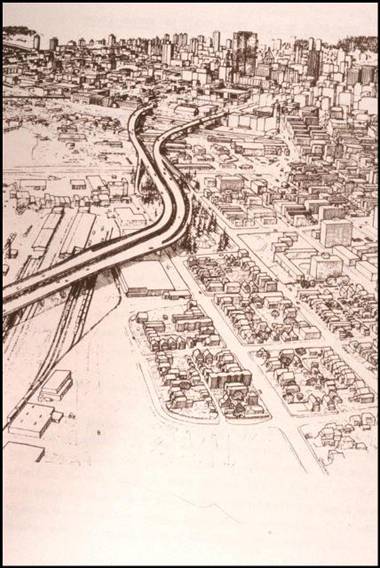
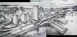
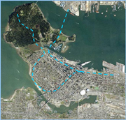
I often suggest though, that there could be an asterix beside that "no freeways" statement. Vancouver did build (actually, more accurately, we rebuilt) a piece of supporting infrastructure that anticipated the freeways; the Georgia and Dunsmuir viaducts into our downtown.
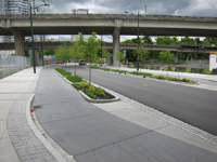
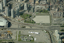
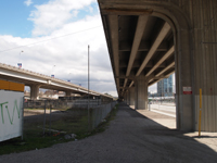
Originally constructed in 1915 to bypass the tidal waters, rail lines and industrial uses below, the current structures were rebuilt in the 1960s as the first piece of the larger freeways system that was ultimately rejected. Forty years have passed since the ribbon cutting, and the utility and merit of these structures continues to be debated in our city.
The past few decades have brought significant changes to the area below and surrounding the viaducts – indeed, the area has been dramatically transforming, and many question the necessity of these structures given new use potential they represent, and the barriers and disconnects they create, physically, visually and psychologically. Perhaps this piece of freeway-like infrastructure, can now be removed, drawing inspiration from transformations like the Embarcadero in San Francisco, or Seoul Korea's Cheonggyecheon, where an elevated highway was removed to create a tremendously successful urban recreation space featuring a day-lighted stream.
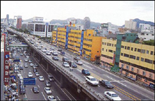
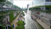
Before After
Others though, see the viaducts as a key feature in our downtown transportation system, and in their daily commute, and want them left as part of our car and goods-movement infrastructure (noting that in recent years, we've already added a separated bike-lane to the Dunsmuir viaduct). Still others would see them stay put, but see their nature changing from car environment to public realm or active transport corridor, as we've seen in New York's wildly popular High Line Park. Perhaps also, their underneath experience can be transformed to something more engaging and enlivening.
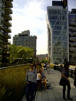
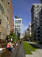
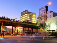
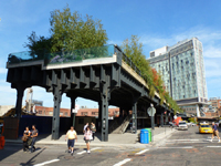
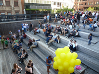
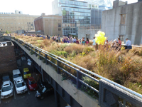
To be sure, the context, scale and nature of our viaducts is very different from the High Line, and cities everywhere should be careful not to see the successful NY elevated park as sparking a new global "Bilbao Effect" frenzy (where cities seek to replicate a good idea in the wrong way or place, often for the wrong reasons). One thing's for sure though – the viaducts are capable of being something much better than they are for the city, whether they stay or go.
Another sure thing - the viaduct's future has significant implications for city-building in Vancouver's downtown core. To bring clarity to the questions, in 2010 Vancouver launched a study to analyze options. Through initial staff and consultant analysis we revealed that any transportation impacts of alterations to the viaducts were manageable in the longer term provided that there is continued investment in transit, walking and cycling to accommodate current travel demand and future growth. Put another way, we determined that there were no long-term transportation "show-stoppers" to removal of the viaducts – a significant conclusion that generated big headlines, and a fair amount of debate across Vancouver.
Vancouver Sun Newspaper: "No "show-stopper" reason why Viaducts can't be removed"
New Urban News: Sole links in Vancouver's 1960s freeway plan may be razed
To keep the momentum going, in July of this year City Council approved the next phase of work on the viaducts, which includes an analysis of land use, cost, development potential and structural reconfiguration options. Here's the staff report and work program, for those of you seeking deeper background.
We (planning and engineering staff) recommended that the future of the viaducts be contemplated in the context of the broader area they fall within, which we dubbed the "Eastern Core." This area includes the strategically important job-space lands of the False Creek Flats, and connects numerous neighbourhoods and districts at the ‘neck" of the downtown peninsula, each going though their own evolutions.
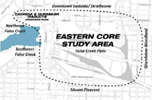
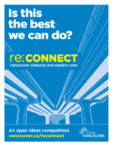
We also committed to Council that we would engage the public in a dialogue about the viaducts and Eastern Core in innovative and creative new ways. To that end, amongst other things we have launched re:CONNECT - an open ideas competition for all interested members of the public and professionals on the future of the Vancouver viaducts and Eastern Core. Please do check out our competition website, for lots more information and details. As hoped, the local buzz and energy around the competition has already been tremendous!
Readers of my blog know that for some time I've been studying the power of competitions on our city's design culture, and as a tool for engagement and creative thinking. Here's one of my past posts, on the subject.
Over and above the creativity of our local citizens, and the considerable local design talent Vancouver is blessed with, I'm hoping that Planetizen readers might be interested in participating in the competition, no matter where you're from! We've already received over 70 registrations, from over a dozen countries, and there's still 2 weeks to go to register. Please do take a look, and consider throwing your creative ideas into the mix!
While no decisions on the viaducts are being made through re:CONNECT, we're confident that fresh, new ideas will spark dialogue and help inform, influence and inspire planning for this part of Vancouver.
The competition is divided into two entry streams -- free and fee. Both streams will accept submissions in three categories: Big Picture, Viaducts, and Wild Card.
The free stream is directed toward citizens of Vancouver and elsewhere from any background, who can enter without an entry fee. Winning ideas will appear in post-competition literature that will be made available online and presented to City Council. The winners from this stream will also have their ideas profiled at a public forum.
The fee stream, while open to anyone who wishes to enter, is directed more at design professionals such as urban designers, city planners, architects and engineers. This stream requires a small entry fee and will include a monetary award for winning entrants, and winners will be profiled widely along with the winners of the free stream.
Only about two weeks remain until the submission deadline for re:CONNECT. Registration deadline is Wednesday, November 2nd with submission due by Friday, November 4th. An independent design jury, made up of renowned local and international architects, urbanists, educators, sustainability and economics experts (including Great Streets author and great urbanist Allan Jacobs), will choose the winners in both streams. There will also be public voting to select a ‘People's Choice' winner in each of the categories (online voting will run from November 21-25, 2011). Winners will be celebrated and profiled at a public forum in early December.
If the refusal of the freeways was the most important decision Vancouver ever made, then perhaps this is our generation's chance to make the next great decision for our city's future – and you have a chance to influence that decision!

Planetizen Federal Action Tracker
A weekly monitor of how Trump’s orders and actions are impacting planners and planning in America.

Chicago’s Ghost Rails
Just beneath the surface of the modern city lie the remnants of its expansive early 20th-century streetcar system.

Amtrak Cutting Jobs, Funding to High-Speed Rail
The agency plans to cut 10 percent of its workforce and has confirmed it will not fund new high-speed rail projects.

Ohio Forces Data Centers to Prepay for Power
Utilities are calling on states to hold data center operators responsible for new energy demands to prevent leaving consumers on the hook for their bills.

MARTA CEO Steps Down Amid Citizenship Concerns
MARTA’s board announced Thursday that its chief, who is from Canada, is resigning due to questions about his immigration status.

Silicon Valley ‘Bike Superhighway’ Awarded $14M State Grant
A Caltrans grant brings the 10-mile Central Bikeway project connecting Santa Clara and East San Jose closer to fruition.
Urban Design for Planners 1: Software Tools
This six-course series explores essential urban design concepts using open source software and equips planners with the tools they need to participate fully in the urban design process.
Planning for Universal Design
Learn the tools for implementing Universal Design in planning regulations.
Caltrans
City of Fort Worth
Mpact (founded as Rail~Volution)
City of Camden Redevelopment Agency
City of Astoria
City of Portland
City of Laramie


